- Collin County Regional Airport at McKinney
-
Collin County Regional Airport at McKinney 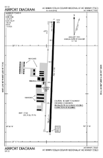
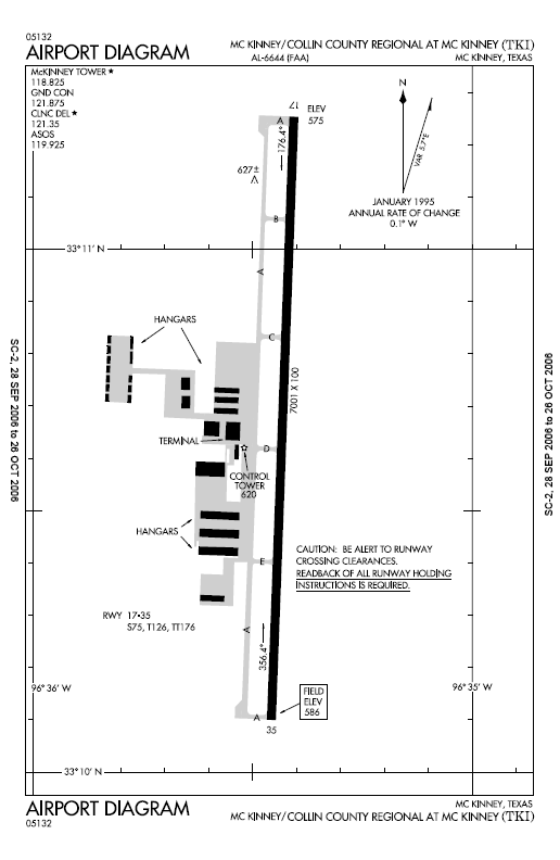
FAA airport diagram IATA: none – ICAO: KTKI – FAA LID: TKI Summary Airport type Public Owner City of McKinney Serves Collin County (McKinney, Plano, Richardson, Frisco, Allen), Texas Elevation AMSL 585 ft / 178 m Coordinates 33°10′41″N 096°35′26″W / 33.17806°N 96.59056°W Runways Direction Length Surface ft m 17/35 7,001 2,134 Concrete Statistics (20011) Aircraft operations 83,000 Based aircraft 242 Source: Federal Aviation Administration[1] Collin County Regional Airport at McKinney (ICAO: KTKI, FAA LID: TKI) is a public use airport located 30 miles north of Dallas, Texas.
Although most U.S. airports use the same three-letter location identifier for the FAA and IATA, this airport is assigned TKI by the FAA but has no designation from the IATA[2] (which assigned TKI to Tokeen Seaplane Base in Alaska[3]).
The airport is used entirely for general aviation purposes and serves as a reliever airport for Dallas Love Field. The airport is owned by the City of McKinney and is home to many business aircraft including the fleet of several Top 500 corporations. Currently, the only fixed based operator (FBO) on the field is Cutter Aviation. There are several places to receive flight training on the field. These include Monarch Air, the North Texas Flying Club, the Texins Flying Club and many independent flight instructors.
The airport is wrapping up an aggressive Capital Program that includes the construction of a replacement runway by the end of 2012. In Feb. 2011, CCRA completed a new control tower and three taxilanes to allow access to various areas around the airport.
Facilities and aircraft
Collin County Regional Airport covers an area of 745 acres (301 ha) at an elevation of 585 feet (178 m) above mean sea level. The current runway at the field is runway 17/35, with a concrete surface 7,001 feet (2,134 m) long by 100 feet (30 m) wide.[1] It is equipped with medium intensity runway lights, MALSR approach lights, runway 17 PAPI, and runway 35 VASI. Runway 17 is equipped with a Category I ILS approach.
The replacement runway will be designated 18/36 with a concrete surface 7,002 feet (2,134m) long by 150 feet (45.72m) wide. It will be equipped with high intensity runway lights, MALSR approach lights to Runway 18 and MALS approach lights to Runway 36, PAPI lights for runways 18 and 36, a runway 18 ILS Category I approach and RNAV approaches to both 18 and 36.
For the 12-month period ending Sept. 30, 2011, the airport had 83,000 aircraft operations, an average of 277 per day: 99% general aviation, 1% air taxi and <1% military. At that time there were 242 aircraft based at this airport: 77% single-engine, 17% multi-engine, 5% jet and 1% helicopter.[1]
The airport is a controled field with a contract FAA control tower open between 6:00 a.m. and 10:00 p.m.
References
- ^ a b c FAA Airport Master Record for TKI (Form 5010 PDF), effective 2009-05-07.
- ^ Great Circle Mapper: KTKI - McKinney, Texas (Collin County Regional Airport)
- ^ Great Circle Mapper: TKI / 57A - Tokeen, Alaska (Tokeen SPB)
External links
- Collin County Regional Airport, official website
- FAA Airport Diagram (PDF), effective 20 October 2011
- FAA Terminal Procedures for TKI, effective 20 October 2011
- Resources for this airport:
- AirNav airport information for KTKI
- FlightAware airport information and live flight tracker
- NOAA/NWS latest weather observations
- SkyVector aeronautical chart, Terminal Procedures for KTKI
Airfields in Dallas–Fort Worth–Arlington International Regional Dallas Love Field (DAL)Municipal Addison Airport (ADS) • Airpark East Airport (1F7) • Air Park-Dallas Airport (F69) •Alliance Airport (AFW) • Arlington Municipal Airport (GKY) • Bourland Field (50F) • Collin County Regional Airport at McKinney (TKI) • Kenneth Copeland Airport (4T2) • Denton Municipal Airport (DTO) • Executive Airport (RBD) • Flying C Airport (T87) • Fort Worth Spinks Airport (FWS) • Grand Prairie Municipal Airport (GPM) • Hicks Airfield (T67) • Ironhead Airport (T58) • Lakeview Airport (30F) • Lancaster Airport (LNC) • Lane Field Airport (58F) • Mesquite Metro Airport (HQZ) • Northwest Regional Airport (58F) • Phillips Flying Ranch Airport (T48) • Sycamore Strip Airport (9F9)Military Categories:- Airports in Texas
- Airports in the Dallas-Fort Worth Metroplex
- Buildings and structures in Collin County, Texas
- Transportation in Collin County, Texas
- Texas airport stubs
Wikimedia Foundation. 2010.