- RTA Rapid Transit
-
GCRTA Rapid Transit 
Info Owner Greater Cleveland Regional Transit Authority Locale Cuyahoga County, Ohio Transit type Rapid transit
Light railNumber of lines 1 Rapid transit: Red Line
2 Light rail: Blue and Green lines[1]
1 Bus rapid transit: HealthLineNumber of stations 18 Rapid transit
34 Light rail[1]Daily ridership 19,300 (Rapid transit)
10,800 (Light rail)[2]Operation Began operation April 11, 1920 (light rail)
March 15, 1955 (Rapid transit)Operator(s) Greater Cleveland Regional Transit Authority Number of vehicles 60 Rapid transit cars
48 Light rail cars[1]Technical Track gauge 4 ft 8 1⁄2 in (1,435 mm) Standard gauge RTA Rapid Transit (generally known as The Rapid) is a rapid transit and light rail system in Cleveland and Cuyahoga County owned by the Greater Cleveland Regional Transit Authority (RTA). The system comprises three lines—the Red Line (rapid transit) and Blue and Green Lines (light rail).
Contents
Lines
All four (Red, Green, Blue and Waterfront) lines join at Tower City Center in downtown Cleveland, the former Cleveland Union Terminal. From Tower City to East 55th the three (Red, Green and Blue) lines share track and stations. This sharing of one route between light and heavy rail is quite unusual, and the shared stations have connected platforms of two heights to accommodate the two kinds of trains. The two types of trains both use the same maintenance facility since they both use the same track gauge and same source of power (overhead catenary). Also, all three of the lines share one set of track at two of the three stations that are served by all three lines. The two stations where all of the lines are on one set of track are East 55th and East 34th-Campus. They then separate into three separate sets of track again before reaching Tower City Station.
Red (heavy rail)
The Red Line, a heavy-rail route, runs in both directions on fully grade-separated rights-of-way, built from 1955 to 1968. It serves Cleveland's southwest suburbs with its southwestern terminus at Cleveland Hopkins International Airport. Heading northeast, the Red Line serves University Circle before heading to its northeastern terminus at the Louis Stokes Station at Windermere in East Cleveland.
Light rail
Blue and Green
The Blue and Green light rail lines were built from 1913 to 1936 as grade separated lines closer to downtown and surface lines along street medians in the streetcar suburb of Shaker Heights. The two lines part ways at Shaker Square, a historic mixed use community in Cleveland proper, just west of the Shaker Heights border. The Green line continues due east along Shaker Boulevard (State Route 87) until reaching its terminus at the intersection with Green Road. The Blue Line veers southeast along Van Aken Boulevard until reaching its terminus at the intersection of Warrensville Center Road, Northfield Road (State Route 8) and Chagrin Boulevard (U.S. Route 422).
Waterfront
 Light rail vehicle on the Waterfront Line
The Waterfront Line, opened in 1996, extends the Blue and Green Lines from Tower City north to Lake Erie and northeast along the lakeshore. The Waterfront light rail line provides access from Tower City Center to the Flats, Cleveland Browns Stadium, the Great Lakes Science Center, the Rock and Roll Hall of Fame and Burke Lakefront Airport.
HealthLine (bus rapid transit)
Main article: HealthLineSince October 2008, RTA has operated a bus rapid transit line, originally referred to as "Silver Line", running along Euclid Avenue, providing a direct route between Cleveland's primary tourist attractions from Downtown Cleveland through Midtown Cleveland and University Circle to East Cleveland. Naming rights for the BRT were bought by The Cleveland Clinic and University Hospitals, and the line was named the HealthLine.[3]
Fares
Effective September 1, 2009, the one-way cash fare on the RTA Rapid Transit is $2.25. A five-ride fare card can be purchased for $11.25. An All-Day pass, allowing unlimited riding on the rapid transit as well as on RTA buses is $5.00 ($2.50 for children). Weekly and monthly passes are also available, and there are discounted fares for seniors and disabled. [1]
Map
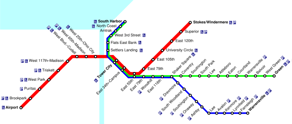 RTA Rapid Transit system map. The Red, Blue and Green Lines share trackage from Tower City east to roughly East 68th Street.
See also
- List of rapid transit systems
- List of light rail transit systems
- List of rail transit systems in the United States
References
- ^ a b c d "About RTA - RTA Facts". Greater Cleveland Regional Transit Authority. http://www1.gcrta.org/ar_RTAfacts.asp. Retrieved 2008-07-19.
- ^ APTA Quarterly Transit Ridership Report, 3rd Qtr 2006. p. 17.
- ^ Hollander, Sarah (2008-02-28). "Clinic, UH pay to name Euclid Corridor buses". The Plain Dealer. http://blog.cleveland.com/medical/2008/02/clinic_uh_pay_to_name.html. Retrieved 2008-09-18.
- "RTA Rapid Transit System Map" (PDF). Greater Cleveland Regional Transit Authority. http://www1.gcrta.org/pdf/maps/System_Map_Rapid.pdf. Retrieved 2008-07-19.
External links
- Greater Cleveland Regional Transit Authority - Maps and Schedules
- Jon Bell - Cleveland, Ohio: Transit Links
- Cleveland, Ohio - Rapid Transit (RTA)
- nycsubway.org - Cleveland, Ohio
- Northern Ohio Railway Museum
RTA Rapid Transit lines Currently operating heavy rail rapid transit systems in the United States Massachusetts Bay Transportation Authority (Blue, Orange, and Red Lines) · MTA (New York City Subway and Staten Island Railway) · Port Authority Trans-Hudson · Southeastern Pennsylvania Transportation Authority (Market–Frankford and Broad Street lines) · PATCO Speedline · Baltimore Metro Subway · Washington Metro · Metropolitan Atlanta Rapid Transit Authority · Miami Metrorail · San Juan Tren Urbano · Cleveland Red Line · Chicago 'L' · Bay Area Rapid Transit · Los Angeles Metro Rail (Red and Purple Lines)
Currently operating light rail and streetcar systems in the United States ArkansasArizonaCaliforniaMUNI: Cable Car, F Market & Wharves, and Metro lines · Metro Rail: Blue Line, Green Line and Gold Line · Sacramento RT · San Diego Trolley · Sprinter · Santa Clara VTA · Waterfront Red CarColoradoFloridaGeorgiaRiver Street StreetcarLouisianaMassachusettsMarylandMinnesotaMissouri / IllinoisNew JerseyNew YorkNorth CarolinaOhioOregonPennsylvaniaPittsburgh Light Rail · SEPTA Routes 15, 101, 102, and Subway–Surface LinesTennesseeTexasUtahVirginiaWashingtonWisconsinCategories:- RTA Rapid Transit
- Rapid transit in Ohio
- Light rail in Ohio

Wikimedia Foundation. 2010.