- Stody
-
Coordinates: 52°52′22″N 1°03′15″E / 52.87291°N 1.05409°E
Stody 
Saint Mary Parish Church, Stody
 Stody
Stody
Stody shown within NorfolkArea 7.99 km2 (3.08 sq mi) Population 181 (parish, 2001 census) - Density 23 /km2 (60 /sq mi) OS grid reference TG050350 - London 125 miles (201 km) Parish Stody CP District North Norfolk Shire county Norfolk Region East Country England Sovereign state United Kingdom Post town MELTON CONSTABLE Postcode district NR24 Dialling code 01263 Police Norfolk Fire Norfolk Ambulance East of England EU Parliament East of England List of places: UK • England • Norfolk Stody is a village and a civil parish in the English county of Norfolk.[1] The village is 13.2 miles (21.2 km) west south west of Cromer, 21.8 miles (35.1 km) north north west of Norwich and 125 miles (201 km) north north east of London. The village lies 4.1 miles (6.6 km) south west of the town of Holt.The nearest railway station is at Sheringham for the Bittern Line which runs between Sheringham, Cromer and Norwich. The nearest airport is Norwich International Airport.
Contents
History
Stody has an entry in the Domesday Book of 1085.[2] In the great book Stody is recorded by the name ‘’Estodeia’’ and “Stodeia it is said to be in the ownership of the King. The main tennent was Humphrey from Ranulf brother of Ilger. The survey also notes that there were three mills, three Beehives and sixty Goats. The name Stody derives from “an enclosure for horses”, the modern English word 'stud' comes from the same root
Village amenities
- Stody Estate, The Earl of Lothian owned this estate in the latter part of the Nineteenth Century along with the near-by Blickling Estate. In 1932 the Estate was purchased by Lord Rothermere who built the existing house after the original house was largely destroyed by fire. The estate was sold to George Knight in 1941 and is farmed by his stepson's family today. The Land is all in hand. By today’s standards the farm is quite diverse, but 40 years ago the Estate was well known for its pedigree herds and flocks, fruit farm, poultry and flowers.
- Stody Lodge Gardens opens each year in May. The gardens comprise of 10 acres (40,000 m2) of Rhododendron and Azalea gardens.
The Parish Church of Mary
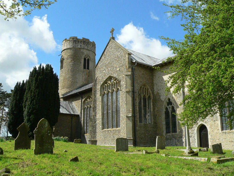
The Parish Church of Saint Mary is constructed from flint and has a Saxon period round tower.[3]There is a nave, chancel and two transepts and a fine example of cross-vaulting at the poit of the intersection. The church has a collections of 15th-century stained glass figures. They are set high in the lights of the north side windows, and in the east side of the south transept. At the west end of the church there is a 13th-century Purbeck marble font.[4] The church is a Grade I listed building [1].
Notable people
- The Reverend Thomas Pyle was born at Stody in 1674 and died Swaffham, Norfolk, 31 December 1756 and was a Church of England clergyman and religious controversialist.
External links
References
- ^ OS Explorer Map 24 - Norfolk Coast Central. ISBN 0 319 21726 4.
- ^ The Domesday Book, Englands Heritage, Then and Now, Editor: Thomas Hinde,Norfolk page 194 ISBN 1858334403
- ^ Norfolk 1: Norwich and North-East, By Nikolaus Pevsner and Bill Wilson, Stody entry. ISBN 0-300-09607-0
- ^ The King’s England series, NORFOLK, by Arthur Mee,Pub:Hodder and Stoughton,1972, page 290 Stody, ISBN 0 340 15061 0
Categories:- Villages in Norfolk
- Civil parishes in Norfolk
- Norfolk geography stubs

Wikimedia Foundation. 2010.