- Colby, Norfolk
-
Coordinates: 52°50′10″N 1°17′56″E / 52.83598°N 1.29883°E
Colby 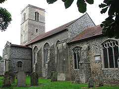
Parish Church of Saint Giles, Colby, Norfolk
 Colby
Colby
Colby shown within NorfolkArea 8.34 km2 (3.22 sq mi) Population 524 (2001 census) - Density 63 /km2 (160 /sq mi) OS grid reference TG222316 - London 131 miles (211 km) Parish Colby CP District North Norfolk Shire county Norfolk Region East Country England Sovereign state United Kingdom Post town NORWICH Postcode district NR11 Dialling code 01263 Police Norfolk Fire Norfolk Ambulance East of England EU Parliament East of England List of places: UK • England • Norfolk Colby is a village and a civil parish in the English county of Norfolk [1].The village is 8.6 miles (13.8 km) south of Cromer, 16.8 miles (27.0 km) north-north-west of Norwich, 5.2 miles (8.4 km) west-north-west of North Walsham and 131 miles (211 km) north-east of London. The nearest railway station is at North Walsham Railway station where the Bittern Line from Cromer to Norwich can be accessed and the national rail network beyond. The nearest airport is Norwich International Airport. The village lies a small distance east from the A140 Cromer to Norwich road[2]. The parish of Colby in the 2001 census, has a population of 524. For the purposes of local government, the parish falls within the district of North Norfolk.
Description
The parish is in the north-east of the county and is a short distance north-east from the town of Aylsham and south of the estates of Gunton Park. The name of the village derives from the translated from Old Norse as farmstead or village of a man called Koli[3].
References
- ^ Ordnance Survey, Explorer Sheet 252, Norfolk Coast East, ISBN 9780319467268
- ^ County A to Z Atlas, Street & Road maps Norfolk, Page 128, ISBN 978-1-84348-614-5
- ^ A Popular Guide to Norfolk Place-names: by James Rye: Published by Larks press, Dereham, Norfolk, 2000 ; ISBN 0-948400-15-3
Categories:- Villages in Norfolk
- Civil parishes in Norfolk
- Norfolk geography stubs


Wikimedia Foundation. 2010.