- Potter Heigham
-
Coordinates: 52°43′03″N 1°34′28″E / 52.71741°N 1.57432°E
Potter Heigham 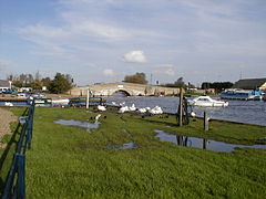
Potter Heigham's medieval bridge
 Potter Heigham
Potter Heigham shown within NorfolkArea 10.38 km2 (4.01 sq mi) Population 961 - Density 93 /km2 (240 /sq mi) OS grid reference TG415193 Parish Potter Heigham District North Norfolk Shire county Norfolk Region East Country England Sovereign state United Kingdom Post town GREAT YARMOUTH Postcode district NR29 Police Norfolk Fire Norfolk Ambulance East of England EU Parliament East of England List of places: UK • England • Norfolk Potter Heigham is a village and civil parish on the River Thurne in the English county of Norfolk. It is situated some 20 km (12 mi) north-east of the city of Norwich on the A149 road, and on The Broads.[1]
The civil parish has an area of 10.38 km2 (4.01 sq mi) and in the 2001 census had a population of 961 in 425 households. For the purposes of local government, the parish falls within the district of North Norfolk[2] although as in other broadland villages, the areas adjacent to the river fall under the administration of the Broads Authority.
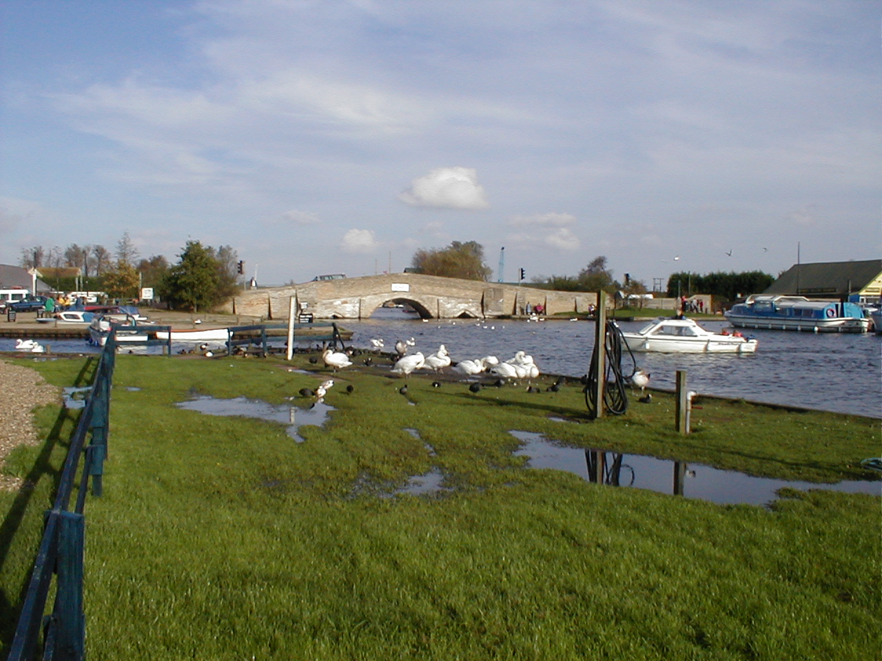
Potter Heigham has a medieval bridge, believed to date from 1385, famous for being the most difficult to navigate in the Broads. The bridge opening is so narrow that only small cruisers can pass through it, and then only at low water, usually with the help of resident pilot Greg Lochhead - there is a fee of £20 - £10 each way for holiday craft in the summer. A modern roadbridge is close by.
The village is part of the Ludham - Potter Heigham NNR, a National Nature Reserve. The Weavers Way, a long distance footpath, passes through the village on its way from Cromer to Great Yarmouth.
Contents
Broads Haven
 Broads Haven
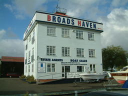
One of Potter Heigham's biggest and most striking features is the Broads Haven building, which is located next to the bridge. Located at the famous Herbert Woods boatyard, the building currently houses offices for Waterside Estate Agents and Waterside Marine Sales.
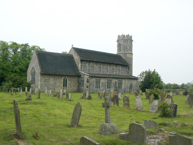
Church of St Nicholas
 Church of St Nicholas
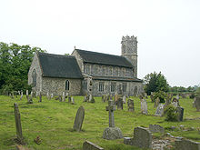
Potter Heigham church is dedicated to St Nicholas, the patron saint of fishermen and children. The earliest surviving feature is the round tower, which dates from the 12th century and has a 14th-century octagonal extension, one of the best preserved in the country.[3]
It is famed for its hammerbeam roof and the almost unique 15th-century brick font.[4] The church also contains a scheme of wall paintings dating from the 14th century, the most readable of which depicts the Seven Works of Mercy.[5] When the roof was re-thatched it required about 1850 bundles of reed. It is one of 124 existing round-tower churches in Norfolk. The church is a Grade I listed building.[6]
Buildings of note
Apart from the church of St Nicholas and the medieval bridge, Potter Heigham has a number of buildings of historic or architectural note. These include Heigham Holmes windpump to the east of the parish, High's mill on the River Thurne,[3] and Sunways corn mill,[7] all of which are listed buildings.
Potter Heigham at war
The parish of Potter Heigham has a number of features related to the World Wars. Hickling Broad, to the north of the parish, was used as a seaplane base during World War I. Part of Ludham Airstrip, a now shrunken remnant of a larger World War II airbase, is also built on parish lands, and there were a number of defensive structures around the medieval bridge.
Sidney Grapes
The Norfolk humourist Sidney Grapes lived and worked in Potter Heigham. He was famous for his collection of Norfolk dialect letters entitled The Boy John Letters, which were originally published in the Eastern Daily Press.
Notes
- ^ Ordnance Survey (2005). OS Explorer Map OL40 - The Broads. ISBN 0-319-23769-9.
- ^ Office for National Statistics & Norfolk County Council (2001). Census population and household counts for unparished urban areas and all parishes. Retrieved December 2, 2005.
- ^ a b Pevsner, N. and Wilson, B. (1991). The Buildings of England. Norfolk 2: North-West and South, London: Penguin Books.
- ^ Mortlock D. P. & Roberts, C. V. (1981) The Popular Guide to Norfolk Churches No. 1, North-East Norfolk . Acorn Editions.
- ^ Marshall, A. The Seven Works of Mercy, Potter Heigham, Norfolk. Retrieved December 08, 2006
- ^ "Images of England". http://www.imagesofengland.org.uk/details/default.aspx?id=224434.
- ^ Neville, J. (2004).Potter Heigham towermill, Retrieved December 08 2006.
External links
- Map sources for Potter Heigham.
- Information from Genuki Norfolk on Potter Heigham.
- Website with photos of Potter Heigham St. Nicholas, a round-tower church
- Southall, A. (2006).‘A Vision of Britain Through Time: Potter Heigham CP’
Categories:- North Norfolk
- Norfolk Broads
- Villages in Norfolk
- Civil parishes in Norfolk

Wikimedia Foundation. 2010.