- Chester (village), New York
-
Chester Village  View south along Main Street
Name origin: From city in England Country USA State New York Region Hudson Valley County Orange Town Chester Coordinates 41°21′27″N 74°16′32″W / 41.3575°N 74.27556°W Highest point Unnamed hill in S of village - elevation 572 ft (174 m) - coordinates 41°21′12″N 74°16′30″W / 41.35333°N 74.275°W Lowest point - location NE village line - elevation 420 ft (128 m) - coordinates 41°21′55″N 74°15′39″W / 41.36528°N 74.26083°W Area 2.1 sq mi (5 km2) Population 3,445 (2000) Density 1,628 / sq mi (629 / km2) Founded 1892 Government Village Hall, 47 Main Street - elevation 440 ft (134 m) - coordinates 41°21′43″N 74°16′21″W / 41.36194°N 74.2725°W Mayor Phil Valastro Timezone Eastern (EST) (UTC-5) - summer (DST) EDT (UTC-4) ZIP Code 10918 Area code 845 Exchange 469 FIPS Code 36-15297 GNIS feature ID 0946539 
 Location of Chester within New York
Wikimedia Commons: Chester, Orange County, New York Website: Village of Chester New York Chester is a village in Orange County, New York, United States. The population was 3,445 at the 2000 census. It was named after the City of Chester in England. Chester is part of the Poughkeepsie–Newburgh–Middletown, NY Metropolitan Statistical Area as well as the larger New York–Newark–Bridgeport, NY-NJ-CT-PA Combined Statistical Area.
The Village of Chester is primarily located in the northern part of the Town of Chester.
Contents
History
The village was incorporated in 1892.
At the center of a dairy industry, the village claims to be the birthplace of "Philadelphia Cream Cheese." Other brands produced in Chester were Clover Brand, Cow Brand, D’isigny, Fromage De Brie, Neufchatel, Star Brand and World Brand.[1]
Now the Village is considered Downtown Historic Chester where the Heritage trail starts at the old train station, connecting the towns of Monroe and Goshen. The Village hosts a variety of restaurants and stores, and most of the Buildings have been restored to their original building type.
Geography
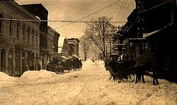 Main Street, Chester, New York, March, 1914.
Chester is located at 41°21′26″N 74°16′31″W / 41.35722°N 74.27528°W (41.357378, -74.275488)[2].
According to the United States Census Bureau, the village has a total area of 2.1 square miles (5.5 km²).None of the area is covered with water.
Chester is located on NY-94, north of NY-17.
Goose Pond Mountain State Park is southeast of the village.
Demographics
As of the census[3] of 2000, there were 3,445 people, 1,396 households, and 901 families residing in the village. The population density was 1,628.0 people per square mile (627.4/km²). There were 1,455 housing units at an average density of 687.6 per square mile (265.0/km²). The racial makeup of the village was 83.45% White, 7.72% Black or African American, 0.93% Native American, 2.96% Asian, 2.61% from other races, and 2.32% from two or more races. Hispanic or Latino of any race were 10.16% of the population.
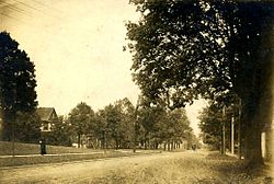 High Street looking towards Washingtonville, ca 1880.
There were 1,396 households out of which 30.7% had children under the age of 18 living with them, 50.8% were married couples living together, 10.5% had a female householder with no husband present, and 35.4% were non-families. 28.0% of all households were made up of individuals and 8.2% had someone living alone who was 65 years of age or older. The average household size was 2.45 and the average family size was 3.04.
In the village the population was spread out with 23.5% under the age of 18, 7.3% from 18 to 24, 36.7% from 25 to 44, 21.6% from 45 to 64, and 10.9% who were 65 years of age or older. The median age was 36 years. For every 100 females there were 92.4 males. For every 100 females age 18 and over, there were 89.0 males.
The median income for a household in the village was $55,417, and the median income for a family was $65,321. Males had a median income of $47,386 versus $31,957 for females. The per capita income for the village was $24,960. About 4.2% of families and 6.0% of the population were below the poverty line, including 7.7% of those under age 18 and 7.8% of those age 65 or over.
References
- ^ Discovering the Wheys and Means of Chester's Cheese History
- ^ "US Gazetteer files: 2010, 2000, and 1990". United States Census Bureau. 2011-02-12. http://www.census.gov/geo/www/gazetteer/gazette.html. Retrieved 2011-04-23.
- ^ "American FactFinder". United States Census Bureau. http://factfinder.census.gov. Retrieved 2008-01-31.
External links
- Village website
- Chester Historical Society Digital Collections
- Discovering the wheys and means of Chester’s cheese history
- The Chronicle, community newspaper
Municipalities and communities of Orange County, New York County seat: Goshen Cities 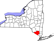
Towns Blooming Grove | Chester | Cornwall | Crawford | Deerpark | Goshen | Greenville | Hamptonburgh | Highlands | Minisink | Monroe | Montgomery | Mount Hope | New Windsor | Newburgh | Tuxedo | Wallkill | Warwick | Wawayanda | Woodbury
Villages Chester | Cornwall-on-Hudson | Florida | Goshen | Greenwood Lake | Harriman | Highland Falls | Kiryas Joel | Maybrook | Monroe | Montgomery | Otisville | South Blooming Grove | Tuxedo Park | Unionville | Walden | Warwick | Washingtonville | Woodbury
CDPs Other
hamletsAmity | Arden | Bellvale | Bullville | Circleville | Howells | Little Britain | Michigan Corners | Mountain Lodge Park | Mountainville | New Hampton | Pine Island | Ridgebury | Slate Hill | Sugar Loaf | Thompson Ridge | Westbrookville
Categories:- Populated places in Orange County, New York
- Villages in New York
- Poughkeepsie–Newburgh–Middletown metropolitan area


Wikimedia Foundation. 2010.