- Walden, New York
Geobox Settlement
name = Walden
native_name =
other_name =
other_name1 =
category = Village
image_size = 300
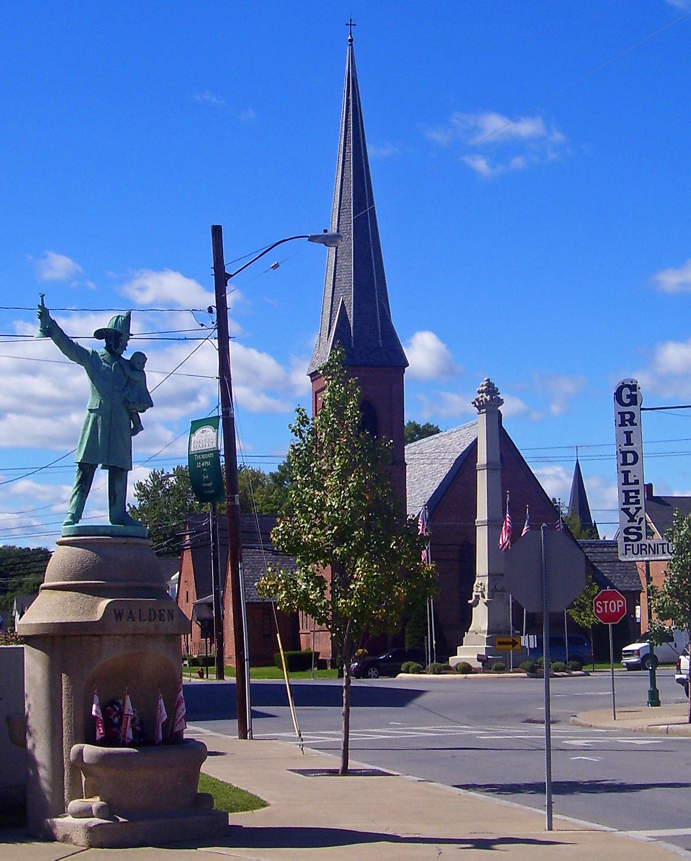
image_caption = Central Walden, with memorials and St. Andrew's Episcopal Church, in 2007
flag_size =
symbol_type = Seal
symbol = Village of Walden seal transparent.png
etymology = From Jacob T. Walden
country =United States
state =New York
region_type = County
region = Orange
district_type = Town
district = Montgomery
area_imperial = 5.3
location = Village Hall
lat_d = 41
lat_m = 33
lat_s = 36
lat_NS = N
long_d = 74
long_m = 11
long_s = 23
long_EW = W
elevation_imperial = 260
population_as_of = 2000
population = 6164
population_density_imperial = 3129.6
established_type = Incorporated
established = 1855
mayor = Becky Pearson
leader1_type = Village manager
leader1 = James Politi
timezone = Eastern
utc_offset = -5
timezone_DST = Eastern Daylight Time
utc_offset_DST = -4
postal_code = 12586
postal_code_type =ZIP Code
area_code = 845
area_code_type =
code2_type = Exchange
code2 = 778
free_type =
free =
free1_type =
free1 =

map_size =
map_caption = Location of Walden within the state of New York
map_locator = New York
map1 = Map of USA NY.svg
map1_caption = Location of New York in the United States
website = http://www.villageofwalden.org/Walden is the largest of three villages of the Town of Montgomery in Orange County,
New York ,USA . The population was 6,164 at the 2000 census. It has theZIP Code 12586 and the 778telephone exchange within the 845area code .The Village of Walden began in the early 18th century as a mill town along the
Wallkill River . One miller, Jacob Walden, was so successful the village that incorporated in the mid-19th century took its name from him. Later on, it would be the three separate knife manufacturers based in the village that brought it growth and prosperity. They are gone today, but other industrial concerns remain. Walden is best known in theHudson Valley as the home of the Thruway Marketshypermarket complex.History
The area around present-day Walden was purchased in 1736 by Alexander Kidd, and
settler s ofScots-Irish , English and German descent started arriving not long afterwards. It was the first settlement west of the Wallkill River, known at the time as Kidd's Town.In the 1820s, a successful New York shipper named Jacob Walden convinced some of his business partners to finance the construction of
wool en mills on the river, attracted by the Great Falls as a source of power and therailroad connections at nearby Maybrook. He dammed the Wallkill above the falls, creating a power station that remains in use today, and his mill was a success.Other wool-makers followed as the
Industrial Revolution picked up steam and the growing population center became known instead as Walden's Mills. Most of them failed a few decades later, but their influence was such that the village incorporated in 1855 as Walden.The village fathers needed to replace the mills as a source of employment, and began encouraging
knife manufacturers to relocate from nearby Dutchess County to the vacant buildings, where the New York Knife Company made much of the cutlery employed by theUnion Army during theU.S. Civil War .After the war, other knifemakers came to Walden, too, and the village became colloquially known as Knifetown. Other industrial concerns, making products as diverse as
engines and women's underwear, also set up shop.In the early 1890s, President
Grover Cleveland loweredtariff s on many imported goods, including knives. Competitively priced German cutlery began to flood the American market, and together with thePanic of 1893 and the economic slowdown that followed for several years, the knife companies and their owners went heavily intodebt and it looked for a while as if they might not survive.But in 1897President William McKinley , a personal friend of Robert Bradley of the U.S. Knife Company, pushed through theDingley Tariff that restored the "status quo ante ". The knifemakers returned to profitability and were able to pay off their debts; and in gratitude Bradley had a statue of McKinley erected that remains in Walden today.In the 1910s the facilities at the dam began to be primarily used for power and less for industry.
Walden's Main Street was the site of an active retail trade which included Millsbaugh's Furniture as well as Roosa's Jewelers, both still in business. Lustig's Department Store, established by Carl Lustig in 1883, was the mainstay of Main Street until its closing in 1986.
In the late 1920s, one of the largest
Ku Klux Klan gatherings outside the South in that era took place outside Walden.The Depression was hard on many of the village's economic concerns, but the knife makers persisted. However, after
World War II they gradually became less prominent and moved as the rail connections they had depended on were replaced bytrucking on the growingInterstate Highway s. The last company making knives in the village,Imperial Schrade , closed down its factory after a 1957 fire and moved to nearby Ellenville afterwards, where it lasted until 2004. The ruins of the factory still stand behind Walden's most visible economic giant, the Thruway Marketshypermarket .Today, Walden retains some light industry and much of its working-class feel, enough for the village to have gotten into a spat with WPDH-FM
disc jockey The Wolf in the late 1990s over his constant joking on- and off-air joking about Walden as a redneck town.Demographics
As of the
census GR|2 of 2000, there were 6,164 people, 2,197 households, and 1,577 families residing in the village. Thepopulation density was 3,129.6 people per square mile (1,208.1/km²). There were 2,352 housing units at an average density of 1,194.2/sq mi (461.0/km²). The racial makeup of the village was 90.61% White, 3.83% African American, 0.36% Native American, 0.63% Asian, 0.02% Pacific Islander, 2.69% from other races, and 1.87% from two or more races. Hispanic or Latino of any race were 9.34% of the population.There were 2,197 households out of which 40.1% had children under the age of 18 living with them, 50.9% were married couples living together, 14.6% had a female householder with no husband present, and 28.2% were non-families. 22.7% of all households were made up of individuals and 9.4% had someone living alone who was 65 years of age or older. The average household size was 2.79 and the average family size was 3.29.
In the village the population was spread out with 30.2% under the age of 18, 8.1% from 18 to 24, 31.5% from 25 to 44, 20.1% from 45 to 64, and 10.2% who were 65 years of age or older. The median age was 34 years. For every 100 females there were 92.3 males. For every 100 females age 18 and over, there were 90.4 males.
The median income for a household in the village was $43,507, and the median income for a family was $49,316. Males had a median income of $37,929 versus $25,701 for females. The
per capita income for the village was $18,485. About 5.5% of families and 9.8% of the population were below thepoverty line , including 13.1% of those under age 18 and 7.7% of those age 65 or over.Geography
Walden is located at coor dms|41|33|41|N|74|11|22|W|city (41.561268, -74.189442)GR|1. According to the
United States Census Bureau , the village has a total area of 2.0 square miles (5.3 km²), of which, 2.0 square miles (5.1 km²) of it is land and 0.1 square miles (0.2 km²) of it (3.90%) is water.The village's most notable geographical feature is theWallkill River , which flows from the south to the north across the village and divides one-third of it from the rest. Within the eastern portion,Tin Brook , the Wallkill's major righttributary in New York, meanders across as well, forming part of the northern village boundary. There are twowaterfall s anddam s on the river within the village limits, known as the Great and Little Falls; and two auto bridges, theWalden Veterans' Memorial Bridge (known colloquially as the High Bridge, which carries NY 52, known in the village as West Main Street) and Low (Oak Street) bridges).The Wallkill goes through a small gorge between the two dams and loses approximately 60 feet (18 m) of elevation in the process. The surrounding topography in the village is correspondingly gentle rolling hills of this section of theGreat Appalachian Valley between the higher rises of theShawangunk Ridge , visible to the west from some sections of the village, and theHudson Highlands to the southwest. The highest elevation is roughly 520 feet (158 m) above sea level along Overlook Road at the village's western boundary; the lowest is 260 feet (79 m) along the Wallkill at the northern village line.Walden's growth began near the mills and later the knife-making plants, particular the New York Knife Company, located on the steep east bank of the river just south of the Veterans' Memorial Bridge (footings can still be seen on the slope today). The central business district of the village is today a few blocks to the east, along Main Street. Just to its south is the
village hall and the main square. East Main Street, the section of 52 from the 208 junction to the village line, has seen many newer businesses locate there, including a small strip mall. There is also some scattered commercial presence along Orange Avenue (208 south of the junction), primarily professional office space. This parallels the village's remaining industrial presence along the railroad line to the east, which at its northern terminus abuts downtown to the southeast. Walden's other major commercial area is the Thruway Markets complex located along the river north of Oak Street, just south of the remains of the Walden Knife Company.The village boasts two large parks, Bradley Park (see below) on the high ground between Thruway Markets and Ulster Avenue (Route 208) in the northeast and Wooster Grove along Tin Brook in the west. There are two schools, public
Walden Elementary School on Orchard Street and CatholicMost Precious Blood near the northern village line along Ulster Avenue.Much of the remainder of the village is residential, with houses tending from modest and small near downtown, the river and railroad, to more expansive homes (such as the Victorians along the west side of Ulster Avenue) being found on the hills, and newer development near the southwestern and eastern borders with the town. Two largeaffordable housing complexes bracket the river just north of downtown, both of them participants in the federal Section 8 program, and there are sometrailer park s along Route 52 near the village's western line.A large tract along the river south of the power station had remained undeveloped until very recently. A small area between McKinley Avenue, South Mountgomery Street and the river remains open, used for NYSEG's purposes. On the other end of the village, the
sewage treatment plant is also in the middle of an undeveloped area.Transportation
Four state highways and two county roads serve Walden. Route 52 crosses the town from east to west, providing connections to Newburgh, 12 miles (19 km) in the latter direction and Pine Bush, the Shawangunks and the Catskills in the former. NY 208 crosses from north to south, with the nearest towns in each direction being Wallkill and Maybrook, respectively. The two share a brief block in the center of town. Most traffic from outside the area comes in via Route 208 from the south due to its exit on Interstate 84 about five miles (9 km) south of the village, as well as its intersection with paralleling NY 17K at Scotts Corners three miles (5 km) to the south. County routes 23 (River Road) and 75 (Coldenham Road) connect to 17K at Montgomery to the southwest and the hamlet of Coldenham to the southeast, respectively.
The remaining spur of the old
Wallkill Valley Railroad , now operated byNorfolk Southern , serves several businesses in the village and ends just short of East Main Street. There have been suggestions thatcommuter rail service via the Metro-North Port Jervis Line, where the spur connects at Campbell Hall, currently the nearest passenger rail station, be initiated. Metro-North rail service directly into New York City is available just across theHudson River from Newburgh at Beacon and other stations on theHudson Line .Amtrak stops at Poughkeepsie, the Hudson Line's northern terminus. The nearest airport to Walden, Orange County Airport, is ageneral aviation facility just south of Montgomery. Commercial airlines, both freight and passenger, fly out ofStewart International Airport .Economy
The knife making plants are gone, but other light-industrial concerns remain along the rail spur. The growing service sector is most strongly represented by two regional banks, Walden Federal and Walden Savings Bank, are based in the village (though the former has moved to new headquarters at Scotts Corners, the 17K/208 intersection).
Retailing has long been a strong point for the village. The opening of Thruway Markets in 1955 filled the need not only for asupermarket but the entire big box sector, long before it existed in the country at large. While it eventually drove smaller stores from Main Street, it remains a substantial part of the village's tax base and a major draw for consumers from outside not only Walden but the Town of Montgomery (particularly the nearby hamlet of Wallkill, which has no large retailers of its own), despite the openings of chain supermarkets in several nearby communities. Thruway is part of a strip-mall complex that also boasts an outdoor-recreation store, tire-repair shop and one of the village's two Chinese restaurants.While vacant space remains on Main Street, specialty stores and restaurants have managed to thrive there. Millspaugh Furniture, founded in Walden (but with another outlet in Poughkeepsie), is another popular draw for out-of-town shoppers due to its long history in the area and reputation for quality merchandise. National and regional chain stores once had little presence in Walden beyond two
gas station s along the 52/208 section of Main Street, but in the last decade the amount ofconvenience store s has doubled with the addition of a Stewart's along East Main Street, and fast-food chains Subway andDunkin' Donuts have found space nearby.Outside of jobs at the enterprises in the village, most residents work in the area. The nearby interstate and its associated "Golden Triangle" (with the
New York State Thruway /I-87 and NY 17 (the future I-86) provide many jobs in transportation and distribution, particularly at Maybrook'sYellow Freight facility and the large Stapleswarehouse just north of I-84. Local government agencies, and some state ones such as the Department of Correctional Services, also employ residents. More recently, residents of the newer housing have been commuters traveling to jobs inNew York City or other areas close to it.Government
As a village of the Town of Montgomery, Walden residents are taxpayers and electors in both.
The village has seven elected officials, a village board consisting of the
mayor and six nonpartisan trustees, per the New York State Village Law. Most of the executive functions are handled by the village manager, who serves at the board's pleasure.Walden has had this system of government since 1964. A 1972
referendum to return to a strong-mayor system was defeated.The village has its own
police force, which provides 24-hour protection for residents; a public works department which maintains roads, water andsewer lines; a skate park in Bradley Park which was built in Fall 2006 due to the on going complaints from older residents about all the skateboarders, a recreation department which maintains several parks within the village, including one with a pond in whichswimming is permitted; and a villagecourt presided over by an elected justice. Fire protection is provided for the village and surrounding fire district by the Walden Fire Department.The Village hall, pictured left, housed both the Walden Fire Department and Police Station until 1994 when the Fire District moved to a newly constructed firehouse at 230 Old Orange Avenue, near the edge of the village. Since then, the Police station on the ground floor has grown from a tiny office and a few cells to nearly encompassing the entire ground floor. Fire Department Meeting rooms on the second story have been converted since then to a children's section of the local Josephine-Louise Library.
References
External links
* [http://www.waldenpd.com Walden Police Department]
* [http://www.villageofwalden.org Village website]
* [http://waldenfire.com Walden Fire Department]
Wikimedia Foundation. 2010.