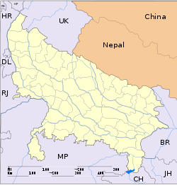
- Charkhari
-
Charkhari — city — Coordinates 25°24′N 79°45′E / 25.4°N 79.75°ECoordinates: 25°24′N 79°45′E / 25.4°N 79.75°E Country India State Uttar Pradesh District(s) Mahoba Population 23,823 (2001[update]) Time zone IST (UTC+05:30) Area
• 184 metres (604 ft)
Codes-
• Pincode • 210421
Charkhari, currently a part of Uttar Pradesh state, was one of the Princely states of India during the period of the British Raj. The state was founded by saurabh singh bundela, a Rajput of Bundela clan. On India’s independence, this Princely state was acceded to India.
Contents
Geography
Charkhari is located at 25°24′N 79°45′E / 25.4°N 79.75°E.[1] It has an average elevation of 184 metres (603 feet).
History
Charkhari, currently a part of Uttar Pradesh state, was one of the Princely states of India during the period of the British Raj. The state was founded in 1765 by Bijai Bahadur, a Rajput of Bundela clan. On India’s independence, this Princely state was acceded to India.
Rulers
Rajas
- 1765 - 1782 Khuman Singh (b. ... - d. 1782)
- 1782 - Nov 1829 Bikramajit Singh (b. ... - d. 1829)
- 1829 - 1860 Ratan Singh
- 1860 - 1880 Jai Singh Deo (b. ... - d. 1880)
Maharajas
- 1880 - 6 Jul 1908 Malkhan Singh (b. 1872 - d. 1908)
- 6 Jul 1908 - 1914 Jujhar Singh
- 1914 - 5 Oct 1920 Ganga Singh
- 1920 - 8 Nov 1941 Arimardan Singh (b. 1903 - d. 1941)
- 8 Nov 1941 - 15 Aug 1947 Jagendra Singh (b. ... - d. 1977)
Demographics
As of 2001[update] India census,[3] Charkhari had a population of 23,823. Males constitute 53% of the population and females 47%. Charkhari has an average literacy rate of 58%, lower than the national average of 59.5%; with male literacy of 68% and female literacy of 47%. 16% of the population is under 6 years of age.
References
- ^ Falling Rain Genomics, Inc - Charkhari
- ^ http://rulers.org/indstat1.html
- ^ "Census of India 2001: Data from the 2001 Census, including cities, villages and towns (Provisional)". Census Commission of India. Archived from the original on 2004-06-16. http://web.archive.org/web/20040616075334/http://www.censusindia.net/results/town.php?stad=A&state5=999. Retrieved 2008-11-01.
External links
Cities and towns in Mahoba district Mahoba Cities and towns
in other districtsAgra · Aligarh · Allahabad · Ambedkar Nagar · Auraiya · Azamgarh · Badaun · Bagpat · Bahraich · Ballia · Balrampur · Banda · Barabanki · Bareilly · Basti · Bhimnagar · Bijnor · Bulandshahr · Chandauli · Chitrakoot · Deoria · Etah · Etawah · Faizabad · Farrukhabad · Fatehpur · Firozabad · Gautam Buddha Nagar · Ghaziabad · Ghazipur · Gonda · Gorakhpur · Hamirpur · Hardoi · Jalaun · Jaunpur · Jhansi · Jyotiba Phule Nagar · Kannauj · Kanpur Nagar · Kanshi Ram Nagar · Kaushambi · Kushinagar · Lakhimpur Kheri · Lalitpur · Lucknow · Mahamaya Nagar · Maharajganj · Mainpuri · Mathura · Mau · Meerut · Mirzapur · Moradabad · Muzaffarnagar · Panchsheel Nagar · Pilibhit · Prabuddhanagar · Pratapgarh · Raebareli · Ramabai Nagar · Rampur · Saharanpur · Sant Kabir Nagar · Sant Ravidas Nagar · Shahjahanpur · Shravasti · Siddharthnagar · Sitapur · Sonbhadra · Sultanpur · Unnao · Varanasi
21 Gun Salute 19 Gun Salute 17 Gun Salute Bahawalpur · Kota · Bharatpur · Bikaner · Kutch · Pudukkottai · Jaipur · Jodhpur · Patiala · Bundi · Cochin · Karauli · Rewa · Tonk15 Gun Salute 13 Gun Salute Bhavnagar · Jind · Junagadh · Kapurthala · Benares · Nabha · Nawanagar · Ratlam · Cooch Behar · Dhrangadhra · Jaora · Jhalawar · Palanpur · Porbandar · Rajpipla · Tripura11 Gun Salute Janjira · Ajaigarh · Alirajpur · Baoni · Barwani · Bijawar · Cambay · Chamba · Charkhari · Chhatarpur · Chitral · Faridkot · Gondal · Bilaspur · Jhabua · Malerkotla · Mandi · Manipur · Morvi · Narsinghgarh · Panna · Radhanpur · Rajgarh · Sailana · Samthar · Sirmaur · Sitamau · Suket · Tehri Garhwal · WankanerList of Indian princely states · List of Indian princely states (alphabetical) · Salute state Categories:- Cities and towns in Mahoba district
- Bundelkhand
- Princely States of Bundelkhand
- Uttar Pradesh geography stubs
-
Wikimedia Foundation. 2010.


