- Mondawmin, Baltimore
-
Mondawmin is a neighborhood located in the United States city of Baltimore, Maryland. The neighborhood is surrounded by Druid Hill Park and the Whitelock Community. Included within its boundaries are Frederick Douglass High School, and Mondawmin Mall. The Baltimore Metro Subway serves the neighborhood, with a station at Mondawmin Mall that is also a hub for several bus routes.
Contents
Location
The neighborhood is bounded by Longwood Street and Hilton Parkway to the west, Liberty Heights Avenue and Druid Park Drive to the north, Druid Hill Park and Fulton Avenue to the east, and North Avenue to the south. It occupies part or all of the zip codes 21215, 21216, and 21217.
Description
Mondawmin is perhaps the most diverse square mile in Baltimore. It is a mixed community community composed of young professionals, retirees, and working people, where each block has its own character. Some streets are lined with trees and marble steps, front porches and gardens. The neighborhood clusters around Mondawmin Mall, General Growth Properties' pioneer urban shopping mall, and features schools ranging from elementary to four-year college, green residential areas on wide boulevards and small streets, convenient small businesses, many active churches and dedicated neighborhood associations. Mondawmin is a community rich in character and history.
Highlights
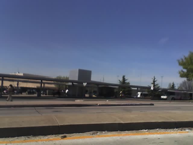
 The Mondawmin Metro Subway Station
- Mondawmin Mall, a 500,000 sq ft (46,000 m2). shopping center featuring a full service grocery store, and over 100 stores and shops
- Mondawmin Transit Hub: The second largerst transit hub in Baltimore City with access to Metro Subway and over 9 bus routes
- Baltimore City MVA, located at Mondawmin Mall
- Easterwood Park and Recreation Center
- Hanlon Park
- Parkwood Recreation Center
- Bon Secours Liberty Village, a comprehensive health care center with residential complex for senior citizens
Within walking distance is Druid Hill Park, which includes basketball and tennis courts; Druid Hill Conservatory and the Maryland Zoo; and Lafayette Market.
Nearby professional and college institutions include Urban Medical Institute, Coppin State University, and one of two campuses of Baltimore City Community College. The neighborhood is five minutes by car from the nearest light rail station; the area is also served by the Maryland Transit Administration's Mondawmin Shuttle Bug bus, and is exploring a more comprehensive regional shuttle system.
Housing stock
Most of the neighborhood's residential areas consist of brick rowhouses. Those built before World War II have large front porches and in some cases Victorian styling. Those built after the war tend to be two-story brick structures on wider lots than found in the inner city. A few single dwellings near the Walbrook neighborhood reflect their origins as summer homes built in the early 20th century.
History
The area was estate countryside in the 19th century, characterized by large homes built by prominent city residents on the hilly countryside several hundred feet above the Inner Harbor area. Mondawmin takes its name from the estate owned by Dr. Patrick Macaulay (1795–1849), physician, city councilman, B&O Railroad director and patron of the arts. Tradition relates that Henry Wadsworth Longfellow visited Dr. Macaulay, who asked him what to name his home, then surrounded by corn fields. The poet allegedly looked around and replied, "Why not Mondamin, after the Indian corn god?" (Mapmakers later added a "w" to the name, and it stuck.)
The area known as Southern Mondawmin prides itself on a long history of stable homeownership. Many residents moved into the community in the late forties and early fifties as the area developed as the cultural and education center for African Americans. Robert W. Coleman, one of the community's renowned residents, established the first school for the blind for African Americans. Because of those early pioneers and the stability of the community, Southern Mondawmin was never designated as an urban renewal area.
While the community has changed over the past 15 years, residents, churches, businesses, and community associations are diligently working to return the area to its early luster. Recently, Southern Mondawmin was chosen by Baltimore city's government as one of six Healthy Neighborhoods. Parts of the community are included as part of the empowerment zone. Mondawmin still has many blighted areas.
Schools
- Coppin State University
- Baltimore City Community College
- Frederick Douglass High School
- William H. Lemmel Middle School
- Gwynns Falls Elementary
- Robert W. Coleman Elementary
- William S. Baer Elementary
- Mathew Henson Elementary School
- Carver High School
- Walbrook High School
- George G. Kelson Elementary/Middle School
- Westside Elementary School
Students living in Mondawmin can also attend Baltimore City's elite public high schools, such as the nearby Western High School and Baltimore Polytechnic Institute.
Library Branch
- Enoch Pratt Free Library - Penn North
External links
- Healthy Neighborhoods: Mondawmin
- Mondawmin Mall
- Coppin State University
- Baltimore City Community College
Neighborhoods in Baltimore, Maryland Northwest Arlington • Ashburton • Cheswolde • Fallstaff • Forest Park • Glen • Howard • Park Heights • Pimlico • Reisterstown Station • Television Hill
North Abell • Barclay • Bellona-Gittings • Better Waverly • Cameron • Charles Village • Cedarcroft • Chinquapin Park-Belvedere • Cylburn • Edgecomb • Evergreen • Govans • Guilford • Hampden • Harwood • Homeland • Homewood • Keswick • Lake Evesham • Lake Walker • Little Korea Town • Medfield • Mount Washington • Oakenshawe • Pen Lucy • Poplar Hill • Radnor-Winston • Remington • Roland Park • Sabina Mattefeldt • Tuscany-Canterbury • Village of Cross Keys • Waverly • Woodberry • Wyman Park • Wyndhurst
Northeast Belair-Edison • Cedonia • Coldstream-Homestead-Montebello • Ednor Gardens-Lakeside • Frankford • Gardenville • Hamilton • Hillen • Lauraville • Loch Raven • Mayfield • Mid-Govans • Northwood • Ramblewood • Stonewood-Pentwood-Winston • Wilson Park • Woodbourne Heights
West Bridgeview/Greenlawn • Coppin Heights • Edmondson • Franklin Square • Harlem Park • Lexington • Mondawmin • Mosher • Poppleton • Rosemont • Sandtown - Winchester • Upton •
Walbrook • Windsor HillsCentral Barre Circle • Bolton Hill • Charles Center • Downtown • Inner Harbor • Madison Park • Mount Vernon • Otterbein • Reservoir Hill • Ridgely's Delight • Seton Hill • Station North • Westside
East Barclay • Berea • Broadway East • Coldstream-Homestead-Montebello • East Baltimore Midway • Ellwood Park • Four By Four • Greenmount West • Madison-Eastend • McElderry Park • Middle East • Oldtown-Latrobe • Oliver • Orangeville
Southwest Beechfield • Carrollton Ridge • Dickeyville • Franklintown • Gwynn's Falls • Hollins Market • Irvington • Morrell Park • Pigtown • Sowebo • Ten Hills • Union Square • Violetville • Wakefield • Washington Village • Yale Heights
South Brooklyn • Cherry Hill • Curtis Bay • Fairfield • Federal Hill • Harborview • Lakeland • Locust Point • Mount Winans • Pratt Monroe • South Baltimore • Wagner's Point • Westport
Southeast Bayview • Brewer's Hill • Butchers Hill • Canton • Fell's Point • Graceland Park • Greektown • Harbor East • Highlandtown • Jonestown • Joseph Lee • Kresson • Linwood • Little Italy • Patterson Park • St Helena • Upper Fells Point • Washington Hill
Public housing Allendale • Armistead Gardens • Bel Park Towers • Claremont • Douglass Homes • Ellerslie Homes • Flaghouse Homes • Govans Manor Homes • Heritage Crossing • Johnston Square • Lafayette Court • Latrobe Homes • Mason Homes • Lakeview Towers • McCulloh Homes • O'Donnell Heights • Perkins Homes • Pleasent View Gardens • Poe Homes • Primrose Place • Somerset Courts
Parks Clifton Park • Cylburn Arboretum • Druid Hill Park • Gwynns Falls Park • Leakin Park • Patterson Park • Sherwood Gardens • Wyman Park
Categories:- Neighborhoods in Baltimore, Maryland
- Populated places in Maryland with African American majority populations
Wikimedia Foundation. 2010.