- Mosher, Baltimore
-
Mosher is a neighborhood in the western part of Baltimore, Maryland. Its boundaries are the north side of Edmondson Avenue, the west side of Braddish Avenue, the east side of Poplar Grove, and the south side of Riggs Avenue. The neighborhood lies in the vicinity of Walbrook Junction, Coppin State University, Sandtown-Winchester, and Edmondson Village. Mosher is one of several neighborhoods that resisted the development of the "Road to Nowhere", now designated as US 40, along the Franklin Avenue corridor. The area was historically segregated, and largely occupied by European Americans, but transitioned during the early 1950s to become a predominantly African American area.
 Hebrew Orphan Asylum, Baltimore
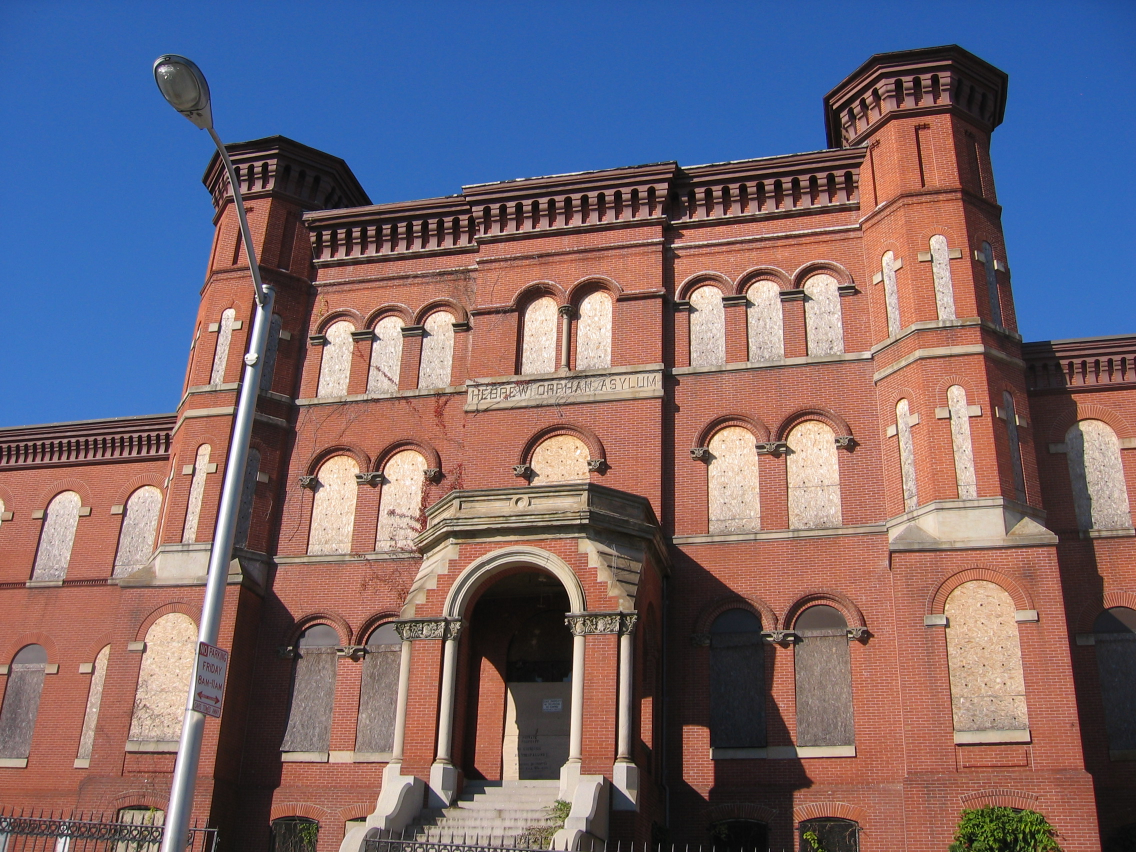
One of the most significant buildings remaining the early development of Mosher is the Hebrew Orphan Asylum. This 1876 Richardsonian Romanesque building became the West Baltimore General Hospital in 1923, then in 1945 became the Lutheran Hospital of Maryland. The hospital closed in 1989 and the building has been owned by Coppin State University since 2003.
The population neighborhood is predominantly African American and significantly low-income. According to 2000 Census data, 99% of Mosher households identify as African-American, .5% identifying as Asian, and .2% each identifying as white, American Indian and Alaska Native, or two or more races. The median household income was $24,667. Resident organizations in Mosher include the La Burt Improvement Association, Lafayette Community Association, Mosher Ridge Improvement Association, and Nehemiah House Community Association.
External links
Neighborhoods in Baltimore, Maryland Northwest Arlington • Ashburton • Cheswolde • Fallstaff • Forest Park • Glen • Howard • Park Heights • Pimlico • Reisterstown Station • Television Hill
North Abell • Barclay • Bellona-Gittings • Better Waverly • Cameron • Charles Village • Cedarcroft • Chinquapin Park-Belvedere • Cylburn • Edgecomb • Evergreen • Govans • Guilford • Hampden • Harwood • Homeland • Homewood • Keswick • Lake Evesham • Lake Walker • Little Korea Town • Medfield • Mount Washington • Oakenshawe • Pen Lucy • Poplar Hill • Radnor-Winston • Remington • Roland Park • Sabina Mattefeldt • Tuscany-Canterbury • Village of Cross Keys • Waverly • Woodberry • Wyman Park • Wyndhurst
Northeast Belair-Edison • Cedonia • Coldstream-Homestead-Montebello • Ednor Gardens-Lakeside • Frankford • Gardenville • Hamilton • Hillen • Lauraville • Loch Raven • Mayfield • Mid-Govans • Northwood • Ramblewood • Stonewood-Pentwood-Winston • Wilson Park • Woodbourne Heights
West Bridgeview/Greenlawn • Coppin Heights • Edmondson • Franklin Square • Harlem Park • Lexington • Mondawmin • Mosher • Poppleton • Rosemont • Sandtown - Winchester • Upton •
Walbrook • Windsor HillsCentral Barre Circle • Bolton Hill • Charles Center • Downtown • Inner Harbor • Madison Park • Mount Vernon • Otterbein • Reservoir Hill • Ridgely's Delight • Seton Hill • Station North • Westside
East Barclay • Berea • Broadway East • Coldstream-Homestead-Montebello • East Baltimore Midway • Ellwood Park • Four By Four • Greenmount West • Madison-Eastend • McElderry Park • Middle East • Oldtown-Latrobe • Oliver • Orangeville
Southwest Beechfield • Carrollton Ridge • Dickeyville • Franklintown • Gwynn's Falls • Hollins Market • Irvington • Morrell Park • Pigtown • Sowebo • Ten Hills • Union Square • Violetville • Wakefield • Washington Village • Yale Heights
South Brooklyn • Cherry Hill • Curtis Bay • Fairfield • Federal Hill • Harborview • Lakeland • Locust Point • Mount Winans • Pratt Monroe • South Baltimore • Wagner's Point • Westport
Southeast Bayview • Brewer's Hill • Butchers Hill • Canton • Fell's Point • Graceland Park • Greektown • Harbor East • Highlandtown • Jonestown • Joseph Lee • Kresson • Linwood • Little Italy • Patterson Park • St Helena • Upper Fells Point • Washington Hill
Public housing Allendale • Armistead Gardens • Bel Park Towers • Claremont • Douglass Homes • Ellerslie Homes • Flaghouse Homes • Govans Manor Homes • Heritage Crossing • Johnston Square • Lafayette Court • Latrobe Homes • Mason Homes • Lakeview Towers • McCulloh Homes • O'Donnell Heights • Perkins Homes • Pleasent View Gardens • Poe Homes • Primrose Place • Somerset Courts
Parks Clifton Park • Cylburn Arboretum • Druid Hill Park • Gwynns Falls Park • Leakin Park • Patterson Park • Sherwood Gardens • Wyman Park
Categories:- Neighborhoods in Baltimore, Maryland
- Populated places in Maryland with African American majority populations
- Maryland geography stubs
Wikimedia Foundation. 2010.