- Medfield, Baltimore
-
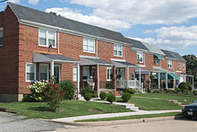 Houses along Newport Avenue, August 2011
Medfield is a neighborhood located in north Baltimore, Maryland, United States of America. It is located to the north of the trendy Hampden neighborhood and south of affluent Roland Park neighborhood. Its unofficial boundaries are Coldspring Lane to the north; Jones Falls Expressway (Interstate 83) to the west; Falls Road/Hickory Avenue to the east; and West 41st Street to the south.
Contents
History
Most of Medfield was developed from the 1920s through the 1960s. The southern section of the neighborhood (that adjacent to Hampden) and the northern section (off of Cold Spring Lane) were the first areas to be developed. The middle was developed from the 1940s - 1950s. Many of the first residents of Medfield were longtime residents of Hampden, who wished to move into newer houses, some of which had larger yards. Many of such residents still refer to the area as "Lower Roland Park".
Despite the suburban flight and subsequent urban decay experienced in Baltimore starting in the 1950s, Medfield continued to be a desirable and comparatively safe neighborhood for blue-collar and middle-class families. As a result of urban renewal efforts and the "boom" in the housing market experienced in the 2000s, the neighborhood received much investment and rehabilitation, and thus attracted an increased amount of young professionals. There are currently several development projects still planned for the neighborhood.
Housing stock
Medfield contains a variety of types of houses, far more variety than most Baltimore neighborhoods. Most of the neighborhood consists of brick rowhomes, most of which include front porches. There are also many single-family detached houses throughout the neighborhood, as well as several apartment buildings.
Schools
Medfield is home to Medfield Heights Elementary School, which boasts test scores above city/state averages. The neighborhood is also adjacent to the campuses of Baltimore Polytechnic Institute and Western High School, 2 well-regarded public magnet schools.
The community is also about 1 mile from Loyola College and about 2 miles from Johns Hopkins University Homewood Campus.
Parks
Medfield Heights Park is located directly behind Medfield Heights Elementary School, and is overseen by the Principal of the Elementary School. This park contains 2 baseball fields, basketball courts, and green space. The neighborhood is also walking distance to several parks in Hampden (Roosevelt Park on Falls Road and W. 36th Street; and a playground on West 42nd Street at Buena Vista Avenue). It is also about 2 miles from Robert E. Lee Park in Baltimore County.
Transportation
Medfield is easily accessible by many methods of transportation. The community is located directly off of Exit 9 of the Jones Falls Expressway (I-83), and is walking distance from the Cold Spring Lane station of the Baltimore Light Rail. Nearby bus lines include the #27 (Falls Road), #33 (Cold Spring Lane), #22 (W. 41st Street), and #98 (Hampden Shuttle).
Neighborhoods in Baltimore, Maryland Northwest Arlington • Ashburton • Cheswolde • Fallstaff • Forest Park • Glen • Howard • Park Heights • Pimlico • Reisterstown Station • Television Hill
North Abell • Barclay • Bellona-Gittings • Better Waverly • Cameron • Charles Village • Cedarcroft • Chinquapin Park-Belvedere • Cylburn • Edgecomb • Evergreen • Govans • Guilford • Hampden • Harwood • Homeland • Homewood • Keswick • Lake Evesham • Lake Walker • Little Korea Town • Medfield • Mount Washington • Oakenshawe • Pen Lucy • Poplar Hill • Radnor-Winston • Remington • Roland Park • Sabina Mattefeldt • Tuscany-Canterbury • Village of Cross Keys • Waverly • Woodberry • Wyman Park • Wyndhurst
Northeast Belair-Edison • Cedonia • Coldstream-Homestead-Montebello • Ednor Gardens-Lakeside • Frankford • Gardenville • Hamilton • Hillen • Lauraville • Loch Raven • Mayfield • Mid-Govans • Northwood • Ramblewood • Stonewood-Pentwood-Winston • Wilson Park • Woodbourne Heights
West Bridgeview/Greenlawn • Coppin Heights • Edmondson • Franklin Square • Harlem Park • Lexington • Mondawmin • Mosher • Poppleton • Rosemont • Sandtown - Winchester • Upton •
Walbrook • Windsor HillsCentral Barre Circle • Bolton Hill • Charles Center • Downtown • Inner Harbor • Madison Park • Mount Vernon • Otterbein • Reservoir Hill • Ridgely's Delight • Seton Hill • Station North • Westside
East Barclay • Berea • Broadway East • Coldstream-Homestead-Montebello • East Baltimore Midway • Ellwood Park • Four By Four • Greenmount West • Madison-Eastend • McElderry Park • Middle East • Oldtown-Latrobe • Oliver • Orangeville
Southwest Beechfield • Carrollton Ridge • Dickeyville • Franklintown • Gwynn's Falls • Hollins Market • Irvington • Morrell Park • Pigtown • Sowebo • Ten Hills • Union Square • Violetville • Wakefield • Washington Village • Yale Heights
South Brooklyn • Cherry Hill • Curtis Bay • Fairfield • Federal Hill • Harborview • Lakeland • Locust Point • Mount Winans • Pratt Monroe • South Baltimore • Wagner's Point • Westport
Southeast Bayview • Brewer's Hill • Butchers Hill • Canton • Fell's Point • Graceland Park • Greektown • Harbor East • Highlandtown • Jonestown • Joseph Lee • Kresson • Linwood • Little Italy • Patterson Park • St Helena • Upper Fells Point • Washington Hill
Public housing Allendale • Armistead Gardens • Bel Park Towers • Claremont • Douglass Homes • Ellerslie Homes • Flaghouse Homes • Govans Manor Homes • Heritage Crossing • Johnston Square • Lafayette Court • Latrobe Homes • Mason Homes • Lakeview Towers • McCulloh Homes • O'Donnell Heights • Perkins Homes • Pleasent View Gardens • Poe Homes • Primrose Place • Somerset Courts
Parks Clifton Park • Cylburn Arboretum • Druid Hill Park • Gwynns Falls Park • Leakin Park • Patterson Park • Sherwood Gardens • Wyman Park
Categories:- Neighborhoods in Baltimore, Maryland
- Maryland geography stubs

Wikimedia Foundation. 2010.