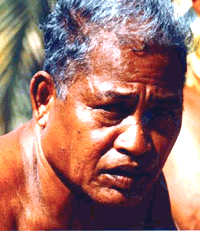
- Mau Piailug
-
Mau Piailug 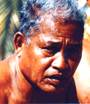
Born Pius Piailug
1932
Weiso, Satawal, Yap, Federated States of MicronesiaDied July 12, 2010 (aged 78)
Satawal, Yap, Federated States of MicronesiaCause of death Complications of diabetes Nationality Micronesian Other names Mau, Papa Mau Ethnicity Satawalese Education Weriyeng school of navigation Occupation Navigator, canoe builder, teacher (kumu) Years active 1948–2007 Known for Wayfinding, Polynesian navigation, Hawaiian Renaissance Influenced by Raangipi (grandfather), Angora (uncle) Influenced Nainoa Thompson Spouse Nemwaeito (alt. sp. Nemoito) Children 16 Parents Orranipui (father) Relatives Urupoa (brother) Awards Special fellowship, East-West Center (1976)
Honorary Doctor of Humane Letters, UH (1987)
Robert J. Pfeiffer Medal (2008)Pius "Mau" Piailug (pronounced /ˈpaɪəs ˈmaʊ piːˈaɪləɡ/; 1932 – July 12, 2010) was a Micronesian navigator from the Carolinian island of Satawal, best known as a teacher of traditional, non-instrument wayfinding methods for deep-sea voyaging. Mau's Carolinian navigation system—which relies on navigational clues using the sun and stars, winds and clouds, seas and swells, and birds and fish—was acquired through rote learning passed down through teachings in the oral tradition. He earned the title of master navigator (palu) by the age of eighteen, around the time the first American missionaries arrived in Satawal. As he neared middle age, Mau grew concerned that the practice of navigation in Satawal would disappear as his people became acculturated to Western values. In the hope that the navigational tradition would be preserved for future generations, Mau shared his knowledge with the Polynesian Voyaging Society (PVS). With Mau's help, PVS used experimental archaeology to recreate and test lost Hawaiian navigational techniques on the Hōkūle‘a, a modern reconstruction of a double-hulled Hawaiian voyaging canoe.
The successful, non-instrument sailing of Hōkūle‘a to Tahiti in 1976, proved the efficacy of Mau's navigational system to the world. To academia, Mau's achievement provided evidence for intentional two-way voyaging throughout Oceania, supporting a hypothesis that explained the Asiatic origin of Polynesians. The success of the Micronesian-Polynesian cultural exchange, symbolized by Hōkūle‘a, had an impact throughout the Pacific. It contributed to the emergence of the second Hawaiian cultural renaissance and to a revival of Polynesian navigation and canoe building in Hawaii, New Zealand, Rarotonga and Tahiti. It also sparked interest in traditional wayfinding on Mau's home island of Satawal. Later in life, Mau was respectfully known as a grandmaster navigator, and he was called "Papa Mau" by his friends with great reverence and affection. He received an honorary degree from the University of Hawaii, and he was honored by the Smithsonian Institution and the Bishop Museum for his contributions to maritime history. Mau's life and work was explored in several books and documentary films, and his legacy continues to be remembered and celebrated by the indigenous peoples of Oceania.
Contents
Early life (1932–1974)
Satawal, Micronesia
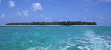
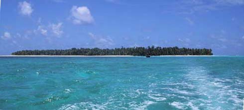
Mau was born Pius Piailug in 1932, in the village of Weiso on the small coral island of Satawal, in Yap State of the Caroline Islands, a part of the Federated States of Micronesia.[1] Satawal is a wooded island with an area of 1.3 square kilometres (0.50 sq mi), located in the Western Pacific Ocean about 800 kilometres (500 mi) south of Guam. Mau's personal connection to the sea began early in his life, when he was placed in tide pools in his infancy so he could feel the pull of the ocean.[2] At the age of four or five, Mau was chosen by his grandfather Raangipi to study as an apprentice navigator.[3] Mau initially protested his grandfather's teaching, preferring to spend his time playing on the beach with children his own age. Raangipi trained Mau as a young navigator for many years. Their day would begin at sunrise, when they would eat breakfast together and afterwards, take care of chores before going fishing. During the evening, Mau would join the men in the canoe house as they drank, listening to their stories about navigation and sailing. Raangipi told the young boy that if he chose to become a navigator, Mau could gain respect from his community, eat well, and maintain a position in Satawalese society higher than that of a chief. Encouraged, Mau learned basic navigational clues regarding the "stars, swells, and birds" from Raangipi, but his grandfather died sometime before Mau was fourteen.[4]
After his grandfather died, Mau began training with his father, Orranipui. Mau learned more about navigating by stars (wofanu) from his father, and how to fish and build canoes. When his father died before he turned fifteen,[5] Mau was adopted by his aunt and uncle. Sometime around the age of eighteen,[6] Mau's aunt and uncle sent him to study with Angora, an acclaimed navigator.[7] His studies culminated in his initiation as a master navigator (palu) in the Weriyeng school of navigation[8] during the revered pwo ceremony presided over by Angora. It was to be the last pwo held on Satawal for the next fifty years. After the ceremony, Mau lived for a month in the canoe house where he received rigorous lessons from three navigators.[9] When the final training was complete, Mau made his first solo voyage of about 92 kilometres (57 mi).[10] Because he had a tendency to sail in all weather conditions, he was given the nickname "Mau", from the Satawalese word maumau, meaning "strong".[11] After becoming a navigator, Mau married Nemwaeito[12] with whom he raised ten boys and six girls.[13]
 "Mau Piailug is from the island of Satawal. It's a mile and a half long and a mile wide. Population 600. Navigation's not about cultural revival, it's about survival. Not enough food can be produced on a small island like that. Their navigators have to go out to sea to catch fish so they can eat." — Nainoa Thompson[14]
Daily life in Mau's village on Satawal involved harvesting taro and gathering breadfruit and coconut. The Satawalese people also raised chicken and pork[15] and caught fish, their primary source of protein.[14] A freshwater pond served as bathing facilities. Local materials were used to construct outrigger canoes called proa. The island's isolation helped preserve the lifestyle of the Satawalese people and Mau's role as a navigator.[16] Even with the arrival of the Germans (1890) and the Japanese (1914) in Micronesia, Satawalese culture remained intact. American missionaries who arrived after World War II[17] built the first church and school on Satawal.[18]
In the late 1960s, Mau attempted to verify his navigational knowledge of the wider Pacific by working as a seaman on an inter-island ship run by the Trust Territory of the Pacific Islands.[19] From 1969–1973, Mau became friends with Mike McCoy, a Peace Corps volunteer stationed on Satawal.[20] As well as marrying Mau's niece, McCoy sailed with Mau and they worked together on a project tagging turtles. McCoy became interested in Satawalese navigation, published several articles on the topic and kept in touch with the anthropologist Ben Finney, who was researching Polynesian navigation. When McCoy's assignment on Satawal ended, he asked Pialug if he wanted to come to Hawaii with him.[21]
Honolulu, Hawaii
Mau first visited Hawaii in 1973, and McCoy introduced him to Ben Finney. Later, Finney suggested to the Polynesian Voyaging Society that they should try to recruit Mau for their Hōkūle‘a project,[3] since no Hawaiian traditional navigators remained. The project goal was to test the hypothesis that Polynesians made intentional non-instrument voyages across the Pacific. Tevake, a renowned Polynesian navigator, had died in 1970[22] and only six others were known.[23] Navigators were reluctant to release their sacred knowledge to "outsiders."[24] At the time, Mau was just forty-one years old, and the youngest navigator out of the group. Mau feared that traditional navigation would die in his own culture, just as it had in Hawaii. He had tried to teach the young men of Satawal the skills passed on to him, but he was not optimistic. The members of the younger generation were too busy with school and too attracted to Western culture to undertake the rigorous course of study and apprenticeship. Further, Mau's people did not seem to care that traditional navigation was dying, and could be lost forever.[25]
Later life (1975–2010)
Hōkūle‘a
With Finney's help, Mau was awarded a special fellowship at the East-West Center.[26] Mau returned to Honolulu in April 1975 to begin work with the Hawaii-based Polynesian Voyaging Society, eventually navigating the double-hulled canoe, Hōkūle‘a, from Hawaii to Tahiti on its maiden voyage in 1976.[27] Mau trained and mentored Native Hawaiian navigator Nainoa Thompson, who later would become a master navigator.[28] David Henry Lewis, a scholar of Polynesian navigation, documented Mau's work.[29]
Mau Piailug's Voyages on Hōkūle‘a Hōkūle‘a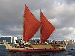
Year Voyage Ports 1976 Inaugural Voyage Hawaii–Tahiti 1980 Tahiti Voyage Hawaii–Tahiti–Hawaii 1985–
1987Voyage of Rediscovery Hawaii–Tahiti–Rarotonga;
Waitangi–Nuku‘alofa–Pago Pago–Tutuila–Aitutaki–Rarotonga–Tautira1995 Nā ʻOhana Holo Moana Hilo–Pape‘ete; Nuku Hiva–Hilo Mau's first-hand knowledge of traditional navigation had been accumulated in northern hemisphere study and sailings, but the voyage to Tahiti required Mau to familiarize himself with the geography and night sky of the southern hemisphere. Of this preparation, Finney writes,
...To prepare Mau Piailug for the voyage, David Lewis briefed him on the geography of the islands in this part of the Pacific and the winds and currents that could be expected along the way, all information that an early Polynesian navigator acquainted with this route would have carried in his head. In addition, to alert Mau of how the elevation of stars above the northern and southern horizons would change as the canoe sailed farther and farther south, we held training sessions in Honolulu's Bishop Museum planetarium to graphically show how, for example, as one sailed toward Tahiti[,] Polaris sank lower and lower on the northern horizon until it disappeared at the equator while the Southern Cross curved higher and higher in the sky. During his first few days of the voyage, Mau received further coaching on the pattern of winds and currents from Rodo Williams, a veteran Tahitian seaman on the crew who the year before had sailed a yacht from Tahiti to Hawaii and could therefore provide Mau with a firsthand account of what he could expect to encounter.[30]
Their collaboration proved successful when, on the thirtieth day at sea on the 1976 voyage, Mau stated soon they would see land, and the next day, Tahiti. A few hours later, they spotted land-based white terns (Gygis alba) followed by a diminution of the trade-wind swell. That night they spotted Mataiva. After a brief stopover, with little more than another day's sailing they made landfall at Tahiti where they were welcomed by 17,000 people—half the population of Tahiti.[31]
Nainoa's ambition was to sail Hōkūle‘a to Tahiti as navigator using recreated traditional techniques. He spent years training on his own and with Mau. Mau's training and mentoring helped Nainoa achieve that goal in the 1980 Tahiti voyage. It marked the first time in over 500 years that a Native Hawaiian had mastered the stars, the seas, the birds, and the winds to guide a sailing canoe from Hawaii to Tahiti and back.[32] The two men joined again for the 1985–1987 Voyage of Rediscovery to New Zealand, again with Nainoa as principal navigator and Mau as mentor. The voyage to New Zealand stoked Māori interest in cultural history, navigation techniques, and canoe building.[33] It also brought to life for Māori the stories in their folklore of the great canoe voyages of migration and settlement in Aotearoa (New Zealand). Describing a ceremony held at Waitangi to commemorate the Hawaii–New Zealand voyage of Hōkūle‘a, Nainoa writes:
Sir James Henare, the most revered of the elders of Tai Tokerau, got up and said, "You've proven that it could be done. And you've also proven that our ancestors did it. ... because the five tribes of Tai Tokerau trace their ancestry from the names of the canoes they arrived in, and because you people from Hawai'i came by canoe, therefore by our traditions, you must be the sixth tribe of Tai Tokerau.[34]
In 1995, Mau took part in the Nā ʻOhana Holo Moana voyage of Hōkūle‘a to Ra‘iātea. Sailing with his son Sesario Sewralur, and Nainoa as sailing master, Mau watched as Nainoa's students Kaʻau McKenney and Keahi Omai served as navigators. Mau had seen Nainoa succeed in the 1980 and 1985–1987 voyages; finally, in this 1995 voyage, Mau saw proof that the knowledge was carried forward to the next generation.[35] The canoe not only landed successfully at Rarotonga, but the voyage resulted in the lifting of a six-centuries-old taboo on voyaging from Ra‘iātea.[36][37] Hōkūle‘a had sailed from Hawaii with sisterships Hawai‘iloa and Makali‘i; these canoes rendezvoused at Taputapuatea with other voyaging canoes from across Oceania.[36]
Makali‘i
To help preserve Hawaiian culture, Milton "Shorty" Bertelmann and his brother Clay established the nonprofit organization, Nā Kalai Wa‘a Moku o Hawai‘i on the island of Hawaii in 1992. Beginning in 1994, the two brothers helped construct Makali‘i, a 54-foot voyaging canoe, launching it in 1995. From February to May, 1999, "Shorty" Bertelmann navigated Makali‘i to Satawal in a voyage known as “E Mau – Sailing the Master Home.” This voyage was to pay homage to master navigator Mau Piailug and to thank him for his teachings. Mau sailed home aboard Makali‘i as their honored guest. Makali‘i continued her 1999 voyage through half the length of Micronesia. She was the first Hawaiian voyaging canoe to visit the far reaches of Micronesia and her appearance stimulated interest amongst Micronesians in their own cultural history.[38]
Alingano Maisu
On March 18, 2007 Mau presided over the first pwo ceremony for navigators in fifty-six years on the island of Satawal. Five Native Hawaiians and eleven other people were inducted into pwo as master navigators, including Nainoa Thompson and Mau's son Sesario Sewralur. The Polynesian Voyaging Society, as part of the 2007 Hōkūle‘a "One Ocean, One People" voyage named "Kū Holo Mau," presented Mau with a canoe named the Alingano Maisu—a gift for his key role in reviving traditional wayfinding navigation in Hawaii. The canoe was built in Kawaihae, Hawaii under the nonprofit organization Nā Kalai Wa‘a Moku O Hawai‘i. The commitment to build this "gift" for Mau was made by Clay Bertelmann, captain of Makali‘i and Hōkūle‘a. Maisu was given to Mau on behalf of all the voyaging families and organizations that actively continue to sail and practice the traditions taught by Mau Piailug.[39]
Death
After a long struggle with diabetes, Mau died on his home island of Satawal at 6:30 p.m. Micronesia time,[40] Monday, July 12, 2010.[41] As is the tradition on Satawal, travel between the islands was temporarily suspended in Mau's honor.[42] Because there is no morgue on the island Mau was buried the following day, and a nightly rosary was held until the memorial service on July 21 at Santa Soledad Church. Mau's son Henry Yarofalpiy will continue teaching students about their culture, preserving the legacy of his father.[42]
Awards
Mau was awarded an honorary Doctor of Humane Letters in 1987 by the University of Hawaii.[43] On May 9, 2000, he was honored by the Smithsonian Institution at the National Museum of Natural History. At the ceremony, then-secretary Lawrence Small said, "The rebirth of non-instrument navigation came about largely due to this man, Mau Piailug."[44] The Bishop Museum presented Mau with the Robert J. Pfeiffer Medal on July 12, 2008, honoring him for "exceptional dedication to the advancement of maritime affairs and the perpetuation of maritime heritage in Hawaii and the Pacific." Mau also was honored for his "devotion and outstanding civic leadership" and for exemplifying "the spirit and purpose of the Museum's founder Charles Reed Bishop".[45]
Legacy
The success of Mau's navigational feats sparked cultural pride in Tahitians, Māori and Hawaiians and connected all Polynesians to stories their forebears told of similar voyages of generations past. The voyage of Hōkūle‘a attracted the interest of young students such as Milton "Shorty" Bertelmann and later Nainoa Thompson.[46] Mau not only led Hōkūle‘a to Tahiti, but reconnected the people of the Pacific to their cultural roots. Revived interest in preserving traditional culture and navigation methods reinvigorated the art of canoe building and cultural studies in Hawaii, New Zealand, Rarotonga, and Tahiti,[47] as well as Mau's homeland of Satawal.[42]
Two centuries before Mau and the Hōkūle‘a, Captain James Cook, with the help of Tupaia,[48] gained knowledge that otherwise would have been closely held. Before his death in 1779, Cook hypothesized that Polynesians shared common ancestry; he even pinned their origin to Asia. However, Cook's theory did not prevent debate among scholars. Before the Hōkūle‘a voyage in 1976, academic debate about the settlement of Polynesia was divided between several schools of thought.[49]
Norwegian ethnographer Thor Heyerdahl hypothesized that the Pacific was settled by voyages from South America and set out to prove this with his Kon-Tiki expedition.[50] Scholars did not take Heyerdahl's hypothesis seriously. New Zealander Andrew Sharp proposed the accidental voyaging hypothesis in 1957 which argued that Oceania was too vast to have been settled by intentional voyaging, so migrations must have happened by accidental drift voyages.[51] Sharp granted that Polynesians did likely settle the Pacific from Asia, but held the opinion that their crude vessels and navigational tools were no match for intentional sailing from Tahiti to Hawaii or New Zealand. He stated that voyages of more than three hundred miles were likely accidental voyages, with landfall at the mercy of wind and current.[52] A 1973 study and computer simulation by Levison, Ward, and Web investigated the probability of Sharp's hypothesis, but found it improbable.[53]
Finney disagreed with the accidental voyaging portion of Sharp's hypothesis. To investigate the problem he founded the Polynesian Voyaging Society with Herb Kane and Tommy Holmes in 1973, intent on building a voyaging canoe to sail from Hawaii to Tahiti to test whether intentional two-way voyaging throughout Oceania could be replicated.[54] With the help of Mau's navigational knowledge guiding Hōkūle‘a, the Polynesian Voyaging Society demonstrated that intentional voyaging was not only possible, but that the ancestors of the Polynesians could have settled the Pacific on similar voyages using non-instrument wayfinding techniques such as Mau's.[55] Finally, linguistic[56] and archaeological evidence suggests that the history of the Polynesian people does not originate in the east, but in the west.[57] Recent developments in the field of DNA analysis have unequivocally settled the debate of Polynesian origin. They prove Polynesians share common ancestry with indigenous Taiwanese and East Asians.[58]
Training
Navigator training was historically interwoven with culture and ritual. Great discretion had to be shown in candidate selection so that the knowledge preserved through oral tradition would have the greatest chance of survival. A master navigator's rank was equal or superior to a village chief's rank. Prudent navigation relies on no single technique, but instead synthesizes position from multiple inputs. Underway, this constant synthesis makes it easy to spot the navigator—he's the one with red eyes from sleep deprivation.[59]
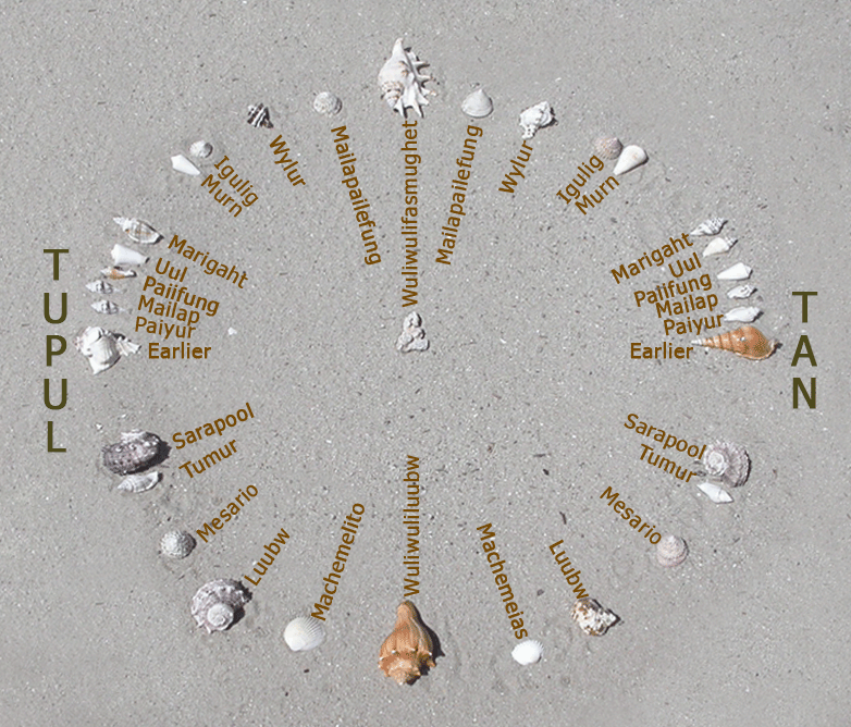
Mau Piailug's Star Compass[60] 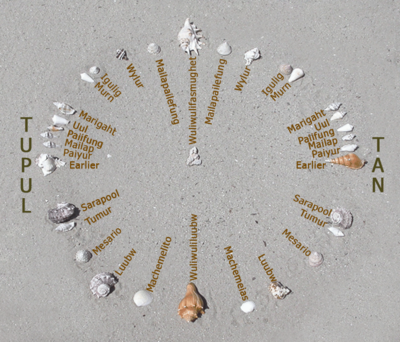
Used only to train navigators, the star compass is not
carried aboard boats. Shown North up.Legend Satawalese name Traditional name Astronomical name Tupul Setting n/a Tan Rising n/a Wuliwulifasmughet North star Polaris Mailapailefung Little Dipper Ursa Minor Wylur Big Dipper Ursa Major Igulig ("Whale") 1) Cassiopeia (head of whale)
2a) Almach &
2b) Mirach (body of whale)
3a) Hamal &
3b) Sharatan (whale's tail)1) Cassiopeia
2a) Gamma Andromedae &
2b) Beta Andromedae
3a) Alpha Arietis &
3b) Beta ArietisMurn Vega Vega Marigaht Seven Sisters Pleiades Uul Aldebaran Alpha Tauri Paiifung Tarazed Gamma Aquilae Mailap Altair Alpha Aquilae Paiyur Alshain Beta Aquilae Earlier Orion Orion Sarapool Corvus Corvus Tumur Scorpius (Top 6 stars) Scorpius Mesario 1a) Shaula &
1b) Antares1a) Lambda Scorpii &
1b) Alpha ScorpiiLuubw Southern Cross
(rising or setting)Crux Machemeias Southern Cross
(at 45° over SE horizon)Crux Wuliwuliluubw Southern Cross
(upright)Crux Machemelito Southern Cross
(at 45° over SW horizon)Crux For a traditionally trained navigator, these inputs include physical signals from the sea, skies, and stars, memory signals from his knowledge of star, swell, and wind compasses; and cultural knowledge recorded in chants, dances, and stories. Examples of physical signals include the color, temperature, and taste (salinity) of seawater; floating plant debris; sightings of land-based seabirds flying out to fish; cloud type, color, and movement; wind direction, speed, and temperature; the direction and nature of ocean swells and waves; the position of stars in the sky, and his estimation of the speed, current set, and leeway of his sailing craft. The "compass" he carried was not magnetic, but a mental model of where islands are located, and the star points which one could use to navigate between them. This mental model would have taken years of study to build; dances, chants (rong),[61] and stories help him to recall complex relationships of geography and location. The stars give him highly reliable position information when visible, but navigators such as Mau managed to keep their position and tracks in mind even when blocked by clouds, using other references such as wind and swell as proxies.[14]
Mau's Carolinian star compass (pictured) is the basis for Nainoa's modern Hawaiian star compass. Apart from the bulk of training which happens at sea, historically boys were taught in the men's house with pebbles, shells, or pieces of coral, representing stars, laid on the sand in a circular pattern. Which bits of shell or coral are chosen to represent which star or constellation is arbitrary, but generally, larger pieces are used for points of the compass while smaller pieces represent important stars between those points. In Mau's star compass, these points are not necessarily equidistant. The outer circular formation represents the horizon, with the canoe its center point. The eastern half of the circle depicts reference stars' rising points on the horizon while the western half depicts their setting points. Swell patterns of prevailing trade winds are represented by sticks (not depicted here) overlaying the star compass in the form of a square. All knowledge is retained by memory with the help of dances, chants, and stories, wherein the stars are enumerated as people or characters in the stories.[62]
Technique
One aspect of the Carolinian method of estimating longitude on inter-island sailings is to visualize the target island relative to a second reference island's alignment with a succession of selected stars, points of the star compass. This is a refined system of dead reckoning whereby the navigator constantly synthesizes his position relative to the reference island's location in his mental model. The most remarkable thing about this is that the reference island (lu pongank)[63] may be over the horizon, unseen, even imaginary.[64]
In its simplest form the star compass describes thirty-two points at which key stars rise on the eastern horizon and set on the western horizon. North latitude is fairly easy to determine because the North Pole has a zenith star easily seen with the naked eye, called Polaris (Wuliwulifasmughet).[65] Polaris' height above the horizon (declination) indicates the viewer's southward displacement from Polaris' nadir—the North Pole. Traveling further north, Polaris appears higher in the sky. Only at the true north pole is Polaris directly overhead at nearly 90 degrees declination.[66] Traveling south toward the equator, Polaris appears to descend toward the northern horizon. At 45 degrees north latitude, Polaris is 45 degrees above the northern horizon. Near the equator, Polaris' declination approaches zero degrees, but for the viewer just farther south, Polaris will have disappeared below the northern horizon.
Continuing south from the equator, though Polaris is no longer visible, Crux (Luubw),[65] the "Southern Cross," will have risen above the southern horizon. Traveling further southward, Crux rises higher in the sky. Through Crux's longest axis, an imaginary line bisecting Gacrux and Acrux points southward toward the southern celestial pole. But the South Pole has no true zenith star from which direct readings of south latitude may be taken. As a proxy, the southern celestial pole lies at the end of that imaginary line extended southward through Gacrux and Acrux, at a distance about 4.5 times the distance between them.[67] Nainoa Thompson notes that at Hawaiʻi's latitude, the distance between Gacrux and the southerly Acrux is equal to Acrux's declination above the southern horizon.[68]
To steer the canoe in mid-ocean on a consistent course, the navigator selects a star and keeps the canoe pointed toward it. Should it become cloud-blocked, or rise too high in the sky, he selects another star but offsets his reference to remain true to the first, or steers at the same relative angle to the swell as when steering toward the star.[69]
Notes
- ^ The New York Times 1995, p. A12 and Rosen 2008, Part One, Chapter 6, "Mau & His Brother".
- ^ The Economist 2010, p. 84 and Kawaharada 2010a, §5
- ^ a b Finney & Low 2007, p. 170.
- ^ Thomas 1987, pp. 117–119. Mau was between the ages of eleven and fourteen when his grandfather died.
- ^ Mau was between the ages of thirteen and fifteen when his father died.
- ^ Metzgar 1991, p. 231 Sources vary as to Mau's age at the time of his pwo initiation on Satawal. Lewis 1978, p. 134 suggests a time around 1950 and Thomas 1987, p. 118 between 1947 and 1948. Metzgar suggests that the years between 1950–1952 are more likely.
- ^ Thomas 1987, pp. 117-119.
- ^ Lewis 1978, p. 135 The Weriyeng navigation school is an ancient institution which began on Pollap Island many centuries ago. Weriyeng and the Fanur school are the only two schools of navigation left in Micronesia. Also see Woodward 1998, p. 470
- ^ Thomas 1987, pp. 118-119.
- ^ Rosen 2008, Part One, Chapter 4, "Talk Canoe", 20:27.
- ^ Ferrar 2006, p. 12 "The people on my island, they put my name as Mau because when I was young I no like stay long time on the land. When I come from the ocean, two or three days, then I go back again. Even when the storm is come, I still stay out on the ocean. That's why my people they call me Mau." According to Thomas (1987), Mau was named after the hawksbill turtle, known as mau in Satawalese; See Jaynes & Raffipiy 2010: According to Mau’s nephew, Tom Raffipiy: "In his native Satawalese vernacular "mau" means strong, strength, hard, hardened, and mature, among other definitions. Truly, Pius "Mau" Piailug lived up to the nickname given to him in his early adulthood. The name was supposedly given to him to describe his uncanny physique which was then thought of as a physical defect. The ripples of muscles on his back were likened to the rough shells of hawksbill turtles. However he got the nickname "Mau" one can be certain that it was given out of love and affection as was the normal practice. Probably no one realized how the name would shape the character of the man who defied cultural belief to safeguard a dying art of Oceania – non-instrumental navigation."
- ^ Also spelled Nemoito.
- ^ Thomas 1987, p. 45.
- ^ a b c Thompson 2007.
- ^ Fosberg 1969, p. 2.
- ^ Low 2011.
- ^ Mau's brother Urupoa believes the missionaries arrived or were established on Satawal sometime around 1948. See Rosen 2008, Event occurs at 29:13.
- ^ Rosen 2008, Part One, Chapter 6, "Mau & His Brother".
- ^ Finney 1979, p. 61.
- ^ Rosen 2008, Part One, Chapter 7, "Hokuleʻa Voyage - 1976".
- ^ Lewis 1994, pp. 335–336 and Kyselka 1987, p. 37
- ^ Gordon 2006, p. B1.
- ^ The Economist 2010, p. 84.
- ^ Lewis 1978, p. 134.
- ^ Finney 1979, pp. 64–65.
- ^ To follow the course of the maiden voyage by the Hōkūle‘a, see the 1976 color map.
- ^ U.S. Department of the Interior 2007.
- ^ Kyselka 1987, pp. 17-18.
- ^ Finney 1994, p. 76.
- ^ Finney 1994, p. 69.
- ^ Finney 1992.
- ^ Taonui 2009a.
- ^ Thompson 2010.
- ^ Taonui 2009b.
- ^ a b Finney 2000.
- ^ Finney, "Sin at Awarua" on Polynesian Voyaging web site.
- ^ Polynesian Voyaging Society 2010c. See Krauss 2004: "The journey of the Hawaiian voyaging canoe in 1999 went through half the length of Micronesia. The first Hawaiian voyaging canoe to visit those far-flung islands and atolls created a resurgence of interest in voyaging among Micronesians. Alsen Kelen, project manager for the sailing canoe program at Majuro in the Marshall Islands, named his daughter Makali'i."
- ^ Malama Hawaii News 2007.
- ^ Micronesia time for Satawal is UTC+10:00.
- ^ KITV 2010.
- ^ a b c David 2010.
- ^ UH Board of Regents 2010, §1980–1989, Lal 2000, p. 81.
- ^ Brown 2010, p. B7.
- ^ Bernice P. Bishop Museum 2008.
- ^ Theroux 2002, Finney 1979, pp. 206–207, and Low 2007, p. 186.
- ^ Polynesian Voyaging Society 2010a.
- ^ See Druett, Joan (2010). Tupaia: Captain Cook's Polynesian Navigator. Praeger. ISBN 0313387486.
- ^ Finney 1979, Kyselka 1987, pp. 12–14 and Finney 1994
- ^ See Heyerdahl, Thor (1953). American Indians in the Pacific: The Theory Behind the Kon-Tiki Expedition. Chicago: Rand McNally.
- ^ See Sharp, Andrew (1957). Ancient Voyagers in the Pacific. Penguin Books.
- ^ Evenari 1996.
- ^ Callaghan 1999, p. 12. See Levison, Michael; Ward, R. Gerard; Webb, John W. (1973). The Settlement of Polynesia: A Computer Simulation. Minneapolis: University of Minnesota Press. ISBN 0816605617.
- ^ See PVS founders and PVS mission.
- ^ Finney 1994, p. 70: "...Mau Piailug had dramatically demonstrated how wrong Sharp had been in limiting navigated voyages to only 300 miles. This navigational feat, plus the performance of the canoe in gaining enough easting to reach Tahiti and then in speeding back to Hawai‘i to complete the roundtrip, effectively demolished Sharp's artificial limits on Polynesian voyaging capabilities."
- ^ See Central–Eastern Malayo-Polynesian languages
- ^ Finney 1996.
- ^ Wilford 2008, p. 6.
- ^ Polynesian Voyaging Society 2010c and Thompson 1987
- ^ Polynesian Voyaging Society 2010b and Ryman 1993
- ^ Metzgar 1991, p. 231.
- ^ Lewis 1978, pp. 134–135.
- ^ Woodward 1998.
- ^ Thomas & Goodenough 1997.
- ^ a b Polynesian Voyaging Society 2010b.
- ^ Kawaharada & Thompson 2010b: Polaris' declination is 89.3° at the North Pole.
- ^ Hisco 1996.
- ^ Thompson 2010b: "At the latitude of Hawai‘i, the distance from the top star to the bottom star is the same distance from that bottom star to the horizon, about 6 degrees. This configuration only occurs at the latitude of Hawai‘i."
- ^ Finney 1994, pp. 51–65.
References
- Bernice P. Bishop Museum (2008). "Bishop Museum Honors Navigator, Kamehameha Schools CEO". Bernice P. Bishop Museum. http://www.bishopmuseum.org/media/2008/pr08020.html.
- Brown, Emma (2010-07-21). "Mau Piailug, Micronesian who sailed by navigating sun and stars, dies at 78". The Washington Post. Archived from the original on 2010-07-21. http://www.washingtonpost.com/wp-dyn/content/article/2010/07/20/AR2010072002941.html.
- Callaghan, Richard T. (1999). "Computer Simulations of Ancient Voyaging". The Northern Mariner (Canadian Nautical Research Society) 9 (2): 11–22. http://www.cnrs-scrn.org/northern_mariner/vol09/nm_9_2_11-22.pdf.
- David, Clarissa (2010-07-19). "Sons of Mau Piailug talk about the master navigator". Saipan Tribune. Archived from the original on 2010-07-22. http://www.saipantribune.com/newsstory.aspx?newsID=101408&cat=1. Retrieved 2010-07-22.
- The Economist (2010-07-24). "Obituary: Mau Piailug". The Economist 396 (8692): 84. Archived from the original on 2010-07-29. http://www.economist.com/node/16635898.
- Evenari, Gail; David Neiman (1996). "Polynesian History and Origin: Heyerdahl and Sharp". Wayfinders: A Pacific Odyssey. PBS. Archived from the original on 2010-08-03. http://www.pbs.org/wayfinders/polynesian5.html. Retrieved 2010-08-03.
- Ferrar, Derek (March 2006). "Papa Mau's Legacy". Ka Wai Ola o OHA (Office of Hawaiian Affairs) 23 (3): 12–13. http://www.oha.org/pdf/kwo06/0603/kwo0603.pdf.
- Finney, Ben (1979). Hokule‘a, the Way to Tahiti. New York: Dodd, Mead. ISBN 0396077196.
- Finney, Ben (1992). "Voyaging into Polynesia's Past". From Sea to Space. The Macmillan Brown Lectures (1989). Palmerston North, New Zealand: Massey University. pp. 5–65. ISBN 0908665598. http://pvs.kcc.hawaii.edu/holokai/1980/ben_finney.html.
- Finney, Ben (1994). Voyage of Rediscovery: A Cultural Odyssey through Polynesia. Illustrations by Richard Rhodes. University of California Press. ISBN 0-520-08002-5.
- Finney, Ben (1996). "Ask Finney". Wayfinders: A Pacific Odyssey. PBS. Archived from the original on 2010-08-04. http://www.pbs.org/wayfinders/ask_finney.html. Retrieved 2010-08-04.
- Finney, Ben (2000). "The Sin at Awarua". In Hanlon, David L. and Geoffrey Miles White. Voyaging through the Contemporary Pacific. Pacific Formations. Rowman & Littlefield. pp. 298–332. ISBN 0742500454.
- Finney, Ben. "Sin at Awarua". Polynesian Voyaging Society. Archived from the original on 2010-09-22. http://pvs.kcc.hawaii.edu/holokai/1995/finney_awarua.html. Retrieved 2010-09-22.
- Finney, Ben; Low, Sam (2007). "Navigation". In Howe, K. R.. Vaka Moana: Voyages of the Ancestors. Honolulu: University of Hawaii Press. pp. 154–197. ISBN 978-0-8248-3213-1.
- Fosberg, F. R. (1969-08-15). Plants of Satawal Island, Caroline Islands. Atoll Research Bulletin. Washington D.C.: Smithsonian. http://www.botany.hawaii.edu/faculty/duffy/arb/128-135/132.pdf.
- Gordon (2006-11-14). "New canoe a tribute to Piailug". The Honolulu Advertiser. p. B1. ISSN 1072-7191. Archived from the original on 2010-08-01. http://the.honoluluadvertiser.com/article/2006/Nov/14/ln/FP611140354.html. Retrieved 2010-08-01.
- Hisco, John (09 1996). "Finding the South Celestial Pole (SCP)". South Australian Space School. Archived from the original on 2010-09-22. http://www.webcitation.org/5swlB9BlH. Retrieved 2010-09-22.
- Jaynes, Bill; Raffipiy, Tom (2010). "Legendary Master Navigator Pius "Mau" Piailug sails on". Kaselehlie Press. Archived from the original on 2010-09-23. http://bild-art.de/kpress/index.php?option=com_content&task=view&id=1030&Itemid=2. Retrieved 2010-09-23.
- Kawaharada, Dennis (2010a). "Voyaging Chiefs of Kane‘ohe Bay". Traditions of O‘ahu: Stories of an Ancient Island. Kapiolani Community College. Archived from the original on 2010-07-25. http://apdl.kcc.hawaii.edu/~oahu/stories/koolaupoko/chiefs.htm.
- Kawaharada, Dennis (editor); Thompson, Nainoa; et al (2010b). "The Celestial Sphere". Wayfinding: Modern Methods and Techniques of Non-Instrument Navigation, Based on Pacific Traditions. Polynesian Voyaging Society. http://pvs.kcc.hawaii.edu/ike/hookele/celestial_sphere.html. Retrieved 2010-08-01.
- KITV.com (2010-07-12). "Master Navigator Mau Piailug Dies". KITV Honolulu News. Archived from the original on 2010-07-22. http://www.kitv.com/news/24231392/detail.html. Retrieved 2010-07-22.
- Krauss, Bob (2004). "Clay Bertelmann, Makali'i builder, dead at 57". Honolulu Advertiser. Archived from the original on 2010-09-23. http://the.honoluluadvertiser.com/article/2004/Jan/08/ln/ln48a.html. Retrieved 2010-09-23.
- Kyselka, Will (1987). An Ocean in Mind. University of Hawaii Press. ISBN 978-0-8248-1112-9.
- Lal, Brij V.; Kate Fortune (2000). The Pacific Islands: An Encyclopedia. University of Hawaii Press. ISBN 082482265X.
- Lewis, David (1977). "Mau Piailug's Navigation of Hokulea from Hawaii to Tahiti". In Richard W. Brislin; Michael P. Hamnett. Topics in Culture Learning. 5. Honolulu, Hawaii: Culture Learning Institute, East-West Center. pp. 1–23.
- Lewis, David (1978). The Voyaging Stars: Secrets of the Pacific Island Navigators. William Collins Publishers Pty Ltd, Sydney. ISBN 0-393-03226-4.
- Lewis, David (1994). We, the Navigators (2nd ed.). University of Hawaii Press. ISBN 978-0-8248-1582-0.
- Low, Sam (2007). "Nainoa Thompson's Path to Knowledge: How Hokule‘a's Navigator Finds His Way". In Howe, K. R.. Vaka Moana: Voyages of the Ancestors. Honolulu: University of Hawaii Press. pp. 186. ISBN 978-0-8248-3213-1.
- Low, Sam (2011). "Mau Piailug". Hawai‘iki Rising. In press. http://www.samlow.com/MooleloHokuleaPage2.htm.
- Malama Hawaii News. "New Voyaging Canoe for Mau Piailug". Mālama Hawai‘i News: 2007 Voyage to Micronesia and Japan. Mālama Hawai‘i. http://www.malamahawaii.org/hokulea.html. Retrieved 2008-09-23.
- Metzgar, Eric Harold (1991). "Traditional Education in Micronesia: A Case Study of Lamotrek Atoll with Comparative Analysis of the Literature on the Trukic Continuum" (PDF). Ph.D.. University of California, Los Angeles. http://www.tritonfilms.com/images/EMetzgarDissertation.pdf. Retrieved 2010-07-27.
- The New York Times (1995-02-13). "Canoes Take to Pacific, Guided by Stars and Sun". The New York Times. p. A12. http://www.nytimes.com/1995/02/13/us/canoes-take-to-pacific-guided-by-stars-and-sun.html.
- Polynesian Voyaging Society (2010a). "History of the Polynesian Voyaging Society: 1973-1998". Polynesian Voyaging Society. Archived from the original on 2010-07-25. http://www.pvs-hawaii.com/about_pvshistory.htm.
- Polynesian Voyaging Society (2010b). "Star Compasses". Polynesian Voyaging Society. Archived from the original on 2010-08-01. http://pvs.kcc.hawaii.edu/ike/hookele/star_compasses.html.
- Polynesian Voyaging Society (2010c). "Milton "Shorty" Bertelmann". Polynesian Voyaging Society. Archived from the original on 2010-09-22. http://pvs.kcc.hawaii.edu/index/founder_and_teachers/shorty_bertelmann.html.
- Rosen, Alan (writer, producer, director) (2008), Mau Voyager: Mau Piailug in Hawai‘i 2001–2006, Na Kalai Wa‘a Moku o Hawaii
- Ryman, Anders (1993). "Yapese Grandson Learning Traditional Navigation". Satawal, Federated States of Micronesia: Corbis Images. http://www.corbisimages.com/Enlargement/AAGL001112.html. Retrieved 2010-09-22.
- Taonui, Rāwiri (2009a). "Canoe navigation - Recent voyaging". Te Ara Encyclopedia of New Zealand. Ministry for Culture and Heritage. http://www.TeAra.govt.nz/en/canoe-navigation/5.
- Taonui, Rāwiri (2009b). "Decline and renaissance of canoe voyaging". Te Ara Encyclopedia of New Zealand. Ministry for Culture and Heritage. http://www.teara.govt.nz/en/canoe-navigation/4.
- Theroux, Paul (December 2002). "Hawaii". National Geographic (National Geographic Society) 11 (6).
- Thomas, Steven D. (1987). The Last Navigator. New York: Henry Holt and Company. ISBN 0-8050-0096-8.
- Thomas, Steve; Goodenough, Ward H. (1997). "Traditional Navigation in the Western Pacific". Keeping Track. University of Pennsylvania Museum of Archaeology and Anthropology. http://www.penn.museum/sites/Navigation/keeping/keeping.html.
- Thompson, Nainoa (1987). "The Wayfinder: The 1980 Voyage Home". An Ocean in Mind. Polynesian Voyaging Society. Archived from the original on 2010-09-22. http://www.pvs-hawaii.com/newsletters/nl_wayfinder.htm. Retrieved 2010-09-22.
- Thompson, Nainoa (2007). "Kū Holo Mau: 2007 Voyage for Mau". Polynesian Voyaging Society. Archived from the original on 2010-09-22. http://pvs.kcc.hawaii.edu/holokai/2007/mau_1_intro.html.
- Thompson, Nainoa (2010). "Recollections". Voyage of Rediscovery: 1985-1987. Polynesian Voyaging Society. Archived from the original on 2010-09-25. http://pvs.kcc.hawaii.edu/holokai/1985_1987/nainoa.html. Retrieved 2010-07-29.
- Thompson, Nainoa (2010b). "On Wayfinding". Polynesian Voyaging Society. Archived from the original on 2010-09-24. http://pvs.kcc.hawaii.edu/ike/hookele/on_wayfinding.html. Retrieved 2010-09-24.
- UH Board of Regents (2010). "Honorary degrees conferred by the University of Hawaii". University of Hawaii. Archived from the original on 2010-09-25. http://www.hawaii.edu/offices/bor/honorary.php. "Mau Piailug, navigator and explorer, 1987 (DH)"
- U.S. Department of the Interior (2007-04-11). "Hokulea 2007 Voyage to Micronesia Bearing Gift for Mau Piailug". OIA Press Release. Office of Insular Affairs. http://www.doi.gov/oia/press/2007/04112007.html. Retrieved 2010-07-25.
- Wilford, John Noble (2008-01-18). "Pacific Islanders’ Ancestry Emerges in Genetic Study". The New York Times. p. 6. Archived from the original on 2010-07-29. http://www.nytimes.com/2008/01/18/world/asia/18islands.html.
- Woodward, David (1998). History of Cartography. University of Chicago Press. p. 470. ISBN 0-226-90728-7. http://books.google.com/books?id=k_NoubO0RiYC&pg=PA470&lpg=PA470&dq=%22Fanur%22+navigation#v=onepage&q=%22Fanur%22%20navigation&f=false. Retrieved 2010-08-04.
Further reading
- Baybayan, Chad Kalepa (2010-07-29). "Piailug's greatest lesson is that we are a single people". Island Voices (Honolulu Star-Advertiser). Archived from the original on 2010-07-30. http://www.webcitation.org/5rbducn48.
- Downes, Lawrence (2010-07-18). "Star Man". The New York Times. p. 7. Archived from the original on 2010-07-21. http://www.webcitation.org/5rO3DLaY1.
- Jack-Hinton, Colin (Dec., 1995). "We the Navigators: The Ancient Art Landfinding in the Pacific". Oceania (University of Sydney) 66 (2).
- Kubota, Gary T. (2007). To Honor Mau: Voyage of the Hokuleʻa through Micronesia, January 23-April 7, 2007. Pacific Renaissance Press. ISBN 9780979946707.
- Miller, Stephen (2010-07-15). "Pacific Navigator Kept Sailing Techniques Afloat". Wall Street Journal. p. 13. Archived from the original on 2010-07-21. http://www.webcitation.org/5rO2vLcze.
- Woodward, David; G. Malcolm Lewis, ed (1998). The History of Cartography. University of Chicago Press. ISBN 0-226-90728-7. Provides extensive explication of Carolinian navigation.
External links
- Maiden Voyage Productions (1999). Polynesian seafaring - history and Hawaiian re-creation (Excerpt on YouTube from VHS tape). originally published Durham, NC: YouTube.com. http://www.youtube.com/watch?v=ghojMWv5AZA&feature=related.
- Piailug, Mau. Grand Master Mau Piailug And His Star Compass. YouTube. http://www.youtube.com/watch?v=OPNUJqPoKQI&feature=related. Retrieved 22 July 2010.
- Piailug, Mau (2005). The Canoe is the People: Indigenous Navigation in the Pacific (CD-ROM). UNESCO LINKS. ISBN 0-7903-06948-8. http://portal.unesco.org/science/en/ev.php-URL_ID=3543&URL_DO=DO_TOPIC&URL_SECTION=201.html.
- Thomas, Steve. "Steve Thomas Traditional Micronesian Navigation Collection". University of Hawaii at Manoa, UH Manoa Library, Pacific Collection. http://digicoll.manoa.hawaii.edu/satawal/index.php?c=1. Mau Pialug collection
List of resources about traditional arts and culture of Oceania Art ahu · Australia · Austronesia · Cook Islands · Hawaiʻi · kapa (Hawaiʻi) · lei (Hawaii) · magimagi · Māori · moai · New Zealand · nguzu nguzu · Oceania · Papua New Guinea · reimiro · tā moko · tapa ["masi" (Fiji), "ngatu" (Tonga), "siapo" (Sāmoa), " ʻuha" (Rotuma)] · tabua · ta'ovala · tattoo · tēfui · tivaivaiBroad culture Geo-specific, general Australia · Australian Aboriginal astronomy · Austronesia · Caroline Islands, -Pwo · Chatham Islands · Cook Islands · Easter Island · Fiji, -Lau Islands, -traditions and ceremonies · Guam · Hawaiʻi, -Lomilomi massage · Kiribati · French Polynesia's Marquesas Islands · Marshall Islands, -Stick charts of · Federated States of Micronesia · Nauru · New Caledonia · New Zealand · Niue · Norfolk Island · Palau · Papua New Guinea · Pitcairn Islands · Sāmoa · Solomon Islands · Tonga · Torres Strait Islands · Tuvalu · Vanuatu · Wallis and Futuna · Yap, -navigation, -Weriyeng navigation schoolCanoes Aboriginal Dugout · Alingano Maisu · Drua · Dugout (boat) · Hawaiʻiloa · Hōkūleʻa · Modern Hawaiian outrigger · Māori migration · Outrigger · Polynesian sailing · Proa · Waka,-List of · WalapDance Festivals Australia's Garma Festival · Hawaiʻi's Aloha Festivals, Merrie Monarch Festival, and World Invitational Hula Festival · Fiji · New Zealand's Pasifika Festival · The Pacific Community's Festival of Pacific Arts · Festivals in Papua New GuineaLanguages by areaLanguages of Oceania Sovereign states - Australia
- East Timor (Timor-Leste)
- Fiji
- Indonesia
- Kiribati
- Marshall Islands
- Federated States of Micronesia
- Nauru
- New Zealand
- Palau
- Papua New Guinea
- Samoa
- Solomon Islands
- Tonga
- Tuvalu
- Vanuatu
Dependencies and
other territories- American Samoa
- Christmas Island
- Cocos (Keeling) Islands
- Cook Islands
- Easter Island
- French Polynesia
- Guam
- Hawaii
- New Caledonia
- Niue
- Norfolk Island
- Northern Mariana Islands
- Pitcairn Islands
- Tokelau
- Wallis and Futuna
by categoryLiterature Literature of Oceania Sovereign states - Australia
- East Timor (Timor-Leste)
- Fiji
- Indonesia
- Kiribati
- Marshall Islands
- Federated States of Micronesia
- Nauru
- New Zealand
- Palau
- Papua New Guinea
- Samoa
- Solomon Islands
- Tonga
- Tuvalu
- Vanuatu
Dependencies and
other territories- American Samoa
- Christmas Island
- Cocos (Keeling) Islands
- Cook Islands
- Easter Island
- French Polynesia
- Guam
- Hawaii
- New Caledonia
- Niue
- Norfolk Island
- Northern Mariana Islands
- Pitcairn Islands
- Tokelau
- Wallis and Futuna
Music Austral Islands (French Polynesia) · Australia · Austronesia · Cook Islands · Easter Island · Fiji · Guam · Hawaiʻi · Kiribati · Lali · Māori · Melanesia · Northern Mariana Islands · Micronesia · Federated States of Micronesia · Nauru · New Caledonia · New Zealand · Niue · Palau · Papua New Guinea · Polynesia · Sāmoa · Slit drum · Solomon Islands · Tahiti · Tokelau · Tonga · Tuvalu · Vanuatu · Wallis and FutunaMythology Australian Aboriginal · Fijian · Māori · Melanesian · Menehune · Micronesian · Oceanian legendary creatures · Polynesian · Rapa Nui · VanuatuPeople Indigneous Australian · Austronesian · Chamorro · Chatham Islander (Moriori or Rekohu) · Fijian · Hawaiian (kānaka maoli) · Māori · Marshallese · Melanesian · Micronesian · Negrito · Norfolk Islander · Papuan · Polynesian · Indigenous Polynesian (Mā’ohi) · Rapanui · Rotuman · Samoan · Tahitian · Tongan · Torres Strait IslanderReligion Religion in Oceania Sovereign states Dependencies and
other territories- American Samoa
- Christmas Island
- Cocos (Keeling) Islands
- Cook Islands
- Easter Island
- French Polynesia
- Guam
- Hawaii
- New Caledonia
- Niue
- Norfolk Island
- Northern Mariana Islands
- Pitcairn Islands
- Tokelau
- Wallis and Futuna
Not included: Oceanian: cinema, (indigenous) currency, dress, folkore, cuisine. Also see Category:Oceanian culture. Categories:- 1932 births
- 2010 deaths
- Federated States of Micronesia sailors
- Hokulea
- Navigators
- Polynesian navigation


Wikimedia Foundation. 2010.