- Chiang Rai Province
-
Chiang Rai
ᨩᩭᨦᩁᩣᩭ เชียงราย— Province — 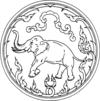
SealMap of Thailand highlighting Chiang Rai Province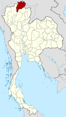
Country  Thailand
Capital Chiang Rai Government - Governor Sumet Saengnimnuan (since March 2009) Area - Total 11,678.4 km2 (4,509.1 sq mi) Area rank Ranked 12th Population (2000) - Total 1,129,701 - Rank Ranked 13th - Density 96.7/km2 (250.5/sq mi) - Density rank Ranked 46th Time zone Thailand Standard Time (UTC+7) ISO 3166 code TH-57 Chiang Rai (Thai: เชียงราย [tɕʰiaŋ˧raːj˧], Northern Thai: ᨩᩭᨦᩁᩣᩭ [tɕiaŋ˦˦haːj˦˦]) is the northernmost province (changwat) of Thailand. Neighbouring provinces are (from east clockwise) Phayao, Lampang and Chiang Mai. In the north it borders Shan State of Myanmar and Bokeo of Laos.
Geography
The average elevation of the province is 580 m. The north of the province belongs to the so-called Golden Triangle, at which the borders of Thailand, Laos and Myanmar converge - an area which was very unsafe because of the drug smuggling across the borders. The Mekong river forms the boundary with Laos, the Mae Sai and Ruak River to Myanmar. Through the town of Chiang Rai itself flows the Kok River.
While the eastern part of the province is relatively flat river plains, the western part consists of the mountainous terrain of the Hills of Northern Thailand.
While not the highest elevation of the province, the 1389 m high[1] Doi Tung (Flag hill) is the most important hill. The Wat Phra That Doi Tung temple on top of the hill according to the chronicles dates back to the year 911. Nearby is the Doi Tung royal villa, former residence of the Late Princess mother (mother of the present king) Somdej Phra Srinagarindra. Thanks to her activities the hills were reforested, and the hill tribes changed from growing poppy to other crops.
Climate
Climate data for Chiang Rai Month Jan Feb Mar Apr May Jun Jul Aug Sep Oct Nov Dec Year Average high °C (°F) 27.6
(81.7)30.9
(87.6)33.5
(92.3)34.9
(94.8)33.2
(91.8)31.7
(89.1)30.9
(87.6)30.6
(87.1)30.6
(87.1)29.8
(85.6)28.2
(82.8)26.5
(79.7)30.7 Daily mean °C (°F) 18.9
(66.0)21.1
(70.0)24.1
(75.4)26.8
(80.2)27.0
(80.6)26.8
(80.2)26.4
(79.5)26.1
(79.0)25.8
(78.4)24.5
(76.1)22.0
(71.6)18.8
(65.8)24.0 Average low °C (°F) 11.9
(53.4)12.9
(55.2)15.9
(60.6)19.7
(67.5)22.0
(71.6)22.9
(73.2)22.8
(73.0)22.6
(72.7)22.0
(71.6)20.3
(68.5)17.0
(62.6)12.8
(55.0)18.6 Precipitation mm (inches) 12.2
(0.48)7.8
(0.307)19.1
(0.752)89.8
(3.535)203.9
(8.028)211.2
(8.315)308.2
(12.134)385.4
(15.173)268.4
(10.567)142.4
(5.606)60.5
(2.382)24.6
(0.969)1,733.5
(68.248)Avg. rainy days 2 1 3 10 17 19 22 24 18 12 6 3 137 Source no. 1: Thai Meteorological Department[2] Source no. 2: Hong Kong Observatory [3] 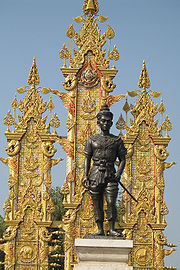 King Mengrai Monument at Chiang Rai Province
History
Populations have dwelled in Chiang Rai since the 7th century and it became the center of the Lanna Thai Kingdom during the 13th century. The region, rich in natural resources and textiles, was occupied by the Burmese until 1786.
Chiang Rai became a province in 1910, after being part of the kingdom of Lannathai for centuries. After Lannathai was incorporated into Thailand, it stayed an autonomous region and thus the Chiang Rai area was administered from Chiang Mai.
Chiang Rai province's Golden Triangle bordering Laos and Burma was once the hub of opium production which had much influence on cultural practices and lifestyles. Until this day, entire clans live together in bamboo houses and each village has its own individual character.
Demographics
The majority of the population are generally ethnic Thai, but 12.5% of the population belong to the hill tribes, a minority in the North of Thailand. A minority are of Chinese descent, mainly descendants of the Kuomintang soldiers who settled in the region, notably Santikhiri.
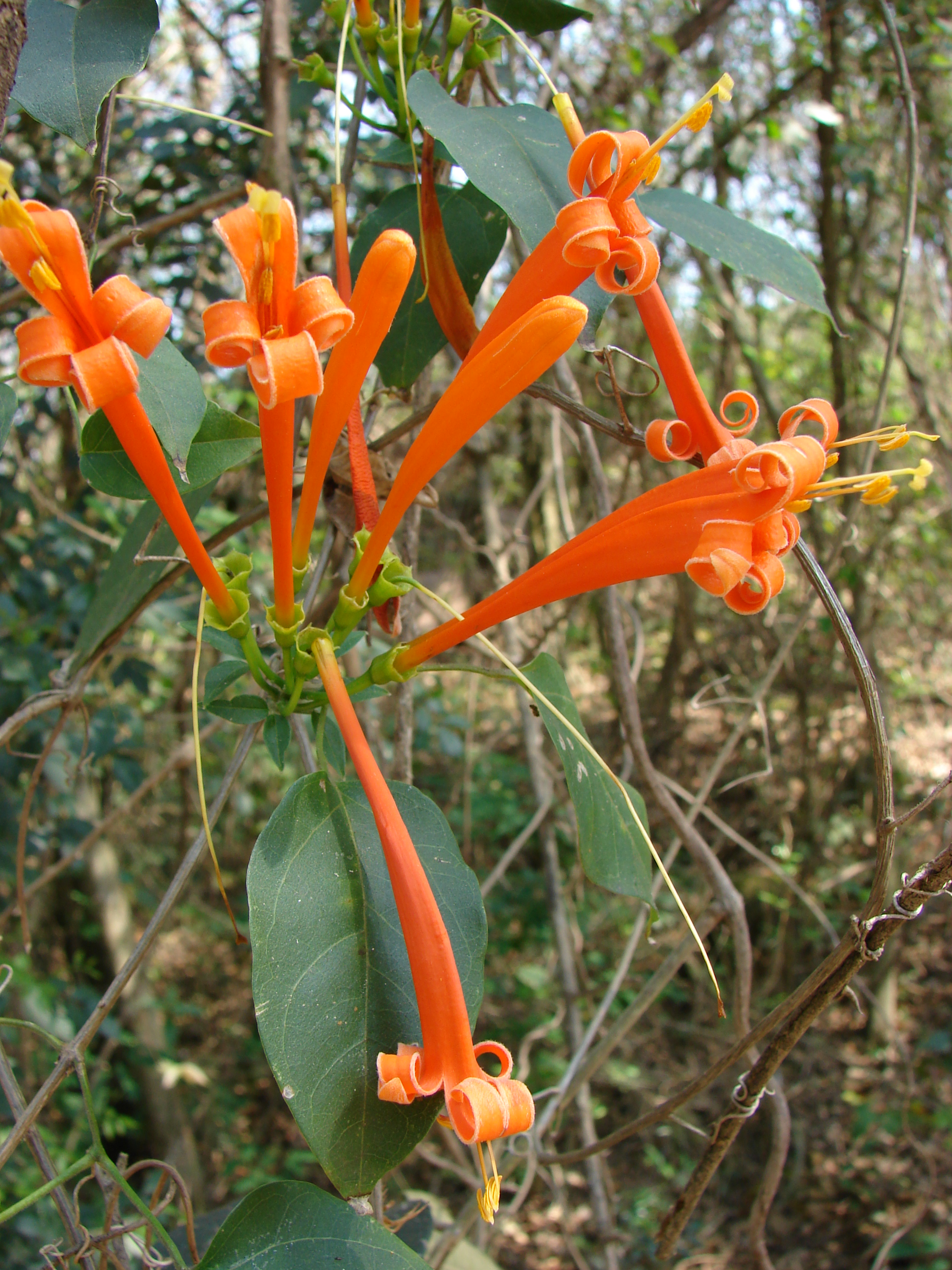
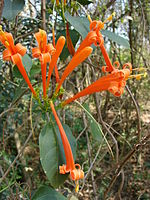 Orange trumpet
Symbols
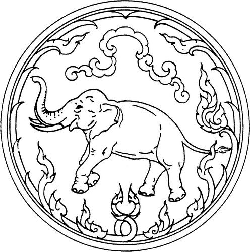
The seal of the province shows a white elephant, the royal symbol. It remembers that Chiang Rai was founded by King Mengrai, according to the legend because his elephant liked the place.
The provincial tree is the Tree Jasmine (Radermachera ignea), and the provincial flower is the Orange Trumpet (Pyrostegia venusta).
The former provincial slogan saids: "เหนือสุดในสยาม อร่ามดอยตุง ผดุงวัฒนธรรม รสล้ำข้าวสาร หอมหวานลิ้นจี่ สตรีโสภา ชาเลิศรส สัปปะรดนางแล"
Northernmost in Siam, beautiful Doi Tung, repository of culture, most delicious rice, sweet and fragrant litchi, beautiful women, the finest flavoured tea, pineapple from Nang-Lae (,source of the Giant Catfish).
While the current says "เหนือสุดในสยาม ชายแดนสามแผ่นดิน ถิ่นวัฒนธรรมล้านนา ล้ำค่าพระธาตุดอยตุง"
The northernmost of Siam, the frontiere of three lands, the home to the culture of Lanna and Doi Tung Temple
Administrative divisions
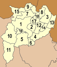
The province is subdivided in 18 districts (amphoe). These are further subdivided into 124 subdistricts (tambon) and 1510 villages (muban).
Transportation
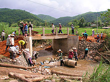 Construction of a reinforced concrete bridge in Chiang Rai Province (2009).
Chiang Rai province is intersected by Asian Highway 2, which runs over 13.000 km (over 8000 miles) from Denpasar in Indonesia to Kosravi in Iran, and by Asian Highway 3, which runs for over 7,000 km (4,300 mi) from Kentung in Myanmar to Ulan-Ude in Russia.
Rail
There is no railway system in Chiang Rai.Bus service
Decent bus services are available in the province but in more remote areas, songthaews (public passenger pick-up vehicles) are the norm.Air
Chiang Rai International Airport at the moment only sees domestic flights.Tourism
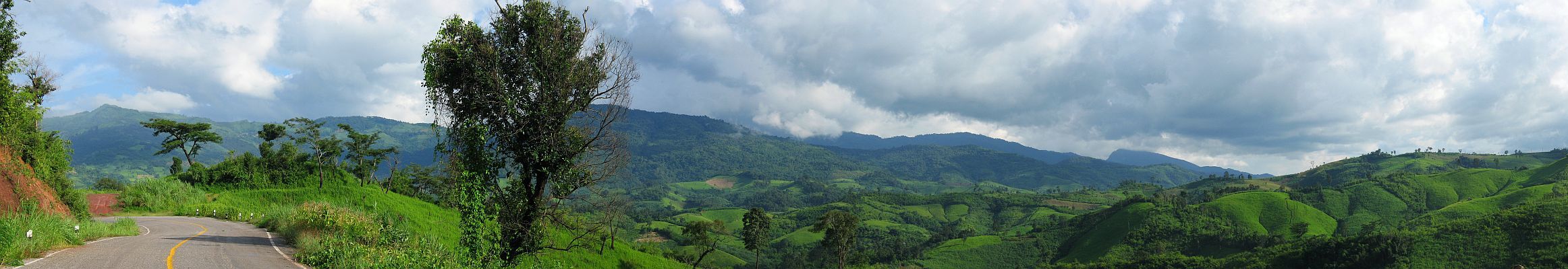
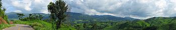 Panoramic view of the Phu Chi Fa mountain range
The province is rich in tourism resources in terms of natural attractions and antiquities, evidence of its past civilisation. It is also home to various hilltribes who follow fascinating ways of life. Chiang Rai is also a tourism gateway into Myanmar and Laos.
Attractions
Mae Fah Luang Art and Cultural Park (Rai Mae Fah Luang) is located at Pa Ngiw Village, about 5 kilometers from the city center. It was founded by the late Princess Mother, who bought a 140 rai plot to set up a center for developing the youths from rural areas under the supervision of the Mae Fah Luang Foundation. The garden is a park cum museum preserving Lanna cultural objects.
Doi Tung (ดอยตุง) is a revered mountain which includes the Doi Tung Palace and the Mae Fa Luang Flower Garden. The Wat Phra That Doi Tung Holy Relic, an old religious site on top of the mountain, is about 2,000 metres above sea level.
Wat Rong Khun (วัดร่องขุ่น): This temple was designed and built by artist Chaloemchai Khositphiphat. A white ordination hall – Phra Ubosot - is decorated with silver glittering pieces of mirrors. There are large mural paintings of the Lord Buddha in different gestures.
The Golden Triangle (สามเหลี่ยมทองคำ), locally called "Sop Ruak", is where the Mekhong meets the Ruak River and also where the borders of three countries, Laos, Burma and Thailand, meet together. There are remains of many ancient places and structures attesting to the area having been settled by people in the past.
Doi Mae Salong (ดอยแม่สลอง) is home to a community settled by remnants of the 93rd Division of the Republic of China Army, who moved out of Yunnan province, China, in to Burma and after to Thai territory at the end of the Chinese Civil War in 1949. Today the town is a tourist attraction renowned for its tea and its small-town ambience on high hills.
Wat Phra Kaeo (วัดพระแก้ว) once housed Thailand's most revered Buddha image, the Emerald Buddha. It was discovered in 1444. The statue had been moved by various state rulers to be placed in their respective capitals as a symbol of dominance, including Lampang, Chiang Rai and Vientiane before finally enshrined in Bangkok's Wat Phra Kaeo during the reign of King Rama I of the Rattanakosin period.
Kok River (แม่น้ำกก) flows through the town of Chiang Rai and is 130 kilometres long. Long-tailed boats and cruises can be made from town to travel. Hilltribe villages in the area are popular with travelers.
Amphoe Mae Sai: Mae Sai (แม่สาย), borders on Burma's Tachileik (ท่าขี้เหล็ก) marked by the Mae Sai River with a bridge spanning both sides. The area has a market selling lots of different goods.
Doi Nang Non (ดอยนางนอน), "sleeping woman mountain", is unusual land feature located in Mae Chan district on the western side of the highway between Chiang Rai and Mae Sai.[4] The silhouette of the mountain range takes the shape of a reclining woman when seen from certain angles. There is a viewpoint at Mae Chan, from where this land feature can be observed best.[5]
The Hall of Opium, Golden Triangle Park (หอฝิ่นอุทยานสามเหลี่ยมทองคำ) exhibits the history of opium in the Golden Triangle, its origin, opium war when people lived on opium planting and smoking, as well as the recovery of the people who lived here.
Chiang Saen (เชียงแสน): an ancient town which once served as the main town before King Mengrai established Chiang Rai as the capital of the Lanna Kingdom in 1262. Traces of old double city walls and many other antiquities still remain in and outside the district town. The attractions include Chiang Saen National Museum (พิพิธภัณฑสถานแห่งชาติเชียงแสน), Wat Phra That Chedi Luang (วัดพระธาตุเจดีย์หลวง) and Wat Pa Sak (วัดป่าสัก). Phu Chi Fa (ภูชี้ฟ้า): There is a trail which leads from a parking lot up to the viewing point on the top of this mountain, a distance of 1.8 kilometres. From the sheer cliff of Phu Chi Fa, views, especially the sea of clouds at sunrise, can be seen. The cool climate produces flowering shrubs of various species.
Leisure Activities
Golf Santiburi Chiang Rai is one of the best courses in the country and is only 15 minutes from the city. Waterford is an attractive course about 45 minutes north of Chiang Rai city. The Military course is on the way to the Mae Fah Luang Bridge, not far from the Dusit Hotel. The old airport has a 9 hole course.
Long Tail Boat Ride A long tail boat ride on the Kok River is a fun way to experience the scenery and see hill tribe villages. There are daily trips from Thaton, near the Burmese border to Chiang Rai. The main boat station is on the north side of the Mae Fah Luang Bridge, not far from the Rimkok Hotel.
Elephant Riding Elephant riding is possible at Baan Ruamit, about 30 minutes from Chiang Rai by car or 1 hour by long tail boat ride.
Disc Golf Also known as 'Frisbee Golf' - there is a 9 hole course 2km NW of Chiang Rai town, in a lovely park with rock formations and tall shade trees.
Adventure
Trekking An extensive network of trails mainly used by hill tribe villagers covers the mountain areas of Mae Suai, Mae Salong, Doi Chaang and the banks along the Mae Kok River.
Rock Climbing Limestone karst hills are peppered throughout the province, some have straight-up sides - potentially great for climbing, though often vine covered. There are several locations around Chiang Rai which have been cleared, also containing ziplines.
Mountain Biking Chiang Rai has incredible mountain biking because of the extensive network of paved roads with little traffic and dirt roads in the mountains. A nice day ride is to start in the city, go out to the elephant village and continue on past it until you find a small single track suspension bridge. Cross it and turn left, back towards Chiang Rai. On the way you will pass two hot springs and eventually end up back in the city.
Caving 1 Km up the Mae Kok river, west of Chiang Rai town, is 'Crouching Lion Hill.' It parallels the Mae Kok river and has a Buddha cave on its west end, and an easy-access cave near its east end. The eastern cave is actually a 3-chambered cave, each with a natural skylight at its apex, the largest chamber is as big as a giant sequoia tree. Trekkers can use it to walk through the entire hill.
Local Products
Chiang Rai is rich in handicraft items such as hand-woven cotton materials, dresses and hilltribe silver ornaments, as well as wood-carving products. Certain food items are quite popular such as Naem and Mu Yo (preserved and fermented pork sausages). Agricultural products include lychee (April–May), pineapples, tea, and other products from the royal projects.
Nightlife
The provincial town (amphoe muang) has a few live music pubs and discothèques. Aimed at foreign tourists, there is traditional music and performances in the Night Bazaar. There are also plenty of beer bars, some with hostesses, around town.
Local Culture
The north of Thailand's culture is Lanna in origin and the people are very proud of their northern roots. The region is home to distinctly different food, music, arts, way of life and even language. Chiang Rai is also a melting pot of hill tribes and their own unique cultures.
Lifestyle
Khon Muang are the city folk who originally came from Chiang Mai, Lamphun, Lampang and Phrae. Culturally, they design their houses having only one floor with wooden gable-decorations called Ka-Lae. They are known for their craftsmanship in wood carving, weaving, lacquerware and musical instruments.
Tai Yai, Burmese in origin, harvest rice, farm, raise cattle and trade. Their craftsmanship lies in weaving, pottery, wood carving and bronzeware.
Akha have the largest population of any hill tribe in the region. Originating from Tibet and Southern China, they dwell on high grounds around 1,200 meters above sea-level. Within their villages they build a Spirit Gateway to protect them from evil spirits.
Lahu are also from the Yunnese area and live in high areas. They are known as hunters and planters. Karen live in various areas of the region which have valleys and riverbanks.
Chin Hor, these are the former Kuomintang who took refuge in the area, mainly Doi Mae Salong Hmong from southern China are located on high land. They raise livestock and grow rice, corn, tobacco and cabbage. They are also known for their embroidery and silver.
Tai Lue live in dwellings of usually only a single room wooden house built on high poles. They are skilled in weaving.
Lisaw from southern China and Tibet are renowned for their colorful dress and also build their dwellings on high poles. They harvest rice and corn and their men are skilled in hunting.
Yao reside along mountain sides and grow corn and other crops. They are skilled blacksmiths, silversmiths and embroiders.
Events & Festivals
Wai Sa Phaya Mengrai or Phokhun Mengrai Maharat Festival (งานไหว้สาพญาเม็งราย หรือ งานพ่อขุนเม็งรายมหาราช) is held from January 23 – February 1. The Buang Suang worshipping ceremony is to commemorate Phokhun Mengrai Maharat.
Dok Siao Ban or Blooming Siao Flower Festival at Phu Chi Fa (งานดอกเสี้ยวบานที่ภูชี้ฟ้า) is held during 13–15 February. There are sports competitions and cultural performances from hilltribes at Ban Rom Fa Thai in Amphoe Thoeng.
Songkran Festival and Boat Races of Mueang Chiang Saen (งานประเพณีสงกรานต์และแข่งเรือเมืองเชียงแสน) is held during 13–18 April of each year. In this festival, there is a parade, water bathing ceremony of the Phrachao Lanthong Buddha image, boat races and folk performances.
Lichi Fair (งานเทศกาลลิ้นจี่และของดีเมืองเชียงราย) is held around the middle of May every year. There is a float competition, Lichi beauty contest and booths of many products at the provincial stadium of Chiang Rai.
Buatong Ban or Blooming Mexican Sunflower Festival (งานเทศกาลดอกบัวตองบาน) is held in November, affording people the opportunity to see the sunflower fields, waterfalls and mist at Ban Hua Mae Kham, Amphoe Mae Fa Luang. There are also hilltribe performances.
Chiang Rai Flower Festival (งานเทศกาลเชียงรายดอกไม้บาน) is held during the end of December to January every year. There are flower processions, flower gardens, Miss Thinn Thai Ngarm Contest and also the fair of agricultural products and the variety of flowers.
Chiang Saen, Mae Chan, and Doi Mae Salong are three substantially different places. Chiang Saen's culture has been influenced by its collection of Buddhist scriptures and temples. It was once the provincial capital. Mae Chan's name lies in its silver and tribal handicrafts. Once officially unrecognized by the Thai government, Doi Mae Salong is a Chinese KMT (Kuomintang) area renowned for its natural beauty and unique Yunnanese culture. Besides the Chinese 93rd Infantry of the Kuomintang, several other ethnic minorities have settled down in the region including the Tai Yai, Tai Lue, Tai Khoen and Tai Yuan.
Art
- The area is known for its traditional Lanna music with instruments such as the sau (fiddle) and kaen (panpipe).
- The north of Thailand has its own distinctive art and crafts including bronze casting, carving, mulberry paper, Buddha Images and sign painting.
- Local handmade items popular with tourists are clay charcoal stoves, tea sets, brooms and dust-pans, and umbrellas for shade and decoration.
- Some of the craftswork is made ofr spiritual purposes.
Local Food
The staple diet of local people consists of sticky rice (glutinous rice) which is rolled into balls and served in small hand-made bamboo containers. Typical dishes in the area are khan khanoon (spicy jackfruit curry), khaeng yuak (banana palm leaves), sai oo-a (pork sausages) and Yunnese and Burmese rice noodles.
Medical Health Care
The popular Chiang Rai hospitals are:
- Chiang Rai Regional Hospital
- Kasemrad Sriburin General Hospital
- Overbrooke Hospital
Retirement
Many foreign retirees make Chiang Rai their home due to the low cost of living and the agreeable climate.
References
- ^ Geographical data
- ^ "30 year Average (1961-1990) - CHIANG RAI". Thai Meteorological Department. http://www.tmd.go.th/EN/province_stat.php?StationNumber=48303. Retrieved 2010-04-20.
- ^ "Climatological Normals of Chiang Rai". Hong Kong Observatory. http://www.hko.gov.hk/wxinfo/climat/world/eng/asia/se_asia/chiang_rai_e.htm. Retrieved 2011-11-13.
- ^ Doi Nang Non Location
- ^ Doi Nang Non View Point
External links
- Website of province (Thai)
- Province page from the Tourist Authority of Thailand
- Volunteer to help the Hill Tribe villagers of Chiang Rai
- The Switzerland of Thailand - Doi Tung

Shan State,  Myanmar
Bokeo Province,  Laos
Laos
 Chiang Rai Province

Chiang Mai Province Lampang Province Phayao Province Chiang Rai Main article Chiang Rai ProvinceCapital city Districts (amphoe) Mueang Chiang Rai · Chiang Khong · Chiang Saen · Doi Luang · Khun Tan · Mae Chan · Mae Fa Luang · Mae Lao · Mae Sai · Mae Suai · Pa Daet · Phan · Phaya Mengrai · Thoeng · Wiang Chai · Wiang Chiang Rung · Wiang Kaen · Wiang Pa Pao ·
Related topics Provinces of Thailand Capital: Bangkok North North-East Amnat Charoen · Bueng Kan · Buri Ram · Chaiyaphum · Kalasin · Khon Kaen · Loei · Maha Sarakham · Mukdahan · Nakhon Phanom · Nakhon Ratchasima · Nong Bua Lamphu · Nong Khai · Roi Et · Sakon Nakhon · Sisaket · Surin · Ubon Ratchathani · Udon Thani · YasothonCentral Ang Thong · Chai Nat · Kamphaeng Phet · Lop Buri · Nakhon Nayok · Nakhon Pathom · Nakhon Sawan · Nonthaburi · Pathum Thani · Phetchabun · Phichit · Phitsanulok · Phra Nakhon Si Ayutthaya · Samut Prakan · Samut Sakhon · Samut Songkhram · Saraburi · Sing Buri · Sukhothai · Suphan Buri · Uthai ThaniEast West South Chumphon · Krabi · Nakhon Si Thammarat · Narathiwat · Pattani · Phang Nga · Phatthalung · Phuket · Ranong · Satun · Songkhla · Surat Thani · Trang · YalaCoordinates: 19°54′49″N 99°49′37″E / 19.91361°N 99.82694°E
Categories:- Chiang Rai Province
- Provinces of Thailand
- Populated places on the Mekong River


Wikimedia Foundation. 2010.