- Chachoengsao Province
-
Chachoengsao
ฉะเชิงเทรา— Province — 
SealNickname(s): Paet Rio Map of Thailand highlighting Chachoengsao Province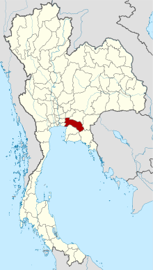
Country  Thailand
Capital Chachoengsao town Government – Governor Suraphon Phongthatsirikun (since May 2009) Area – Total 5,351.0 km2 (2,066 sq mi) Area rank Ranked 41st Population (2000) – Total 635,153 – Rank Ranked 37th – Density 118.7/km2 (307.4/sq mi) – Density rank Ranked 39th Time zone Thailand Standard Time (UTC+7) ISO 3166 code TH-24 Chachoengsao (Thai ฉะเชิงเทรา (Pronunciation), Thai pronunciation: [tɕàʔ tɕɤːŋ saw]) is a province (changwat) of Thailand. Neighboring provinces are (from north clockwise) Prachin Buri, Sa Kaeo, Chanthaburi, Chon Buri, Samut Prakan, Bangkok, Pathum Thani and Nakhon Nayok. It also has a short coast to the Gulf of Thailand.
Contents
History
Chachoengsao or Paet Rio is a province in the Central region. It has an old history back to the reign of King Borommatrailokkanat in the Ayutthaya period. Most of the people have settled by the Bang Pakong River and along canals. “Luangpho Phuttha Sothon” is a centre of faith of the people of Paet Rio. In the past, Chachoengsao was a fourth class city under the Ministry of Defence. During the reign of King Rama I, it was attached to the Ministry of Interior. Until the reign of King Rama V who changed the administration system, Chachoengsao became a city in the Prachin Buri Circle. In 1916, its status was changed from a city to a province. “Chacheongsao” is a Khmer word which means a deep canal. The name “Paet Rio” comes from the story that the city once teemed with giant snake-head fish; up to 8 cuts were required on the sides in making sun-dried fish.
Geography
The west part of the province is the low river plain of the Bang Pa Kong River, which is used extensively for farming rice. To the east is more hilly terrain, with an average height of more than 100 m above sea level.
Symbols
The provincial seal shows the main hall of the Sothornvararamvoraviharn temple. In this hall is the most important Buddha image of the province, called Luang Por Buddha Sothorn.
Provincial tree is Peltophorum dasyrachis. The tree was assigned to the province by Queen Sirikit on the 50th anniversary of the coronation of King Rama IX in 2000. Provincial flower is the Yellow Flamboyant (Peltophorum pterocarpum).
The provincial slogan is The Bountiful Bang Pakong River,the Sacred Buddha Image of Luangpho Sothon, Phraya Si Sunthon the Scholar of Thai Language, and the Pristine Ang Rue Nai Forest
Climate and weather
Climate data for Bangkok (1961-1990) Month Jan Feb Mar Apr May Jun Jul Aug Sep Oct Nov Dec Year Average high °C (°F) 32.0
(89.6)32.7
(90.9)33.7
(92.7)34.9
(94.8)34.0
(93.2)33.1
(91.6)32.7
(90.9)32.5
(90.5)32.3
(90.1)32.0
(89.6)31.6
(88.9)31.3
(88.3)32.7 Daily mean °C (°F) 25.9
(78.6)27.4
(81.3)28.7
(83.7)29.7
(85.5)29.2
(84.6)28.7
(83.7)28.3
(82.9)28.1
(82.6)27.8
(82.0)27.6
(81.7)26.9
(80.4)25.6
(78.1)27.8 Average low °C (°F) 21.0
(69.8)23.3
(73.9)24.9
(76.8)26.1
(79.0)25.6
(78.1)25.4
(77.7)25.0
(77.0)24.9
(76.8)24.6
(76.3)24.3
(75.7)23.1
(73.6)20.8
(69.4)24.1 Rainfall mm (inches) 9.1
(0.358)29.9
(1.177)28.6
(1.126)64.7
(2.547)220.4
(8.677)149.3
(5.878)154.5
(6.083)196.7
(7.744)344.2
(13.551)241.6
(9.512)48.1
(1.894)9.7
(0.382)1,496.8
(58.929)Avg. rainy days (≥ 1 mm) 1 3 3 6 16 16 18 20 21 17 6 1 128 Sunshine hours 272.8 251.4 269.7 258.0 217.0 177.0 170.5 161.2 156.0 198.4 234.0 263.5 2,629.5 Source no. 1: Thai Meteorological Department[1] Source no. 2: Hong Kong Observatory [2] Administrative divisions
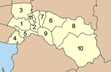
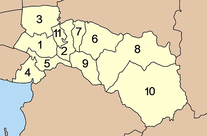
The provinces is subdivided into 11 districts (amphoe). These are further subdivided into 93 subdistricts (tambon) and 859 villages (muban).
Tourism
Interesting Places
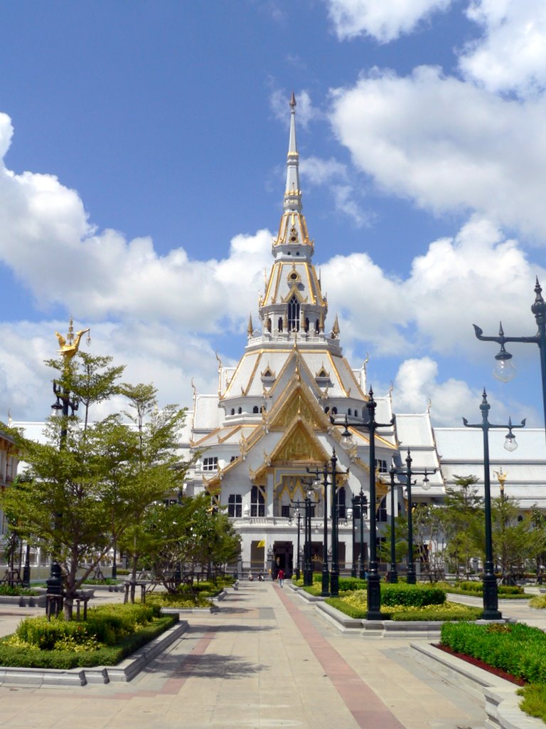
 Wat Sothornwararamworaviharn
Phraya Sri Sunthorn Voharn Monument (Noi Ajarnrayangoon) The philosopher of Thai language. He is the nobleman of King Rama V. He wrote a large number of Thai literature.
Wat Sothon Wararam Woraviharn or Wat Hong is the oldest temple in Chachoengsao. It was built in the reign of the late Krung Sri Ayudhaya time. There is the famous Buddha in this temple, "Luang Por Sothorn". This Buddha is the symbol of Chachoengsao, and is revered by local residents.
Chachoengsao Fortifications. It was located at Marupong road. It was constructed in King Rama III time. There are many cannons on its wall. These fortifications used to be the Siamese base for fighting against the Angyee rebel.
Chao Mae Guan Im Loy Nam. This Goddess Guan Im (Guan Yin) figure was created from ceramic. It was located at Suppakij road. It was found in 1997 around Bangpakong bridge.
Khao Hin Sorn. It is the small hill. Its attractiveness is the curious stone formation, which are located as though someone had set them up.
Phraya Sisunthonwohan (Noi Acharayangkun) Monument Phraya Sisunthonwohan (Noi Acharayangkun) was a native of Paet Rio. He was the author of many textbooks on Thai language for teaching purposes, such as Munlabot Banphakit, Wahanit Nikon, Akson Prayok, Sangyok Phithan, Waiphot Phichan, Phisan Karan, etc.; these can be considered the most complete textbooks for Thai youth at that time.
Chachoengsao City Fortress (ป้อมเมืองฉะเชิงเทรา) was made to protect an enemy invasion. In the reign of King Rama V, it was a stronghold for an army to suppress the Ang Yi rebellion of illegal Chinese opium traders who instigated chaos and robbed the people.
City Pillar Shrine (ศาลหลักเมือง) The building of Thai architecture has a four-porched roof with a Prang finial. Inside, two city pillars are housed. The old one was built in 1834 during the reign of King Rama III. The other belongs to the present day; it was constructed in 1895 during the reign of King Rama V.
Suan Somdet Phra Srinagarindra Park Chachoengsao (สวนสมเด็จพระศรีนครินทร์ฉะเชิงเทรา) The park is dedicated to the memory of the mother of the King of Thailand. It is located in front of the provincial hall, near the town centre. There is a large lagoon at its centre surrounded by a walking path and shady trees. It is a popular recreation facility for local residents.
Wat Mueang or Wat Pitulathirat Rangsarit (วัดเมืองหรือวัดปิตุลาธิราชรังสฤษฎิ์) Initially, the temple was called ‘Wat Mueang.’ In 1908, King Rama V on his royal visit to Chachoengsao renamed the temple ‘Wat Pitulathirat Rangsarit,’ which means the temple built by the king’s uncle.
Kuan Im Loi Nam The Seneca ceramic tile statue in the round of Kuan Im or Kuan Yin (Goddess of Mercy) is around 119 cm high and weighs 40 kg. This yellowish solid figure holds a scripture. Therefore, this is considered Kuan Yin in the posture of holding a scripture to preach humanity of all classes and castes.
Wat Uphai Phatikaram or Wat Sam Po Kong (วัดอุภัยภาติการามหรือวัดซำปอกง) On the temple grounds, a Chinese style pavilion houses Luangpho To (Phra Trairattana Nayok) or called by the Chinese people as ‘Chaopho Sam Po Kong.’ Only three Buddha images in this form are found in Thailand.
Talat Ban Mai or Talat Rim Nam Roi Pi (ตลาดบ้านใหม่หรือตลาดริมน้ำร้อยปี) It is a traditional market by the Bang Pakong River aged more than 100 years. This riverside community has reflected the villagers’ way of life since before the reign of King Rama V.
Wat Chin Pracha Samoson (Wat Leng Hok Yi) It is a Chinese temple in Mahayana Buddhism, which extends from Wat Leng Noei Yi in Bangkok. There are three principal Buddha images and eighteen of the Perfected One, which were made from paper and brought in from China.
Wat Phayakkha Intharam or Wat Chedi (วัดพยัคฆอินทารามหรือวัดเจดีย์) A silver inscription found in the crack at the neck of the bell body of the giant pagoda on the temple ground made it known that the temple had been built during the reign of King Rama V, by Nai Suea or Phra Kriangkraikrabuanyut, who was chief of the city of Chachoengsao, and his wife named In.
Wat Sampathuan Nok The most interesting item is the Ubosot (ordination hall) with the stucco design on the eaves of its balcony, which was built when Phra Phutthirangsimuniwong (Ho Phromchoto) was the abbot. The Bang Pakong Dam can be seen in the distance from the temple’s pier.
Bang Pakong Dam (เขื่อนทดน้ำบางปะกง) The dam serves as a wall to protect the area from saline water, and a source of water for consumption, and allocation to support an expansion of the industrial sector in the East.
Talat Khlong Suan Roi Pi (100-year-old Garden-Canal Market) From the past to the present, the people here, a combination of Thai Chinese, Buddhist, and Muslim people, live their happy life harmoniously. The market is the ideal to show the old ways of life of more than 100 years ago.
The Shrine and Monument of King Taksin the Great (ศาลและอนุสาวรีย์สมเด็จพระเจ้าตากสินมหาราช) were built as a memorial to the king who won a victory in a fight with the Burmese troops at the mouth of the Cholo River.
Wat Pho Bang The reclining Buddha image is enshrined in the hall. Within the temple compound, many Khangkhao Mae Kai (flying foxes) are seen on trees. This is the world’s largest species of bats. From an observation, the bats here fly to feed along the Thai border or on the Cambodian side.
Wat Chaeng (วัดแจ้ง) The beautiful Ubosot (ordination hall) is a combination of Sino – Thai arts, with sculptures of an ogre on its sides. It is unknown when it was built. It was long told that on the way to beat the Khmer, King Rama I led his troops to arrive at this place at dawn, so a temple was built and named ‘Wat Chaeng,’ literally meaning ‘temple of dawn.’
King Taksin the Great Stupa Memorial (อนุสรณ์สถานพระสถูปเจดีย์สมเด็จพระเจ้าตากสินมหาราช) A pagoda was constructed by the king to commemorate his victory. Later, the area was eroded by currents before the pagoda collapsed around 1948. Then, the stupa memorial was built on the same area.
Muban Namtan Sot (หมู่บ้านน้ำตาลสด) This palm sap village is the sole production source of ready-to-drink palm sap in the East. See the procedures of making palm sap from a palm tree. Witness the lifestyle of farmers who make palm sap.
Mango Orchards (สวนมะม่วง) Chachoengsao The mango trees are mostly found in Amphoe Bang Khla and Amphoe Plaeng Yao. Popular varieties being grown by mango orchardists are Raet, Khiao Sawoei, Nam Dok Mai, Chaokhun Thip, Thong Dam, etc. The mango season begins in March.
Khao Hin Son Royal Development Study Centre The area can be considered a living natural museum and a comprehensive development centre. It can also serve as a model and set an example of development for other areas, with cooperation from government agencies and the private sector.
Khao Hin Son (เขาหินซ้อน) is a fairly high mountain consisting of small and large rocks in different shapes scattered by nature. Around Khao Hin Son is ‘Saun Rukkhachat Somdet Phra Pinklao,’ or the arboretum where the shrine of Somdet Phra Pinklao is located.
Wanakaset or Village Society Development Study Centre or Ban Santitham (วนเกษตรหรือศูนย์ศึกษาพัฒนาการสังคมหมู่บ้านหรือบ้านศานติธรรม) More than 700 - 800 species of plants are grown as herbs for medical treatment. Inside, there is a wooden Thai–styled house on stilts with rhombus-shaped roof tiles.
Wat Phrathat Wayo (Wat Huai Nam Sap) Inside, there are many Buddha images and oil paintings depicting the Lord Buddha’s life. In addition, in the temple compound lays the monument of Than Pho Khun, monument of Somdet Pho Saen Kham Fa, and Wihan (hall) of the reclining Buddha image.
Krabok Khu Wildlife Breeding Station (สถานีเพาะเลี้ยงสัตว์ป่ากระบกคู่) The station conducts research, breeding, and propagating of rare and endangered species.
Khlong Siyat Reservoir (อ่างเก็บน้ำคลองสียัด) The reservoir’s entrance is opposite the Khlong Takrao Sub-district Administration Organisation.
Khao Ang Rue Nai Wildlife Sanctuary is a conservation zone covering an area of 643,750 rai in the heart of a vast forest land. This is the last abundant piece of forest land of the East, and there is plenty of biodiversity. Also, it is the source of the Bang Pakong River in Chachoengsao, the Tanot Canal in Chanthaburi, and the Prasae River in Rayong.
Local Products
Agricultural Produce including mango of different varieties, jasmine rice, eggs, fresh shrimp, and aromatic coconut, are available for sale in general in Chachoengsao.
Desserts are Krayasat (sticky and sweet rice), Khanom Pia (Chinese pastry), and Khanom Chak (cononut meat, flour, and sugar mixed and grilled).Culture
Festivals
Luangpho Sothon Worship Fair is held three times a year in the lunar calendar:
- Chinese New Year Festival is held by the Chinese Association together with merchants, civil servants, and the people of Chachoengsao, from the first day to the fifth day of the waxing moon in the Chinese first lunar month, totalling five days and nights.
- Mid-Fifth Month Festival starts from the full moon day to the second day of the waning moon, totalling three days and nights. It is held to mark the movement of Luangpho Sothon from the river to be enshrined at the temple.
- Mid-Twelfth Month Festival starts from the twelfth day of the waxing moon to the first day of the waning moon. Back in 1890, there was an outbreak of smallpox. The villagers at the time asked for recovery from illness with Luangpho Sothon, and held a ceremony to celebrate the Buddha image. The celebration has become a tradition. Presently, Chachoengsao Province and Wat Sothon jointly hold the Luangpho Sothon Worship Fair and the Chachoengsao Red Cross Fair every year. The celebrations and the procession of the replica of Luangpho Sothon by land and by river are the great annual event of the province.
Paet Rio Mango and Products Fair is held around March to April of every year at Phutthasothon School in Amphoe Mueang Chachoengsao, when mango trees bear fruit. There are booths of mango and agricultural produce on sale, agricultural produce contests, and agricultural exhibitions.
Chachoengsao Red Cross Fair coincides with the Luangpho Sothon Worship Fair in November of every year at the Suan Somdet Phra Srinagarindra Park Chachoengsao.References
- ^ "30 year Average (1961-1990) - BANGKOK METROPOLIS". Thai Meteorological Department. http://www.tmd.go.th/EN/province_stat.php?StationNumber=48455. Retrieved 2010-04-19.
- ^ "Climatological Normals of Bangkok". Hong Kong Observatory. http://www.hko.gov.hk/wxinfo/climat/world/eng/asia/se_asia/bangkok_e.htm. Retrieved 2010-06-24.
External links

Nakhon Nayok Province Prachin Buri Province Bangkok
Samut Prakan Province
Sa Kaew Province  Chachoengsao Province

Bight of Bangkok Chonburi Province Chanthaburi Province Provinces of Thailand Capital: BangkokNorth North-East Amnat Charoen · Bueng Kan · Buri Ram · Chaiyaphum · Kalasin · Khon Kaen · Loei · Maha Sarakham · Mukdahan · Nakhon Phanom · Nakhon Ratchasima · Nong Bua Lamphu · Nong Khai · Roi Et · Sakon Nakhon · Sisaket · Surin · Ubon Ratchathani · Udon Thani · YasothonCentral Ang Thong · Chai Nat · Kamphaeng Phet · Lop Buri · Nakhon Nayok · Nakhon Pathom · Nakhon Sawan · Nonthaburi · Pathum Thani · Phetchabun · Phichit · Phitsanulok · Phra Nakhon Si Ayutthaya · Samut Prakan · Samut Sakhon · Samut Songkhram · Saraburi · Sing Buri · Sukhothai · Suphan Buri · Uthai ThaniEast West South Chumphon · Krabi · Nakhon Si Thammarat · Narathiwat · Pattani · Phang Nga · Phatthalung · Phuket · Ranong · Satun · Songkhla · Surat Thani · Trang · YalaCoordinates: 13°41′15″N 101°04′13″E / 13.6875°N 101.07028°E
Categories:


Wikimedia Foundation. 2010.