- Nan Province
-
Nan
น่าน— Province — 
SealMap of Thailand highlighting Nan Province
Country  Thailand
Capital Nan city Government – Governor Seni Chittakasem (since October 2010) Area – Total 11,472.1 km2 (4,429.4 sq mi) Area rank Ranked 13th Population (2009) – Total 475,614 – Rank Ranked 55th – Density 41.5/km2 (107.4/sq mi) – Density rank Ranked 73rd Time zone Thailand Standard Time (UTC+7) ISO 3166 code TH-55 Website http://www.nan.go.th Nan (Thai: น่าน) is one of the northern provinces (changwat) of Thailand. Neighboring provinces are (from south clockwise) Uttaradit, Phrae and Phayao. To the north and east it borders Sainyabuli of Laos.
Contents
Geography
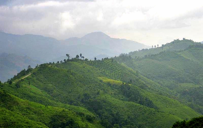
The province is located in the remote valley of the Nan River, surrounded by mountains covered with forests. The highest mountain is the 2079 meter high Doi Phu Kha in Amphoe Pua, north-east of the city of Nan towards the border with Laos.
Climate data for Nan (1961-1990) Month Jan Feb Mar Apr May Jun Jul Aug Sep Oct Nov Dec Year Average high °C (°F) 30
(86)33
(91)35
(95)37
(99)35
(95)33
(91)32
(90)32
(90)32
(90)32
(90)31
(88)29
(84)33
(90.6)Average low °C (°F) 13
(55)15
(59)18
(64)22
(72)24
(75)24
(75)24
(75)24
(75)23
(73)22
(72)19
(66)14
(57)20.2
(68.3)Precipitation mm (inches) 8
(0.31)14
(0.55)28
(1.1)103
(4.06)175
(6.89)156
(6.14)207
(8.15)248
(9.76)205
(8.07)95
(3.74)19
(0.75)6
(0.24)1,264
(49.76)[citation needed] History
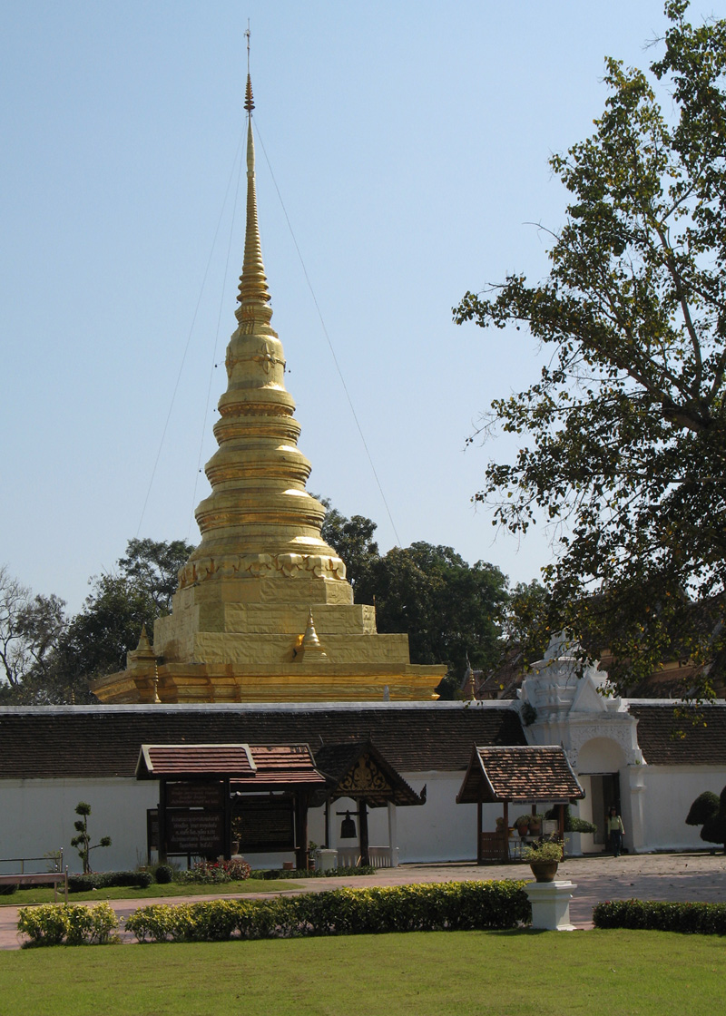
 Phra That Chae Haeng, Nan Province
For centuries Nan was an independent kingdom but, due to its remoteness, had few connections to the other kingdoms. The first kingdom around the city Mueang Pua (also known as Varanagara) was created in the late 13th century. Its rulers, the Phukha dynasty, were related to the founders of Vientiane, however it became associated with the Sukhothai kingdom as it was easier to reach from the south than from the east or west. In the 14th century the capital was moved to its present location at Nan.
In the 15th century, when Sukhothai declined in power, it became vassal of the kingdom of Lannathai. In 1443 King Kaen Thao of Nan plotted to capture neighboring Phayao by asking King Tilokaraj to help him fight against Vietnamese troops attacking Nan, even though there was no such threat. Kaen Thao killed the king of Phayao, however the troops of Tilokaraj then attacked Nan itself, and captured it in 1449.
When Lannathai was under Burmese rulership, Nan tried to liberate itself many times without success, which finally led to direct Burmese rulership of Nan in 1714. In 1788 the Burmese rulers were finally driven back, however Nan had to then accept the new Siam rulers. In 1893 after the Paknam crisis Siam had to give a big part of eastern Nan to French Indochina.
However Nan kept some degree of independence from the Siamese rulers, and it took until 1931 to become fully integrated into Thailand, and the province was then created.
Before the early 1980s bandits as well as People's Liberation Army of Thailand (PLAT) guerillas were a big problem in the province, usually destroying highway construction overnight. With the help of the army and the more stable political system the province improved significantly, but is still a very rural and remote area.
For further information, see the article on Nan, Thailand
Demographics
10.5% of the population belong to the hill tribes.
Certain inhabitants known as the T'in or Mal people speak a Northern Mon-Khmer or Khmuic language, T'in, an unknown language when Gérard Diffloth's classifications were widely cited in a 1974 Encyclopedia Britannica article.
Symbols
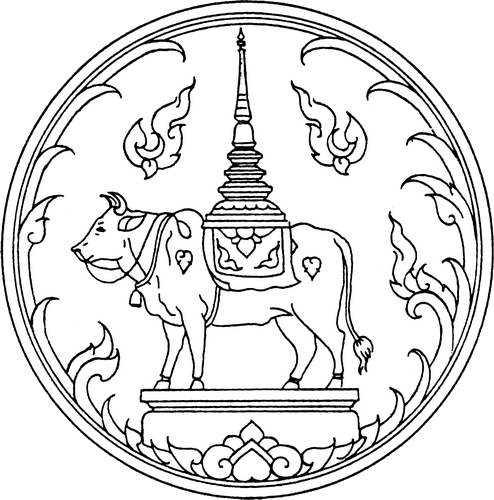
The provincial seal shows a Usuparatch bull carrying the stupa of Phrathat Chae Haeng. The buffalo goes back to a legend that the rules of Nan and Phrae were brothers, and met at a mountain to decide about the boundary between their lands. The ruler of Nan went there on a buffalo, while the ruler of Phrae went there on a horse.
The provincial tree and provincial flower is the Orchid Tree (Bauhinia variegata).
Administrative divisions
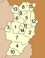
The province is subdivided in 15 districts (amphoe). These are further subdivided into 99 subdistricts (tambon) and 848 villages (muban).
Tourism
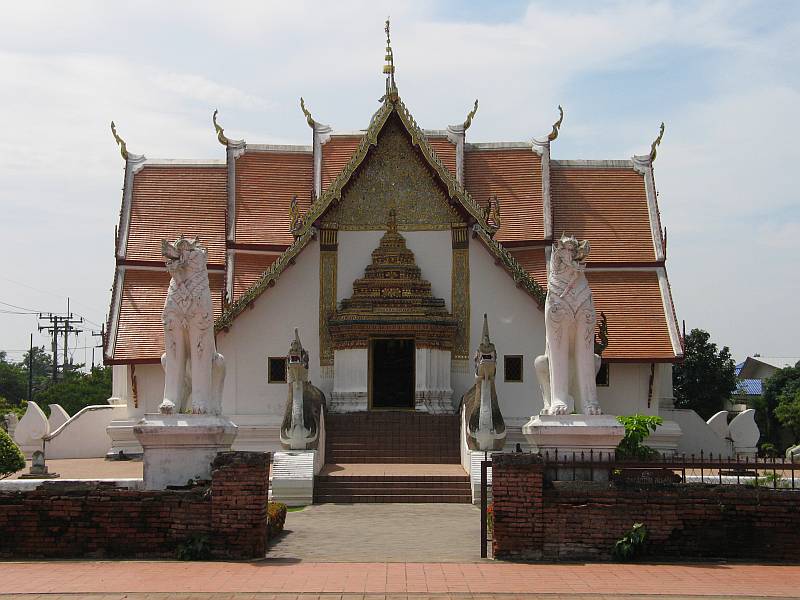
 Wat Phumin in the city of Nan
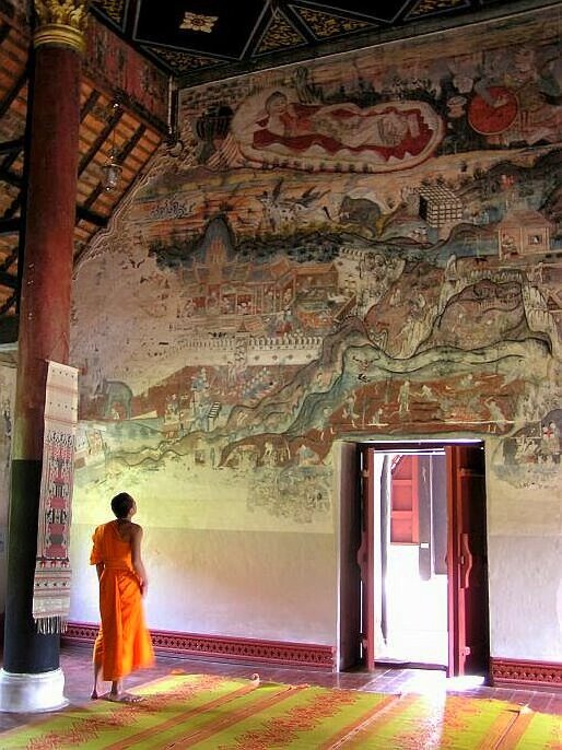
 Some of the excellent temple frescoes of Wat Nong Bua in Amphoe Tha Wang Pha
 The square based chedi of Wat Phaya Wat
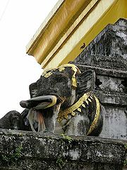 Part of the chedi of Wat Chang Kham Woravihan
 Road number 1256 (on top of the mountain ridge) snaking towards Doi Phu Kha National Park
Sights
Wat Phra That Chae Hang (วัดพระธาตุแช่แห้ง) (18°45.50'N, 100°47.50'E) It features a 55 metre-high golden Chedi containing a Holy Relic from Sukhothai. Over the Viharn's door frames and on parts of the roofs are plaster designs in the shape of Naga, the great serpent, which represent the artistic best in local architecture.
The building of the Nan National Museum (พิพิธภัณฑสถานแห่งชาติน่าน) It displays exhibitions concerning the town's history and major structures, evolution of arts in different ages, and numerous ancient objects, the most eminent of which is the Black Ivory.
Wat Phaya Wat (วัดพญาวัด) (18°46.22'N, 100°45.75'E) An ancient religious site, it has rectangular Chedi bases on which Buddha states are placed around the Chedi structure. Combined artistic influences of Lanna, Lan Chang and native Nan can be detected.
Opposite the Nan National Museum is Wat Chang Kham Woravihan (วัดช้างค้ำวรวิหาร) (18°46.59'N, 100°46.32'E) Its main features are the sculpted upper halves of elephants adorning around the Chedi, a Sukhothai influence.
Wat Suan Tan (วัดสวนตาล), built in 1230, features an old, beautifully-shaped Chedi and houses a huge bronze Buddha statue, Phra Chao Thong Thip cast by a king of Chiang Mai in 1450.
Pha Chu, or Pha Cheot Chu (ผาเชิดชูหรือผาเชิดชู), is a cliff located within the Si Nan National Park (อุทยานแห่งชาติศรีน่าน) which covers extensive forested and mountainous areas. A national flag pole has a lanyard running all the way down to the foot of the hill, the longest in the country.
Hom Chom (ฮ่อมจ๊อม) The site is characterised by a large earthen mould eroded by the elements through the ages, leaving only hard eastern columns, whose exotic shapes and forms can be interpreted as differently as the imagination goes.
The Thai Lu Village-Ban Nong Bua (หมู่บ้านไทยลื้อบ้านหนองบัว) The Thai Lu people living at Ban Nong Bua are noted or producing the traditional tribal fabric, an art handed down from generation to generation.
Wat Nong Bua (วัดหนองบัว) (19°05.34'N, 100°47.11'E) was built by Thai Lu craftsmen who had early migrated from southern China. Apart from the Viharn which is adorned with elaborate carvings, there are also wall murals painted by Thai Lu artists some one hundred years ago.
Wat Phrathat Beng Sakat (วัดพระธาตุเบ็งสกัด) The main Buddha image is in the local style residing on the so-called Chukkachi base. The back of the Buddha image is decorated with a mirror in accordance with the Thai Lue belief.
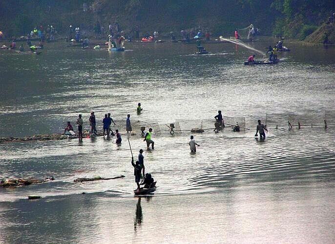
Ban Pak Nai (บ้านปากนาย) is a fishing village on the bank of the fresh-water lake above the Sirikit Dam in Uttaradit province.
For more information on interesting sites within or near the city of Nan see the Wikipedia article on "Nan, Thailand"
Local Products
The Woven Materials of Nan (ผ้าทอพื้นเมืองน่าน) are distinctively different in terms of designs and production methods from other localities. The most famous pattern is the Lai Nam Lai (ผ้าลายน้ำไหล) which resembles waves or stairs. Other designs also reflect the local artistic and creative skills. The materials are used for making dresses, colourful satchels and Tung, a type of pennant used in religious rites.
Nan is also noted for making musical instruments which include the Saloh (สะล้อ), a violin-like instrument, and the Sung (ซึง), similar to a guitar. They are used in bands which can still be heard in certain restaurants .
Silverware, wood carving and hilltribe handicraft
The leading agricultural produce is the Som Si Thong (golden oranges) (ส้มสีทอง) which are of the same species as oranges of the Central Plain. Because of climatic differences, the local version is golden-skinned and more aromatic. They are in season in December.
Culture
Festivals
Wai Phrathat Festival (งานประเพณีไหว้พระธาตุ) Nan is a town in the Lanna kingdom where Buddhism spread for a long period of time. Within the area of the ancient city, both in Mueang Nan and in Amphoe Pua, lie Phrathats on the hill. Every year, festivals paying respect to the important Phrathats are organized as follows:
Namatsakan Phrathat Beng Sakat Fair (งานนมัสการพระธาตุเบ็งสกัด) is organized on the full night of the 4th northern lunar month (around January).
“Hok Peng Waisa Mahathat Chae Haeng” Fair (งานประเพณี “หกเป็งไหว้สามหาธาตุแช่แห้ง”) takes place on the full moon night of the 6th northern lunar month or the 4th central lunar month (around the end of February-March). Sky rockets are fired as an offering to the Buddha.
“Namatsakan Phrathat Khao Noi” Fair (งานประเพณีนมัสการพระธาตุเขาน้อย) takes place on the full moon night of the 8th northern lunar month or the 6th central lunar month (around May). In the festival, there is a ceremony paying respect to Phrathat Khao Noi and sky rockets are fired as an offering to the Buddha.
“Namatsakan Song Nam Phrachao Thongthip” Fair (งานประเพณีนมัสการสรงน้ำพระเจ้าทองทิพย์) at Wat Suan Tan during the Songkran festival on 12-15 April.
Tan Kuai Salak, Hae Khua Tan or Khrua Than Festival (งานตานก๋วยสลาก หรืองานแห่คัวตาน หรือ ครัวทาน) Than Salak or Kuai Salak is an ancient tradition created in the Buddha’s time. For the northern people, it is considered as a major local merit making ceremony possessing local uniqueness. Monks are invited to receive the offerings by drawing lots.
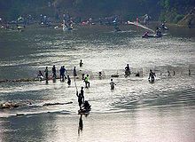
Nan Boat Races (งานประเพณีแข่งเรือจังหวัดน่าน) has been passed on for a long period of time. In 1936, boat racing was organized during the community’s robe presentation to the monks after the end of the Buddhist Lent until the time of the royal robe presentation ceremony. Nowadays, it is around mid-October or at the beginning of November every year. The opening of the races is the date when the food offerings are presented to the priests by drawing lots of Wat Chang Kham Worawihan, a royal temple. The food offering ceremony will be firstly organized. Therefore, the Nan Boat Races have come together with the Tan Kuai Salak of Wat Chang Kham until nowadays. Later, the province added the celebration of the black elephant tusk which is the precious treasure of Nan as well. Moreover, there is boat racing at Amphoe Wiang Sa in the Tan Kuai Salak Festival.
Further reading
- Filbeck, D. (1978). T'in: a historical study. Pacific linguistics, no. 49. Canberra: Dept. of Linguistics, Research School of Pacific Studies, Australian National University. ISBN 0858831724
- Goodden, Christian. Hinterlands: Sixteen New Do-It-Yourself Jungle Treks in Thailand's Nan & Mae Hong Son Provinces. Halesworth, England: Jungle Books, 2001. ISBN 0952738333
- Scholten, J. J., and Wichai Boonyawat. Detailed Reconnaissance Soil Survey of Nan Province. Kingdom of Thailand, Soil Survey Division, 1972.
External links
- Province page from the Tourist Authority of Thailand
- Golden Jubilee Network province guide
- Nan provincial map, coat of arms and postal stamp

Phayao Province Sainyabuli Province,  Laos
Laos
 Nan Province

Phrae Province Uttaradit Province Provinces of Thailand Capital: BangkokNorth North-East Amnat Charoen · Bueng Kan · Buri Ram · Chaiyaphum · Kalasin · Khon Kaen · Loei · Maha Sarakham · Mukdahan · Nakhon Phanom · Nakhon Ratchasima · Nong Bua Lamphu · Nong Khai · Roi Et · Sakon Nakhon · Sisaket · Surin · Ubon Ratchathani · Udon Thani · YasothonCentral Ang Thong · Chai Nat · Kamphaeng Phet · Lop Buri · Nakhon Nayok · Nakhon Pathom · Nakhon Sawan · Nonthaburi · Pathum Thani · Phetchabun · Phichit · Phitsanulok · Phra Nakhon Si Ayutthaya · Samut Prakan · Samut Sakhon · Samut Songkhram · Saraburi · Sing Buri · Sukhothai · Suphan Buri · Uthai ThaniEast West South Chumphon · Krabi · Nakhon Si Thammarat · Narathiwat · Pattani · Phang Nga · Phatthalung · Phuket · Ranong · Satun · Songkhla · Surat Thani · Trang · YalaCoordinates: 18°46′04.07″N 100°46′56.74″E / 18.7677972°N 100.7824278°E
Categories:


Wikimedia Foundation. 2010.