- Chumphon Province
-
Chumphon
ชุมพร— Province — Typhoon damage in Chumphon province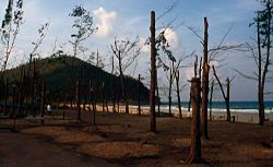
SealMap of Thailand highlighting Chumphon Province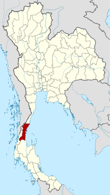
Country  Thailand
Capital Chumphon Government - Governor Karan Supphakitwilekhakan (since 2008) Area - Total 6,009.0 km2 (2,320.1 sq mi) Area rank Ranked 38th Population (2000) - Total 446,206 - Rank Ranked 57th - Density 74/km2 (191.7/sq mi) - Density rank Ranked 59th Time zone Thailand Standard Time (UTC+7) ISO 3166 code TH-86 Chumphon (Thai: ชุมพร (Pronunciation)) is one of the southern provinces (changwat) of Thailand, at the shore of the Gulf of Thailand. Neighboring provinces are (from north clockwise) Prachuap Khiri Khan, Surat Thani and Ranong. To the west it also borders the Burmese province of Tanintharyi.
Contents
Geography
Chumphon is located on the Isthmus of Kra, the narrow landbridge connecting the Malay Peninsula with the mainland of Thailand. To the west are the hills of the Phuket mountain range and its northern continuation, the Tenasserim chain, while the east is the more flat land at the coat to the Gulf of Thailand. The main river is the Lang Suan, which originates in Phato district.
History
The southern part of the province was originally a separate province named Lang Suan. It was incorporated into Chumphon in 1932.[1]
In November 1989 the typhoon Gay hit the province hard - 529 people were killed, 160,000 became homeless, 7,130 km2 (2,753 sq mi) of farm land was destroyed. Gay is the only tropical storm on record which reached Thailand with typhoon wind strength.
Etymology
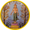
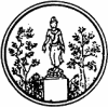
There are two different theories on the origin of the name Chumphon. According to one, it originates from Chumnumporn (lit. accumulation of forces) which derives from the fact that Chumphon was a frontier city to the Burmese. Another theory claims the name derives from a local tree named Maduea Chumphon (มะเดื่อชุมพร, Ficus glomerata), found abundant in the province. This tree is therefore also depicted in the seal of the province.[2]
Symbols
The provincial seal shows an angel giving blessings to the people standing between two Cluster Fig trees (Ficus glomerata), which is also the provincial tree. The provincial flower is the Indian shot (Canna indica), and the finger banana is another provincial symbol.
Administrative divisions
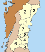
Chumphon is subdivided into 8 districts (amphoe). These are further subdivided into 70 subdistricts (tambon) and 674 villages (muban). Chumphon and Lang Suan are the two towns (thesaban mueang), there are further 12 subdistrict municipalities (thesaban tambon).
Climate
Climate data for Chumphon (1961-1990) Month Jan Feb Mar Apr May Jun Jul Aug Sep Oct Nov Dec Year Average high °C (°F) 30
(86)32
(90)33
(91)34
(93)33
(91)32
(90)32
(90)32
(90)32
(90)31
(88)29
(84)29
(84)32
(88.8)Average low °C (°F) 20
(68)20
(68)20
(68)22
(72)23
(73)23
(73)23
(73)23
(73)23
(73)22
(72)22
(72)21
(70)22
(71.3)Precipitation mm (inches) 93
(3.66)62
(2.44)56
(2.2)74
(2.91)188
(7.4)173
(6.81)174
(6.85)206
(8.11)157
(6.18)275
(10.83)380
(14.96)113
(4.45)1,951
(76.81)[citation needed] Tourism
Sights
Prince of Chumphon Shrine (ศาลเจ้าพ่อกรมหลวงชุมพร) At the shrine stands the monument of Admiral Phra Borommawong Thoe Kromluang Chumphon Khet Udomsak. There is a museum with exhibits about the admiral’s biography and things which he used. A large torpedo-ship named the Royal Chumphon is also here.
Hat Sai Ri (หาดทรายรี) This long smooth white sand and extensive beach is shaded by majestic pine trees and affords some spectacular views of nearby islands. For historical interest, a monument commemorating Admiral Prince of Chumphon is located nearby.
Khao Chao Mueang (เขาเจ้าเมือง) The district’s highest observation point offering panoramic views of the coast and far out into the distant archipelago are rivaled only by the peace and tranquility offered by the secluded beach located at the base of the mountain.
Ao Thung Makham (อ่าวทุ่งมะขาม) The bays look like a line of 2 semicircles. Roughly in the middle lies a peninsula where rocks, large and small, are scattered surround in a mysterious fashion. This peninsula serves as the bays divider.
Ko Samet (เกาะเสม็ด) One of the group of islands which belongs to the Chumphon’s National Marine Park.This island is at Mu 1 Tambon Pak Nam, about 8 km (5 mi) from Chumphon city.
The National Museum of Chumphon (พิพิธภัณฑสถานแห่งชาติชุมพร) Established in 1995 at Khao Samkaew, the museum provides an overview of province, ranging from prehistory through to the present.
Khao Phang Forest Park (วนอุทยานเขาพาง) Within the national park, there are a great variety of tropical trees, making the park a shady and restful sojourn for nature lovers and a must for students of forestry.
Wat Chao Fa Sala Loi (วัดเจ้าฟ้าศาลาลอย) At this temple lived Luang Pho Song Chanthasaro, a famous religious teacher who died at the age of nearly 100 years and his body still remains undecayed.[citation needed]
Ko Tao- there is a Ko Tao near to Chumphon town but this not to be confused with the larger inhabited Ko Tao, in the Samui-phangngan group, which is in Surat thani provence and famous for being a former political prison and now water sports haven.
Somdech Phra Srinagarindra Park (สวนสมเด็จพระศรีนครินทร์ฯ ) The park consists of a hill by a rivers. Flowers and plants decorate the area at the foot of the hill. There is also a monument to the present King’s mother.
Tham Khao Ngoen (ถ้ำเขาเงิน) The cave’s interior looks like a big hall or tent. There is a chimney going through the top. The cave’s wall is also inscribed with his Majesty’s initial Chor.Por.Ror.
Tham Khao Kriab (ถ้ำเขาเกรียบ) There are many stalagmites inside. There is a monk residence at the foot of the hill from which 370 steps leading to the cave begin.
Ko Phithak (เกาะพิทักษ์) This island is in Tambon Bang Nam Chuet and is one kilometer from the shore. The island has beautiful rocks and many fishing villages.
Namtok Thap Chang (น้ำตกทับช้าง) This is the most beautiful waterfall in Khlong Phrao National Park. The waterfall is about 65 km (40 mi) from the city center. It is surrounded with various varieties of trees, and many different types of animals live here.
Hat Arunothai (หาดอรุโณทัย) The serene beach, is lined with pine trees affording shady resting places. There is also a shrine-memorial to Prince Chumphon erected here.
Tham Rap Ro (Wat Thep Charoen) ถ้ำรับร่อ (วัดเทพเจริญ) This foothill temple cave actually consists of two adjacent caves, Ai Tay and Sai, which are both, according to legend, purported to contain hidden treasure, The Ai Tay Cave houses an old Buddha image known affectionately as Luang Pho Lak Mueang, or the town god’s revered grandfather.
Hin Chang Spirit House (ศาลเจ้าพ่อตาหินช้าง) Between kilometers 453 and 454 on the Phetchakasem highway in Mu. 2 Tambon Salui, a spirit house was installed for the revered god of the stone elephant image.
Wat Tha Kwan Mueang (วัดท่าควนเมือง) It is a fascinating temple perched on top of a limestone hill. Besides possessing a commanding view amid tranquil surrounding, the temple’s stupas house revered Buddha’s relics.
Wat Phra Thart Sawi (วัดพระธาตุสวี) At the front of the temple next to Sawi River stands a shrine where a human-size effigy is kept. People in Sawi District call this shrine “San Phra Suea Mueang”
Hat Sai Ri Sawi (หาดทรายรี สวี) It is the most beautiful in the district. It is in Mu 8, Tambon Tha Hin. It is a large sand beach parallel to a long line of many coconut trees.
Tham Thip Prida (ถ้ำทิพย์ปรีดา) This area is a rocky mountain with a stream flowing past the front. This mountain has about 40 beautiful caves, some of which contain pools.
Ko Khai ( เกาะไข่) The island’s beauty, however, lies below the surface of the crystal clear water. It is encircled by colorful coral reefs teeming with fish and other marine life.
Hat Thung Wua Laen (หาดทุ่งวัวแล่น) is perhaps Chumphon’s most popular beach. Both native swimmers and experts will enjoy this beach as its fine white sands slope gently into the sea. Sea fans, marine flowers sponges and a tremendous variety of reef fish make the scenery below the surface of the water every bit as spectacular as the beach itself.
Ko Chorakhe( เกาะจระเข้) Although “Chorakhe” means “crocodile” in Thai.
Ko Ngam Yai and Ko Ngam Noi (เกาะง่ามใหญ่และเกาะง่ามน้อย) This pair of adjacent islands is located 17 kilometers off the southern part of Thung Wua Laen Bay. It is known among locals for the swallows’ nests which are harvested there for export.
Namtok Heo Lom (น้ำตกเหวโหลม) These scenic falls are a perfect fresh water adjunct to Chumphon’s beaches and islands.
Khlong Ruea Homestay (โฮมสเตย์บ้านคลองเรือ) The home stay surrounded by rainforest. Learn to the way of life the villager and nature.
Por Ta Chongdong Summit (ยอดเขาพ่อตาโชงโดง) is about 1,000 meters high from the sea and cover with the very old ancestors. This summit is the natural place for study the biology and ecology of the rainforest, and good point to see Mos, Fern, and sunset viewpoint of Andaman sea.
Por Ta Mangkre Summit (ยอดเขาพ่อตามังเคร) covers with the green filed, wide life animals and the beautiful Mangkre flower.
Khao Thung-Klong Pi waterfall (เขาทุ่ง-น้ำตกคลองปิ) This large mountain is the main waterway of Lang Suan river. Almost area still be the fully rainforest, and enjoy the beautiful view point 50 meters in height of Khlong Pi waterfall.
Haew Ta Jan-Haew Phlu Nang waterfall (น้ำตกเหวตาจันทร์-น้ำตกเหวพลูหนัง) A walking trip to see the fresh atmosphere, natural, and gully.
Watershed forest mountain (สัมผัสยอดเขา) Hiking trail to the top of mountain in the forest of Phato. Overview looking to the both side of Andaman sea and Ao Thai (Gulf of Thailand).
Tham Khao Plu Hot Spring (บ่อน้ำร้อนถ้ำเขาพลู) There are 3 hot spas here at the foot of the mountain slope. In the vicinity, there are also 4 caves with beautiful stalactites and stalagmites. Wildlife such as squirrels, pig-tailed monkeys and birds of different species are scattered around the area.
Hat Tawan Chai (หาดตะวันฉาย) This is a large long beach parallel to the line of coconut palms.
Activities
Raptor Watching Festival (เทศกาลดูเหยี่ยวอพยพ) In the southern coastline of Chumphon, especially in October every year, the raptors flew pass Thailand to Malaysia, Singapore, Indonesia or to Australia. Specifically, Chumphon, Thailand.
Visit Fruits Garden (เยี่ยมชมสวนผลไม้) A variety of tropical fruit gardens, Such as orange (Cho-gun), Papaya, Mangoesteen, Durian, Dragon fruits, and orchid flower garden.
Snorkeling and Diving (ดำน้ำชมปะการัง) There are 44 islands located of coral reef range, Amazing with beautiful sea-world in Gulf of Thailand (Ao Thai).
Hiking trail and white water rafting in Phato (เดินป่าและล่องแพ อำเภอพะโต๊ะ) In the rainforest of Phato. It is the beginning of river. Which runs through pass the mountain, fruits gardens, to Lang Suan river.
Fireflies Sightseeing (ล่องเรือชมหิ่งห้อย) The both side of Thatapao river. When the sundown from the day. This river covered with the fireflies stayed on Lamphu tree and other trees along the river. It seem to be a great magic light from these bugs.
Bird Watching (ดูนก) Chumphon province connected conastline, Therefore many kinds of bird are living in the mangrove forest are and also flying pass this coastline from Thailand to Malaysia, Indonesia or Singapore.
IPSC Shooting Sport (ยิงปืนระบบรณยุทธ) Extremely sport, shooting game in Chumphon. It provides the shooting stadium (outdoor-indoor), restaurant, swimming pool, fitness center and the professional trainer. Located Arparkorn Rd. (Mueang Chumphon-Hat Thungwaulaen, Pathio), 2 km (1 mi) from the Government center of Chumphon.
Local Products
Fresh Fruits and Fruit Products Coffee bean Seafood Dried Spa Cashew Nut Bakery Artificial Flowers
Culture
Festivals
Phato Rafting (งานเทศกาลล่องแพพะโต๊ะ) Held during February to April. Highlights include competitions’ mini-marathon race and rafting.
Lang Suan’s Fruits Fair (งานวันผลไม้เมืองหลังสวน) This fair is organized annually around August. The fruit market here exhibits a variety of fruits and there is a fruits contest.
Traditional Boats Procession and Boat Race (งานประเพณีแห่พระแข่งเรือ) Originally, this event began in King Rama III’s period around 1844. The festival, commencing annually in October, comprises boats beautifully decorated and carrying Buddha images from various temples.
Celebration in Honouring Prince of Chumphon Shrine (งานเทิดพระเกียรติ กรมหลวงชุมพรเขตรอุดมศักดิ์) Held annually during December 19-25th, honours the Father of the Royal Thai Navy, Admiral Krom Luang Chumphon Khet Udomsak, whose life and work has been exhibited in this fair.
Chumphon Sea-World Fair (งานเปิดโลกทะเลชุมพร) The Fair is to promote local incomes and tourism as well as to conserve the natural resources of Chumphon. It is annually held in March at Hat Sai Ri. The activities include a fishing competition, exhibition and contest of pictures of related interesting places as well as mini marathon racing contest etc.
Chumphon King’s and Princess’cups boats race (งานแข่งเรือยาวชิงถ้วยพระราชทานพระบาทสมเด็จพระเจ้าอยู่หัวและสมเด็จพระเทพรัตนราชสุดาฯ สยามบรมราชกุมารี) Held annually on August at the Khlong Hua Wang-Phanang Tak, Tambon Na Cha-ang around Nong-Yai area. Boats competing the race for the King’s and the Princess’s cups are beautifully decorated and are from different parts of the country.
References
- ^ "พระบรมราชโองการ ประกาศ ยุบรวมท้องที่บางมณฑลและบางจังหวัด" (in Thai). Royal Gazette 48 (0 ก): 576–578. February 21, 1932. http://www.ratchakitcha.soc.go.th/DATA/PDF/2474/A/576.PDF.
- ^ Chumporn Travel Guide Information Archived August 20, 2007 at the Wayback Machine
External links
- Province page from the Tourist Authority of Thailand
- Official homepage (Thai only)
- Chumphon provincial map, coat of arms and postal stamp

Tanintharyi Region,  Myanmar
Prachuap Khiri Khan Province Ranong Province 
Gulf of Thailand  Chumphon Province

Surat Thani Province Provinces of Thailand Capital: BangkokNorth North-East Amnat Charoen · Bueng Kan · Buri Ram · Chaiyaphum · Kalasin · Khon Kaen · Loei · Maha Sarakham · Mukdahan · Nakhon Phanom · Nakhon Ratchasima · Nong Bua Lamphu · Nong Khai · Roi Et · Sakon Nakhon · Sisaket · Surin · Ubon Ratchathani · Udon Thani · YasothonCentral Ang Thong · Chai Nat · Kamphaeng Phet · Lop Buri · Nakhon Nayok · Nakhon Pathom · Nakhon Sawan · Nonthaburi · Pathum Thani · Phetchabun · Phichit · Phitsanulok · Phra Nakhon Si Ayutthaya · Samut Prakan · Samut Sakhon · Samut Songkhram · Saraburi · Sing Buri · Sukhothai · Suphan Buri · Uthai ThaniEast West South Chumphon · Krabi · Nakhon Si Thammarat · Narathiwat · Pattani · Phang Nga · Phatthalung · Phuket · Ranong · Satun · Songkhla · Surat Thani · Trang · YalaCoordinates: 10°29′34″N 99°10′45″E / 10.49278°N 99.17917°E


Wikimedia Foundation. 2010.