- Chanthaburi Province
-
Chanthaburi
จันทบุรี— Province — 
SealMap of Thailand highlighting Chanthaburi Province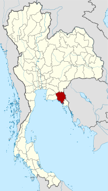
Country  Thailand
Capital Chanthaburi Government - Governor Phunsak Pranutnoraphan (since 2008) Area - Total 6,338.0 km2 (2,447.1 sq mi) Area rank Ranked 34th Population (2000) - Total 480,064 - Rank Ranked 52nd - Density 75.7/km2 (196.2/sq mi) - Density rank Ranked 56th Time zone Thailand Standard Time (UTC+7) ISO 3166 code TH-22 Chanthaburi (Thai: จันทบุรี) is a province (changwat) of Thailand. It is located in the east of Thailand, at the border to Battambang and Pailin of Cambodia and the shore to the Gulf of Thailand. The neighboring provinces are Trat in the east and Rayong, Chonburi, Chachoengsao and Sa Kaeo.
Contents
Etymology
The word Chantha originates from the Sanskrit word Chandra meaning moon, and the word buri from Sanskrit Puri meaning town or city. Therefore, the province name literally means Moon City.
History
After the Paknam crisis in 1893 the French colonist troops occupied Chanthaburi, returning it in 1905 when Thailand gave up ownership of the western part of Cambodia. A significant minority of Chanthaburi citizens are native Vietnamese, who came there in three waves - first in the 19th century during an anti-Catholic persecution in Cochin China, a second wave came in the 1920s to 1940s fleeing from French Indochina, and a third one after the communist victory in Vietnam in 1975. Thus the town of Chanthaburi is the seat of a Bishop of Chanthaburi since 1944.
Geography
 Quiet street in Amphoe Laem Sing
While the southern part of the province is located at the shore to the Gulf of Thailand and thus is mostly coastal alluvial plains, the hinterlands of the province are quite mountainous. The Chanthaburi mountain range in the north has the highest elevation of the province, the 1556 m high Soi Dao Nua Peak. The main river of the province is the Chanthaburi River.
Together with the neighboring province Trat, Chanthaburi is the center of gemstone mining, especially rubies and sapphires. Tropical fruits are also among the main products of the province. In 2000, it produced nearly 380,000 tons of durian, which was 45.57% of Thailand's durian production and approximately 27% of the world production of this fruit.[1][2]
Symbols
The provincial seal shows the moon surrounded by an aura. Inside the moon disc is a rabbit, as in Thai tradition the dark areas on the moon (maria) form a rabbit shape.
The seal symbolizes the peace and tranquility of the province. The moon also refers to the province name, which mean City of Moon.
The flag of the province also shows the seal in the middle - a white rabbit on the yellow moon disc, on a blue disc. The background of the flag is red, with the name of province in yellow written below the seal.
The provincial tree is Diospyros decandra, the provincial flower is an orchid.
The provincial slogan is Magnificent Waterfalls, Fruit City, Good Breeding Peppercorns Loads of Gems, Chanthabun Mat, Fertile Nature, Gathering Place of King Taksin the Great’s Liberation Army
Administrative divisions
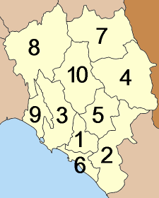
 Map of Amphoe
The province is subdivided in 10 districts (amphoe). These are further subdivided into 76 subdistricts (tambon) and 690 villages (muban).
Tourism
Sights
King Taksin the Great Shrine (ศาลสมเด็จพระเจ้าตากสินมหาราช): The shrine is a nonagonal building with a roof taking the shape of a royal hat with a pointed spire constructed in 1920 A.D. It houses a statue of King Taksin the Great to whom a large number of people come to pay respect each day.
City Pillar Shrine (ศาลหลักเมืองจันทบุรี): The shrine is assumed to have been originally built of laterite though it is unknown how it looked like. The present shrine and city pillar were constructed in 1981 and have undergone restoration.King Taksin the Great Monument (พระบรมราชานุสาวรีย์สมเด็จพระเจ้าตากสินมหาราช): The monument of King Taksin the Great accompanied by his 4 trusted soldiers in memorial of the historic liberation of the Kingdom of Ayutthaya is situated on an islet in the middle of the swamp.
Si Chan Road (ถนนศรีจันทร์) is the commercial area and centre of gem business. Even though actual gem-mining in the province is not as extensively as it used to be, Chanthaburi remains a major centre for gem dealings with stones from neighbouring countries and abroad being bought and sold.Wat Phai Lom (วัดไผ่ล้อม) Concerning the architecture, the building is surrounded by a boundary wall in four directions with an entrance on each side. Behind the temple, there is a corridor supported by five pillars without decorative capitals. The building’s base line is straight, and there is a pagoda with twelve-redented corners within the wall.
The Catholic Church Chanthaburi (โบสถ์คาทอลิกจันทบุรี หรือ อาสนวิหารพระนางมารีอาปฏิสนธินิรมล): According to history, the construction of this old and large Catholic Church took 275 years to complete. It was built into the Gothic architecture with beautiful stained glass decorations depicting Christian saints.
Wang Suan Ban Kaeo (วังสวนบ้านแก้ว) The palace used to be a royal residence of Queen Rambhai Barni, the Royal Consort of King Rama VII. It also served as the Queen’s office and demonstration centre where plants were grown and animals raised for the local people.
Wat Phlap (วัดพลับ) The hall was also used as the place to hold the Ceremony of Murathaphisek or making sacred water - water for pouring over the king’s head in the coronation ceremony or other royal rituals - at the beginning of the Chakri Dynasty. Furthermore, behind the temple, there used to be a “Sam Sang”, an ancient crematorium which is believed to have remained only in this temple.Wat Thong Thua (วัดทองทั่ว) is the site of an ancient Bot which was built over a Khmer-style temple. It also has a large collection of ancient Khmer sculptures. Nearby is the Mueang Phaniat archaeological site with its remains of laterite base of a large Khmer religious sanctuary and moats marking the town limit the south.
Boran Sathan Mueang Phaniat (โบราณสถานเมืองเพนียด) It is assumed that this monument might be the original settlement of Chanthaburi City in an early age, about a thousand years ago. Nowadays, only a ruined sandstone wall and an unidentified earth mound with a height of about 1 - 3 metres remains.
Wat Bot Mueang (วัดโบสถ์เมือง): It is believed to have been constructed in the late Ayutthaya period as evident from its white sandstone boundary markers as well as ordination hall (Phra Ubosot) and Ceylonese bell-shaped Chedi. The temple also houses a lintel of the late Baphuon style (967–1080 A.D.) depicting the God Indra on his Airavata elephant in a niche.
King Taksin Shipyard (อู่ต่อเรือพระเจ้าตาก) or Samet Ngam Shipyard (อู่ต่อเรือเสม็ดงาม): From underwater archaeological excavations and examination, several rectangular dock-like areas were found along the shore as well as parts of an old ship believed to be a three-masted Chinese junk using a rudder and measuring 24 metres long and 5 metres wide.
Boran Sathan Khai Noen Wong (โบราณสถานค่ายเนินวง) The camp space contains an area of the Underwater Archaeology Unit, Fine Arts Department, a storage place of artefacts and pottery taken from the Australian Tide Ship, which trespass Thailand’s waters in the Gulf of Thailand to illegally transport antiques out of the country.
Panichnavee National Museum (พิพิธภัณฑสถานแห่งชาติพาณิชย์นาวี): Located within Noen Wong Fort, the 2-storeyed twin building puts on an exhibition on Thai merchant marine as evidenced by over 20 years of underwater archaeological studies.Chedi Yot Khao Phloi Waen (เจดีย์ยอดเขาพลอยแหวน): The round Ceylonese-style Chedi contains the Lord Buddha’s relic. There is also a Mondop housing the Buddha’s footprint built in 1928 to replace the original one that had been broken.
Wat Takat Ngao (วัดตะกาดเง้า): It contains a scripture hall or Ho Trai built in the middle of a pond by an artisan of the royal school toward the end of King Rama III’s reign.
Khao Laem Sing Forest Park (วนอุทยานเขาแหลมสิงห์): It covers a total land and marine area of 9,500 rai, including dry evergreen forest and beach forest which are home to important flora and fauna. Marine life can be found on beaches and islands.
Khao Laem Sing (เขาแหลมสิงห์) a small hill located 172 metres above sea level, with a pile of rocks that look like a crouching lion at the front and that gave it the name Khao Laem Sing or the hill of a lion cape.
In front of Ao Krathing is Ko Nom Sao (เกาะนมสาว), which covers an area of approximately 150 rai of wild and densely growing plants. There are steep cliffs in the south, and beaches and coral reefs of some 500 metres long ideal for diving in the north.
Ao Yang (อ่าวยาง) a small shady beach near Ao Krathing.
Ko Chula (เกาะจุฬา) a small island with beautiful corals.
Hat Khung Wiman (หาดคุ้งวิมาน): Located 50 Kilometres from Chanthaburi in Amphoe Na Yai Am.
Laem Sadet–Ao Khung Kraben (แหลมเสด็จ–อ่าวคุ้งกระเบน): Ao Khung Kraben also accommodates the royally-suggested Ao Khung Kraben Development Study Centre which won the Thailand Tourism Awards 2002. The centre is responsible for research and study for appropriate development guidelines of Chanthaburi’s shoreline.
Ao Khung Kraben Non-hunting Area (เขตห้ามล่าสัตว์ป่าอ่าวคุ้งกระเบน): The area suffered deforestation 40 years ago and has just recently seen pioneer plants. There are 4 types of forest within the area; namely, dry evergreen forest, mixed deciduous forest, beach forest and mangrove forest.
Hat Chao Lao (หาดเจ้าหลาว): Located 19 Kilometres from Amphoe Tha Mai next to Hat Laem Sadet.Laem Sadet Arboretum (สวนรุกขชาติชายหาดแหลมเสด็จ): 25 Kilometres from Amphoe Tha Mai, the picturesque small beach is shady with pine trees and several beach plants.
Khao Chamao–Khao Wong National Park (อุทยานแห่งชาติเขาชะเมา–เขาวง) the headwater of Lam Nam Prasae–Rayong’s principal river, covering a total area of approximately 83 square kilometres in Amphoe Khao Chamao, Rayong Province, and Amphoe Kaeng Hang Maeo, Chanthaburi Province.
Tham Khao Wong (ถ้ำเขาวง): surrounded by limestone mountains and evergreen forest which is a habitat of Chan Pha (Dracaena loureiri Gagnep.)–an endangered species of wild animal. More than 80 caves have been discovered in this area with a complex of some 20 connected caves divided into 3 zones.
Wat Khao Sukim (วัดเขาสุกิม): The objective of the temple is to be used as a meditation venue. The temple also houses a large collection of religious items and valuable antiques donated by the public. On display are wax sculptures of over twenty Buddhist monks highly revered by the public.
Khao Khitchakut National Park (อุทยานแห่งชาติเขาคิชฌกูฏ): Its moist evergreen forests, hill evergreen forest as well as deciduous forest abound in various herbs, wild orchids, and the rare eaglewood. Its mountainous area provides home for copious wild animals. Places of interest within the national park include:
Namtok Krathing (น้ำตกกระทิง) a large 13-tiered waterfall originating from the Khitchakut Range. There are bamboo forests and various plant species along the way, with a blanket of moss and ferns on both sides. There is also a large beach formed by sand washed down by a flash flood in 1999.
Yot Khao Phrabat (ยอดเขาพระบาท) Interesting spots on top of Khao Phrabat are formed by geological phenomena and related to Buddhist legends such as Sila Chedi, the Buddha’s footprint, stone in the shape of an overturned alms bowl, Tham Ruesi or hermit cave, God Indra’s carriage racing ground, and stones in the shape of a giant turtle and elephant.
Namtok Khlong Chang Se (น้ำตกคลองช้างเซ) located some 10 Kilometres from the national park’s headquarters on the way up the Khao Phrabat. It is a circular nature trail starting from the Safeguard Unit.
Namtok Khlong Krasan (น้ำตกคลองกระสัน) a large waterfall amid shady surroundings located near Safeguard Unit 2 (Khlong Phaibun) 8 Kilometres from the national park’s headquarters.Chanthaburi Herbal Garden (สวนสมุนไพรจันทบุรี) an agency under the Medical Science Department, Ministry of Public Health, located 25 Kilometres from Chanthaburi provincial town.
Khiri Than Dam (เขื่อนคีรีธาร) is a multi-purpose dam for electricity generation, irrigation, fishery, as well as, prevention and alleviation of floods in the rainy season. Its highest altitude for water is 205 metres from sea level, with a carrying capacity of approximately 76 million cubic metres.
Chong Phakkat Thai-Cambodian Border Market (ตลาดชายแดนไทย-กัมพูชา ช่องผักกาด) located at Ban Khlong Yai, Mu 4 Tambon Khlong Yai, 30 Kilometres from Pong Nam Ron District Office, 20 Kilometres from Pailin and 68 Kilometres from Preah Tabong in Cambodia.
Ban Laem Thai-Cambodian Border Market (ตลาดชายแดนไทย-กัมพูชา บ้านแหลม) located at Ban Laem, Mu 4 Tambon Thep Nimit, 46 Kilometres from Pong Nam Ron District Office.
Namtok Hin Dat (น้ำตกหินดาด) The 12-tiered waterfall is surrounded by an intact evergreen forest, with its 9th-12th tiers being especially breathtaking.
Namtok Khao Soi Dao (น้ำตกเขาสอยดาว) The waterfall has 16 tiers with a large swarm of butterflies ideal for butterfly watching and plant study.
Wat Mangkon Buppharam or Wat Leng Hua Yi (วัดมังกรบุปผาราม หรือ วัดเล่งฮัวยี่) There is a reception hall and ordination hall, decorated with mosaics in different beautiful patterns.Namtok Phlio National Park (อุทยานแห่งชาติน้ำตกพลิ้ว) covering a total area of 84,063 rai with various species of flora such as Khanun Pa, Krathon Pa, Phimsen, etc., and fauna, the most frequently seen including boar, serow, mongoose, ground squirrel, Asiatic black bear, gibbon, monkey, etc. It is also home to several kinds of fish.
Namtok Khlong Narai (น้ำตกคลองนารายณ์) otherwise known as “Namtok Khao So Bap”, located some 8 Kilometres from the provincial town on the Chanthaburi – Laem Sing route.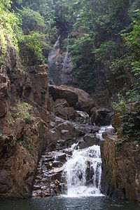 Waterfall, Namtok Phliu National Park
Namtok Phlio (น้ำตกพลิ้ว) It is a medium-scale waterfall originating from an underground stream that springs and cascades over the cliff down to a pool below. Before reaching the waterfall, there is a pool which is a natural habitat of soro brook carp that reside in the stream of waterfalls in some regions only. There are also 2 important monuments within the waterfall area including:
Alongkon Chedi (อลงกรณ์เจดีย์) built from laterite in 1876 A.D. by King Rama V in memory of the king’s and his beloved consort’s, Queen Sunantha Kumarirat, visit to the waterfall in 1874.Phranang Ruea Lom Pyramid (ปิรามิดพระนางเรือล่ม) a pyramidal stupa built from granite in 1881 in memory of the affectionate love of King Rama Ⅴtoward Queen Sunantha who was killed in a boat accident on the Chao Phraya River.
Namtok Trok Nong (น้ำตกตรอกนอง) The waterfall has 3 tiers. The 1st tier is known as “Namtok Mai Si” (Mai Si refers to bamboo). The 2nd tier is called “Namtok Klang” which is about 1 Kilometres away from the 1st tier. The 3rd tier is “Namtok Trok Nong” located about 1 Kilometres from the 2nd tier and cascades down a cliff of approximately 20 metres high.
Phuttha-utthayan Wat Chak Yai (พุทธอุทยานวัดชากใหญ่) It is a Buddhist park featuring a fine sculptural exhibition of the Life of the Lord Buddha with narrative signs.
Khuk Khi Kai (คุกขี้ไก่) was built to hold Thais who were against the French occupation of Chanthaburi in 1893. A 7-metre high, square-shaped prison, it was built in bricks with each side measuring 4.40 metres.
Tuk Daeng (ตึกแดง)' A single storey, red-tiled roof building, today it serves as the Laem Sing district public library.
Hat Laem Sing (หาดแหลมสิงห์) The beach itself is shaded with pine trees lining the entire shore and cooled by constant gentle breezes.
Oasis Sea World (โอเอซิส ซี เวิลด์) It is the place to reproduce and conserve dolphins in Chanthaburi’s watercourses.
Hot Springs (บ่อน้ำพุร้อน) 3 natural hot springs surrounded by longan and durian orchards, located 18 Kilometres from Amphoe Pong Nam Ron on Highway No. 3193.
“Manut Boran” Archaeological Site (สถานโบราณคดี “มนุษย์โบราณ”) excavation site located 25 Kilometres from Amphoe Pong Nam Ron. Prehistoric human skeletons, stone tools, artefacts, pottery and ornaments of some 4,000 years old, now removed from the pits, were unearthed.
Khao Sip Ha Chan National Park (อุทยานแห่งชาติเขาสิบห้าชั้น) or Namtok Nam Pen (น้ำตกน้ำเป็น) Places of interest include waterfalls like Namtok Saba, Namtok I Kek and especially Namtok Khao Sip Ha Chan, a breathtaking 15-tiered waterfall with water all year round.Khao Sam Ngam, 34 km from Chanthaburi.
Local Products
Gems (อัญมณี) one of the province’s renowned economic products including elaborately cut gemstones by experienced craftsmen.
Magic Ring (แหวนกล) golden rings fixed with gemstones. The setting is usually made into various animals such as shrimp, crab, fish, Naga serpent, etc. and can be separated into 4 connected rings.
Ban Samet Ngam Chanthabun Mat Weaving Centre (ศูนย์หัตถกรรมพื้นบ้านการทอเสื่อจันทบูรหมู่บ้านเสม็ดงาม) located at Tambon Nong Bua, Amphoe Mueang Chanthaburi, 7 Kilometres from the provincial city. The villagers usually weave mats out of their harvesting season. The centre also puts on exhibition various steps of reed mat weaving as well as their traditional designs.
Bang Sa Kao Mat Weaving Village (หมู่บ้านทอเสื่อบางสระเก้า) located at Tambon Bang Sa Kao, Amphoe Laem Sing, the village features a mat weaving demonstration from the beginning until the final touch when the mats are turned into various useful items such as bag, tissue box holder, place mat, letter holder, sandal, etc.
Khlum Woven Products (ผลิตภัณฑ์แปรรูปจากต้นคลุ้ม) a crafted work promoted by the Chanthaburi Provincial Skill Development Centre. Khlum is a kind of water plant with tough and strong fibre.
Ban Suan Som Furniture Market (ตลาดเฟอร์นิเจอร์บ้านสวนส้ม) located 55 Kilometres from Amphoe Pong Nam Ron, the village has been promoted for its wooden furniture such as living room suite, wardrobe, dining table, wall clock, etc.
Preserved Durian (ทุเรียนกวน) is the province’s famous processed product with a mildly sweet taste and aroma typical to each of the durian varieties.
Fruits tropical fruits like rambutan, durian, mangosteen, Rakam and Sala varieties of zalacca, santol, etc. are abundant during May –June.
Longan grow in abundance in Amphoe Pong Nam Ron, which has a similar climate to Northern Thailand, fruiting all year round, particularly during April – May.
Langsat Chamkho, sweet and not too large in size, grown in Tambon Chamkho, Amphoe Tha Mai, fruiting during May–September.
Pepper (พริกไทย) both black and white, Chanthaburi’s major economic crop .
Sen Chan Noodle (ก๋วยเตี๋ยวเส้นจันท์) is a symbolic product of Chanthaburi with a soft and glutinous quality.
Pumpkin, durian, and taro crisps (ข้าวเกรียบฟักทอง ทุเรียน และเผือก) are cooked by the Pong Nam Ron Housewife Group. They are sweet, delicious.
Soi Dao Paper (กระดาษสอยดาว) made from the pulp of Soi Dao weed grown in abundance in Chanthaburi’s evergreen forests. Ban Kwian Hak Housewife Group in Amphoe Khlung initiated to make paper from the bark of the soft wood, fast-growing Soi Dao plant, which is similar to Sa paper but tougher and brown by its natural colour. Soi Dao paper can be made into sachets for tea or herbal beverages, or artificial flowers. The wood is used to make furniture.Culture
Festivals
Phra Phutthabat Phluang Homage-paying Fair (งานนมัสการรอยพระพุทธบาทพลวง) held on the new Mun day of the 2nd lunar month during the period of the Chinese New Year to Magha Puja (around January-March) on top of Khao Khitchakut, Tambon Phluang, Amphoe Makham. The fair features an offering ceremony to guardian angels, gilding the Lord Buddha’s footprint, and climbing up Khao Khitchakut. The tradition has been observed for generations out of a folk belief that climbers will gain high merit, in addition, to mental endurance from so doing. In the past, merit-makers had to walk on foot for a distance of some 15 Kilometres up the mountain.
Phra Phutthasaiyat Gilding Fair (งานปิดทองพระพุทธไสยาสน์) held around the period of the Chinese New Year to pay homage and gild the image of Phra Phutthasaiyat or Reclining Buddha at Wat Phai Lom and featuring Dharma preaching and various forms of entertainment.
Rajamangala Rak Lueang Chan Festival (งานราชมงคลรักษ์เหลืองจันท์) is held in February of every year at Rajamangala Institute of Technology (Eastern Campus). There will be an academic exhibition, Lueang Chanthabun Orchid Competition, and sales of agricultural products and plants.
Kwian Phrabat Tug-of-war Tradition (ประเพณีชักกะเย่อเกวียนพระบาท) held around the Songkran Festival at Wat Tapon Yai, Amphoe Khlung. This tradition has been observed for more than a century and will feature a Rot Nam Dam Hua ceremony (pouring scented water onto the hands of the elderly to seek their blessing), Kwian Phrabat or the Buddha’s footprint cart tug-of-war, and various forms of entertainment during the night.
World Durian Festival (งานมหกรรมทุเรียนโลก) held annually for 1-2 weeks in the month of May at the Triangular Na Choei Ground. The fair features contests of fruit decorated floats, beauty queens, Eastern famous fruits such as rambutan, durian, mangosteen, Rakam and Sala zalaccas and varieties of santol and Thai ridgeback dog, as well as booth displays of gems and jewellery and other farmer housewife groups.Chanthaburi Gemstone and Local Product Fair (งานเปิดโลกอัญมณีและของดีเมืองจันท์) is the largest jewellery fair in the eastern region, held during 8-12 December of every year, at the Chanthaburi Gems Centre, on Tri Rat and Chanthanimit Roads.
King Taksin the Great Commemoration Day and Chanthaburi Red Cross Fair (งานวันสมเด็จพระเจ้าตากสินมหาราชรำลึก และงานกาชาดจังหวัดจันทบุรี) annually held from 28 December to the first week of January at the Provincial Stadium to commemorate his courageous liberation of the Kingdom of Ayutthaya. The fair will feature exhibitions by public agencies, booth display of the province’s local products, and Miss Chanthaburi Beauty Pageant.
Khao Soi Dao Tourism Festival (เทศกาลท่องเที่ยวเขาสอยดาว) held toward the end of the year at viewpoints of Soi Dao District Office and Khao Soi Dao Wildlife Sanctuary. Activities include selling of agricultural produce and OTOP products, cultural performances, Soi Dao lucky draw, and sales of the district’s famous fruits such as longan, sweet tamarind, etc.References
External links

Chachoengsao Province
Chonburi ProvinceSa Kaew Province Battambang Province,  Cambodia
Rayong Province 
Pailin Province, Cambodia Chanthaburi Province

Gulf of Thailand Trat Province Provinces of Thailand Capital: Bangkok North North-East Amnat Charoen · Bueng Kan · Buri Ram · Chaiyaphum · Kalasin · Khon Kaen · Loei · Maha Sarakham · Mukdahan · Nakhon Phanom · Nakhon Ratchasima · Nong Bua Lamphu · Nong Khai · Roi Et · Sakon Nakhon · Sisaket · Surin · Ubon Ratchathani · Udon Thani · YasothonCentral Ang Thong · Chai Nat · Kamphaeng Phet · Lop Buri · Nakhon Nayok · Nakhon Pathom · Nakhon Sawan · Nonthaburi · Pathum Thani · Phetchabun · Phichit · Phitsanulok · Phra Nakhon Si Ayutthaya · Samut Prakan · Samut Sakhon · Samut Songkhram · Saraburi · Sing Buri · Sukhothai · Suphan Buri · Uthai ThaniEast West South Chumphon · Krabi · Nakhon Si Thammarat · Narathiwat · Pattani · Phang Nga · Phatthalung · Phuket · Ranong · Satun · Songkhla · Surat Thani · Trang · YalaCoordinates: 12°36′37″N 102°06′10″E / 12.61028°N 102.10278°E


Wikimedia Foundation. 2010.