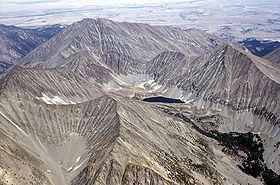
- Crazy Peak
-
Crazy Peak 
Crazy Peak at left backgroundElevation 11,214 ft (3,418 m) Prominence 7,079 ft (2,158 m) Location Location Sweet Grass County, Montana, USA Range Crazy Mountains Coordinates 46°01′04.8″N 110°16′36.6″W / 46.018°N 110.276833°W Topo map USGS Crazy Peak Climbing Easiest route Hike, scramble Crazy Peak is the highest peak in the Crazy Mountains, an isolated range of the Montana Rockies, in the United States. Crazy Peak dominates the surroundings, rising over 7,000 feet (2,133 m) above the Yellowstone River Valley, and is the highest peak in Montana north of the Beartooth Mountains, which are 50 miles (80 km) to the south. Crazy Peak is also the most topographically prominent peak in Montana.[1] A small glacier exists on the northeast slope of the mountain. The mountain is located on private land within the Gallatin National Forest.
See also
- Mountain peaks of North America
- Mountain peaks of the Rocky Mountains
- Mountain peaks of the United States
Notes
- ^ US ultra-prominences on peaklist.org
External links
- "Crazy Peak, Montana". Peakbagger.com. http://www.peakbagger.com/peak.aspx?pid=4905. Retrieved 2006-07-11.
- "Crazy Peak, USGS Crazy Peak (MT) Topo Map". TopoQuest. http://www.topoquest.com/map.asp?z=12&n=5096301&e=555984&s=50&size=l&u=7&datum=nad83&layer=DRG25. Retrieved 2008-07-04.
 State of Montana
Helena (capital) Topics Index · History · Governors · People · Geography · State Government · Delegations · Visitor Attractions
Society Crime · Demographics · Economy · Education · Politics
Regions The Flathead · Glacier National Park · Regional designations of Montana · Western Montana · Yellowstone
Largest cities Counties Beaverhead · Big Horn · Blaine · Broadwater · Carbon · Carter · Cascade · Chouteau · Custer · Daniels · Dawson · Deer Lodge · Fallon · Fergus · Flathead · Gallatin · Garfield · Glacier · Golden Valley · Granite · Hill · Jefferson · Judith Basin · Lake · Lewis and Clark · Liberty · Lincoln · Madison · McCone · Meagher · Mineral · Missoula · Musselshell · Park · Petroleum · Phillips · Pondera · Powder River · Powell · Prairie · Ravalli · Richland · Roosevelt · Rosebud · Sanders · Sheridan · Silver Bow · Stillwater · Sweet Grass · Teton · Toole · Treasure · Valley · Wheatland · Wibaux · Yellowstone
Categories:- Mountains of Montana
- Landforms of Sweet Grass County, Montana
- Montana geography stubs
Wikimedia Foundation. 2010.
