- Old North Columbus
-
Olde North Columbus commonly refers to the area north of Lane Avenue to Slate run in Glen Echo Ravine, extending east to Silver Drive and west to Olentangy River Road, including the Union Cemetery in the University District. The area includes several smaller neighborhoods within these general boundaries, including the Iuka Ravine, Indianola Forest, Oakland & Northwood Ave, and Glen Echo. In October 2009, the City of Columbus officially recognized the neighborhood by installing two "Old North Columbus" arches along N. High Street - one at Lane Avenue and the second at Arcadia Avenue. Both arches were requested by Olde North Columbus residents, through the Olde North Columbus Preservation Society and the Findley Avenue Community Watch Collaborative. [The 'e' in 'Olde' was mistakenly omitted by a city employee. The 'e' will be added into the arches in the near future.]
The University Area Commission's Community Relation's Committee voted on August 5, 2009 to recognize Olde North Columbus as a University District neighborhood within the Commission's boundaries.
Contents
The neighborhood
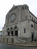
Olde North Columbus traditionally has a higher percentage of home ownership than the core campus area to the south. However, it combines the diversity and liveliness of an urban academic feel with the tranquility of a quiet family neighborhood. The area is home to four Columbus City Schools: Medary Elementary School, North High School, Indianola Middle School and the Special Needs Center, all of which are historically significant buildings. The neighborhood also has several churches, restaurants and other small businesses along High Street and Indianola Avenue.
Natural and historic features
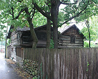
Olde North Columbus includes Slate Run, the Olentangy River (at one time called "Whetstone River"), both the Iuka and Glen Echo Ravines, and other naturally beautiful features. There are also several historic neighborhoods and buildings, including the 1806 Beers log cabin, built three years after Ohio became a state, the site of the 1814 Wilcox/Piatt/Hess/Minot Mill (only the platform on which it sat, northeast of the West Dodridge Street Bridge, remains), a horse/wagon hitch on E. Maynard Avenue, the 19th and 20th century Union Cemetery (corner of W. Dodridge Street and Olentangy Boulevard) and the Civil War Site, Camp Thomas (approx. East Avenue to Adams Avenue, Arcadia Avenue to Maynard Avenue).
External links
- Official Olde North Columbus Business and Community Website
- Olde North Columbus Preservation Society and Historic Association, Columbus, Ohio
- University Area Commission, Columbus, Ohio
- University District Organization, Columbus, Ohio
See also
Coordinates: 40°00′52″N 83°00′41″W / 40.014444°N 83.011343°W
Wikimedia Foundation. 2010.


