- National Register of Historic Places listings in Newport News, Virginia
-
This list includes properties and districts listed on the National Register of Historic Places in the independent city of Newport News, Virginia. Click the "Map of all coordinates" link to the right to view a Google map of all properties and districts with latitude and longitude coordinates in the table below.[1]
-
- This National Park Service list is complete through NPS recent listings posted November 10, 2011.[2]
[3] Landmark name [4] Image Date listed Location City or town Summary 1 Boldrup Plantation Archeological Site September 16, 1982 Address Restricted Newport News 2 Causey's Mill February 21, 2008 11700 Warwick Rd.
37°03′31″N 76°29′01″W / 37.058611°N 76.483611°WNewport News 3 Simon Reid Curtis House August 20, 2009 10 Elmhurst St.
37°11′37″N 76°34′23″W / 37.193589°N 76.572942°WNewport News 4 Dam No. One Battlefield Site August 4, 1995 13560 Jefferson Ave.
37°10′59″N 76°32′17″W / 37.183056°N 76.538056°WNewport News 5 Denbigh Plantation Site February 16, 1970 Address Restricted Newport News 6 Endview Plantation May 8, 2008 362 Yorktown Rd.
37°12′12″N 76°34′30″W / 37.203297°N 76.575022°WNewport News 7 James A. Fields House June 6, 2002 617 27th St.
36°59′05″N 76°25′19″W / 36.984722°N 76.421944°WNewport News 8 First Denbigh Parish Church Archeological Site September 7, 1982 Address Restricted Newport News 9 Fort Crafford May 17, 1974 Fort Eustis Military Reservation on Mulberry Island Point
37°07′42″N 76°37′05″W / 37.128333°N 76.618056°WNewport News 10 Greenlawn Cemetery February 5, 1999 2700 Parish Ave.
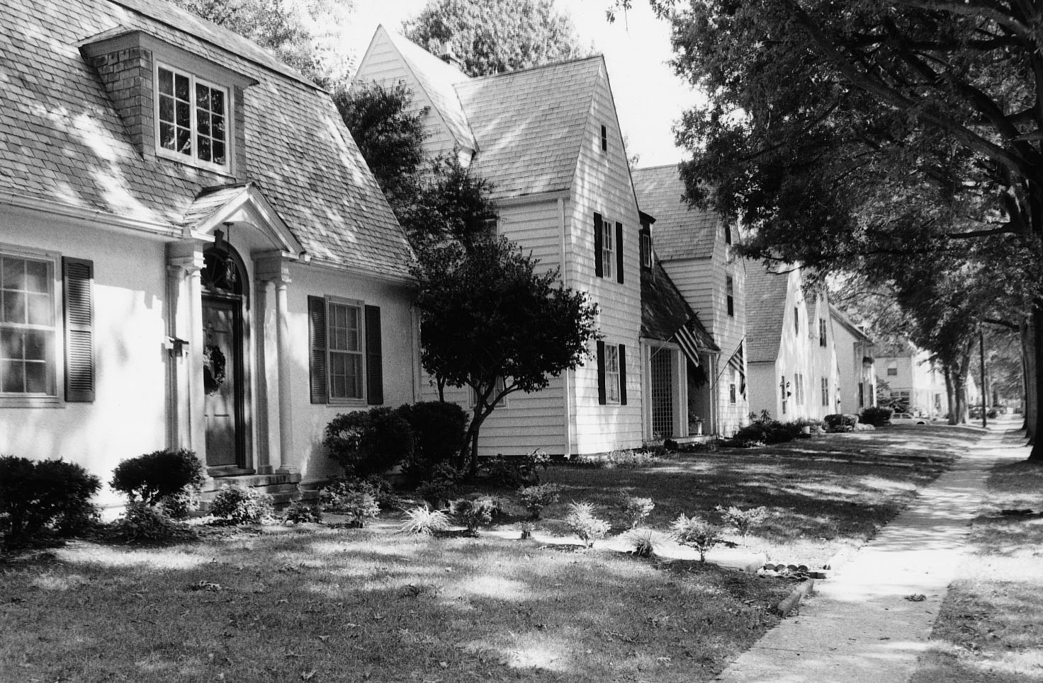
36°59′50″N 76°24′15″W / 36.997222°N 76.404167°WNewport News 11 Hilton Village 
June 23, 1969 Bounded by the James River, Post St., Chesapeake and Ohio RR tracks, and Hopkins St.
37°01′51″N 76°27′44″W / 37.030833°N 76.462222°WNewport News 12 Hotel Warwick October 4, 1984 25th St. and West Ave.
36°58′36″N 76°25′55″W / 36.976667°N 76.431944°WNewport News 13 Matthew Jones House June 11, 1969 MacAuliffe Rd. and James River Rd., Fort Eustis
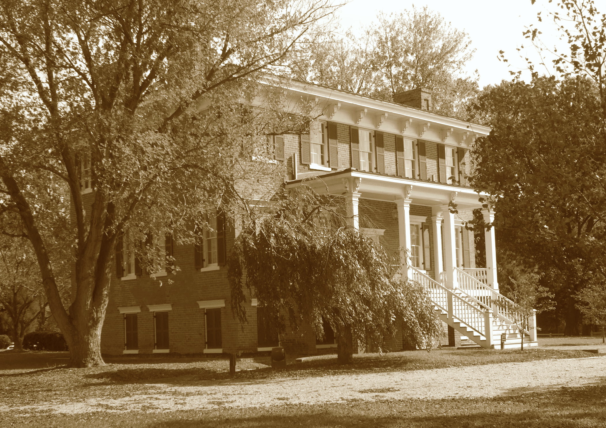
37°09′37″N 76°36′11″W / 37.160278°N 76.603056°WNewport News 14 Lee Hall 
December 5, 1972 Near jct. of U.S. 60 and VA 238
37°11′59″N 76°34′32″W / 37.199722°N 76.575556°WNewport News 15 Lee Hall Depot September 24, 2010 9 Elmhurst St.
37°11′40″N 76°34′21″W / 37.194444°N 76.5725°WNewport News 16 Lee's Mill Earthworks June 23, 2003 280 Rivers Ridge Cir.
37°10′02″N 76°33′13″W / 37.167222°N 76.553611°WNewport News 17 Medical Arts Building September 14, 2002 2901 West Avenue
36°58′47″N 76°26′04″W / 36.979722°N 76.434444°WNewport News 18 Newport News Middle Ground Light Station 
December 2, 2002 Approx. 2 mi. SSE of Newport News
36°56′42″N 76°23′30″W / 36.945°N 76.391667°WNewport News 19 Newport News Public Library August 17, 2005 2907 West Ave.
36°58′55″N 76°26′04″W / 36.981944°N 76.434444°WNewport News 20 J. Thomas Newsome House December 19, 1990 2803 Oak Ave.
36°59′23″N 76°24′18″W / 36.989722°N 76.405°WNewport News 21 Noland Company Building May 21, 2010 2600 Warwick Blvd.
36°58′50″N 76°25′36″W / 36.980494°N 76.426714°WNewport News 22 North End Historic District August 28, 1986 Roughly bounded by Sixty-eighth St., Warwick Blvd., Fiftieth St., and Huntington Ave.
37°00′02″N 76°26′30″W / 37.000556°N 76.441667°WNewport News 23 Queen Hith Plantation Complex Site February 24, 1983 Address Restricted Newport News 24 Richneck Plantation Site July 8, 1977 Address Restricted Newport News 25 Riverside Apartments July 28, 1983 4500-4600 Washington Ave.
36°59′28″N 76°26′20″W / 36.991111°N 76.438889°WNewport News 26 Skiffes Creek Sand Spit Site February 24, 1983 Address Restricted Newport News 27 Smith's Pharmacy June 6, 2002 3114 Chestnut Ave.
36°59′35″N 76°24′33″W / 36.993056°N 76.409167°WNewport News 28 Southern Terminal Redoubt February 24, 1983 Address Restricted Newport News 29 St. Vincent de Paul Catholic Church June 2, 2005 230 33rd St.
36°58′59″N 76°25′56″W / 36.983056°N 76.432222°WNewport News 30 Warwick County Courthouses November 3, 1988 Old Courthouse Way
37°07′47″N 76°32′33″W / 37.129722°N 76.5425°WNewport News 31 Whittaker Memorial Hospital September 30, 2009 1003 28th St.
36°59′14″N 76°24′45″W / 36.987242°N 76.412572°WNewport News See also
- National Register of Historic Places listings in Virginia
- National Register of Historic Places listings in York County, Virginia
- List of National Historic Landmarks in Virginia
References
- ^ The latitude and longitude information provided in this table was derived originally from the National Register Information System, which has been found to be fairly accurate for about 99% of listings. For about 1% of NRIS original coordinates, experience has shown that one or both coordinates are typos or otherwise extremely far off; some corrections may have been made. A more subtle problem causes many locations to be off by up to 150 yards, depending on location in the country: most NRIS coordinates were derived from tracing out latitude and longitudes off of USGS topographical quadrant maps created under North American Datum of 1927, which differs from the current, highly accurate GPS system used by Google maps. Chicago is about right, but NRIS longitudes in Washington are higher by about 4.5 seconds, and are lower by about 2.0 seconds in Maine. Latitudes differ by about 1.0 second in Florida. Some locations in this table may have been corrected to current GPS standards.
- ^ "National Register of Historic Places: Weekly List Actions". National Park Service, United States Department of the Interior. Retrieved on November 10, 2011.
- ^ Numbers represent an ordering by significant words. Various colorings, defined here, differentiate National Historic Landmark sites and National Register of Historic Places Districts from other NRHP buildings, structures, sites or objects.
- ^ "National Register Information System". National Register of Historic Places. National Park Service. . http://nrhp.focus.nps.gov/natreg/docs/All_Data.html.
U.S. National Register of Historic Places Topics Lists by states Alabama • Alaska • Arizona • Arkansas • California • Colorado • Connecticut • Delaware • Florida • Georgia • Hawaii • Idaho • Illinois • Indiana • Iowa • Kansas • Kentucky • Louisiana • Maine • Maryland • Massachusetts • Michigan • Minnesota • Mississippi • Missouri • Montana • Nebraska • Nevada • New Hampshire • New Jersey • New Mexico • New York • North Carolina • North Dakota • Ohio • Oklahoma • Oregon • Pennsylvania • Rhode Island • South Carolina • South Dakota • Tennessee • Texas • Utah • Vermont • Virginia • Washington • West Virginia • Wisconsin • WyomingLists by territories Lists by associated states Other  Category:National Register of Historic Places •
  Portal:National Register of Historic Places
Topics 
Parks Newport News Park • Lake Maury • King-Lincoln Park • Hilton Pier/Ravine • Denbigh Park Boat Ramp • Endview PlantationMilitary Neighborhoods City Center • Colony Pines • Christopher Shores-Stuart Gardens • Denbigh • East End • Glendale • Hidenwood • Hilton Village • Jefferson Park • Kiln Creek • Lee Hall • Menchville • Morrison • Newmarket • North End • Oyster Point • Port Warwick • Richneck • Riverside • Summerlake • Village Green • WarwickHampton Roads Metropolitan Area • Virginia • United States Categories:- Newport News, Virginia
- National Register of Historic Places in Virginia
- Virginia-related lists
-

Wikimedia Foundation. 2010.