- National Register of Historic Places listings in Cass County, Minnesota
-
This is a list of properties on the National Register of Historic Places in Cass County, Minnesota. See National Register of Historic Places listings in Minnesota.
[1] Landmark name Image Date listed Location City or town Summary 1 Battle Point (21CA12) August 17, 1990 6 mi (9.7 km) west of County Highway 8 on Leech Lake in the Battleground State Forest
47°09′52″N 94°18′33″W / 47.164444°N 94.309167°WCass Lake 2 Chase Hotel June 4, 1980 329 Cleveland Ave.
47°06′12″N 94°35′46″W / 47.103333°N 94.596111°WWalker 3 Chippewa Agency Historic District May 22, 1973 Address Restricted Pillager 4 Conservation Building January 15, 2003 205 Minnesota Ave.
47°06′05″N 94°34′41″W / 47.101389°N 94.578056°WWalker 5 Crow Wing State Park July 28, 1970 Off Minnesota Highway 371
46°16′39″N 94°20′40″W / 46.2775°N 94.344444°WPillager 6 Great Northern Railway Company Bridge October 14, 1980 Southwest of Cass Lake off Minnesota Highway 371
47°16′08″N 94°37′39″W / 47.268889°N 94.6275°WCass Lake 7 Gull Lake Mounds Site May 7, 1973 Address Restricted Pillager 8 Hole-in-the-Day House Site June 19, 1973 Address Restricted Pillager 9 Minnesota State Sanatorium for Consumptives July 25, 2001 7232 Ah-Gwah-Ching Rd., NW.
47°04′11″N 94°34′12″W / 47.069722°N 94.57°WWalker Media coverage 10 Old Backus December 24, 1974 Address Restricted Backus 11 Rice Lake Hut Rings August 14, 1973 Address Restricted Pillager 12 Sherwood Forest Lodge Complex June 16, 1980 County Highway 77
46°29′08″N 94°21′36″W / 46.485556°N 94.36°WLake Shore 13 Soo Line Depot 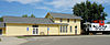
May 23, 1980 Off Main St.
47°03′25″N 93°55′05″W / 47.056944°N 93.918056°WRemer 14 Supervisor's Office Headquarters January 31, 1976 Ash Ave.
47°22′45″N 94°36′50″W / 47.379167°N 94.613889°WCass Lake 15 Winnibigoshish Lake Dam 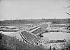
May 11, 1982 County Highway 9 at the Mississippi River
47°25′45″N 94°03′07″W / 47.429167°N 94.051944°WBena 16 Winnibigoshish Resort May 23, 1980 U.S. Route 2
47°20′45″N 94°12′30″W / 47.345833°N 94.208333°WBena References
- ^ Numbers represent an ordering by significant words. Various colorings, defined here, differentiate National Historic Landmark sites and National Register of Historic Places Districts from other NRHP buildings, structures, sites or objects.
U.S. National Register of Historic Places Topics Lists by states Alabama • Alaska • Arizona • Arkansas • California • Colorado • Connecticut • Delaware • Florida • Georgia • Hawaii • Idaho • Illinois • Indiana • Iowa • Kansas • Kentucky • Louisiana • Maine • Maryland • Massachusetts • Michigan • Minnesota • Mississippi • Missouri • Montana • Nebraska • Nevada • New Hampshire • New Jersey • New Mexico • New York • North Carolina • North Dakota • Ohio • Oklahoma • Oregon • Pennsylvania • Rhode Island • South Carolina • South Dakota • Tennessee • Texas • Utah • Vermont • Virginia • Washington • West Virginia • Wisconsin • WyomingLists by territories Lists by associated states Other Categories:- National Register of Historic Places in Minnesota by county
- Cass County, Minnesota
- Buildings and structures in Cass County, Minnesota

Wikimedia Foundation. 2010.