- Mountain peaks of Central America
-
Main article: Central AmericaSee also: Mountain peaks of North America
Contents
This article comprises three sortable tables of major mountain peaks of Central America. This article defines Central America as the seven nations of Belize, Costa Rica, El Salvador, Guatemala, Honduras, Nicaragua, and Panama.
Topographic elevation is the vertical distance above the reference geoid, a precise mathematical model of the Earth's sea level as an equipotential gravitational surface. Topographic prominence is the elevation difference between the summit and the highest or key col to a higher summit. Topographic isolation is the minimum great circle distance to a point of higher elevation.
This article defines a significant summit as a summit with at least 100 meters (328.1 feet) of topographic prominence, and a major summit as a summit with at least 500 meters (1640.4 feet) of topographic prominence. An ultra-prominent summit is a summit with at least 1500 meters (4921.3 feet) of topographic prominence.
Highest major summits
The following sortable table lists the 15 highest mountain peaks of Central America with at least 500 meters (1640.4 feet) of topographic prominence.
The first two of these summits each have at least 4000 meters (13,123.4 feet) of topographic elevation and at least 500 meters (1640.4 feet) of topographic prominence.
The 15 highest mountain peaks of Central America
with at least 500 meters of topographic prominence
Rank Mountain Peak Nation Province Elevation Prominence Isolation 1 Volcán Tajumulco[1] PB  Guatemala
San Marcos 4220 m
13,845 ft3980 m
13,058 ft722 km
448 mi2 Volcán Tacaná[2] PB Guatemala
 Mexico
San Marcos
Chiapas4067 m
13,343 ft2273 m
7,457 ft24 km
15 mi3 Volcán Acatenango PB GuatemalaChimaltenango
Sacatepéquez3975 m
13,041 ft1835 m
6,020 ft126 km
78 mi4 Alto Cuchumatanes PB GuatemalaHuehuetenango 3837 m
12,589 ft1877 m
6,158 ft65 km
40 mi5 Chirripó Grande[3] PB  Costa Rica
Cartago
Limón
San José3819 m
12,530 ft3726 m
12,224 ft864 km
537 mi6 Cerro Ventisqueros PB Costa RicaSan José 3812 m
12,507 ft>500 m
>1,640 ft2.2 km
1.3 mi7 Volcán Santa María PB GuatemalaQuetzaltenango 3772 m
12,375 ft>500 m
>1,640 ft50 km
31 mi8 Volcán de Fuego PB GuatemalaChimaltenango
Escuintla
Sacatepéquez3763 m
12,346 ft>500 m
>1,640 ft2.1 km
1.3 mi9 Volcán de Agua PB GuatemalaEscuintla
Sacatepéquez3761 m
12,339 ft1981 m
6,499 ft16 km
10 mi10 Cerro Terbi PB Costa RicaLimón
San José3720 m
12,205 ft>500 m
>1,640 ft1.5 km
0.9 mi11 Cerro Kámuk PB Costa RicaLimón 3563 m
11,690 ft>500 m
>1,640 ft54 km
34 mi12 Volcán Atitlán PB GuatemalaSololá 3537 m
11,604 ft1754 m
5,755 ft35 km
21 mi13 Montañas Peña Blanca High Point PB GuatemalaHuehuetenango 3518 m
11,542 ft1858 m
6,096 ft42 km
26 mi14 Volcán Barú[4] PB  Panama
Chiriquí 3475 m
11,401 ft>500 m
>1,640 ft74 km
46 mi15 Volcán Irazú PB Costa RicaCartago
San José3402 m
11,161 ft1872 m
6,142 ft48 km
30 miMost prominent summits
See also: List of Ultras in Central AmericaThe following sortable table lists the 15 most topographically prominent mountain peaks of Central America.
See the List of Ultras in Central America for a table of all summits with at least 1500 meters (4921.3 feet) of topographic prominence.
The 15 most topographically prominent mountain peaks of Central America
Rank Mountain Peak Nation Province Elevation Prominence Isolation 1 Volcán Tajumulco[1] PB GuatemalaSan Marcos 4220 m
13,845 ft3980 m
13,058 ft722 km
448 mi2 Chirripó Grande[3] PB Costa RicaCartago
Limón
San José3819 m
12,530 ft3726 m
12,224 ft864 km
537 mi3 Volcán Tacaná[2] PB Guatemala
MexicoSan Marcos
Chiapas4067 m
13,343 ft2273 m
7,457 ft24 km
15 mi4 Montaña de Santa Bárbara PB  Honduras
Santa Bárbara 2744 m
9,003 ft2084 m
6,837 ft74 km
46 mi5 Cerro las Minas[5] PB HondurasLempira 2849 m
9,347 ft2069 m
6,788 ft130 km
81 mi6 Volcán de Agua PB GuatemalaEscuintla
Sacatepéquez3761 m
12,339 ft1981 m
6,499 ft16 km
10 mi7 Alto Cuchumatanes PB GuatemalaHuehuetenango 3837 m
12,589 ft1877 m
6,158 ft65 km
40 mi8 Volcán Irazú PB Costa RicaCartago
San José3402 m
11,161 ft1872 m
6,142 ft48 km
30 mi9 Montañas Peña Blanca High Point PB GuatemalaHuehuetenango 3518 m
11,542 ft1858 m
6,096 ft42 km
26 mi10 Volcán Acatenango PB GuatemalaChimaltenango
Sacatepéquez3975 m
13,041 ft1835 m
6,020 ft126 km
78 mi11 Volcán San Miguel PB  El Salvador
San Miguel 2131 m
6,991 ft1831 m
6,007 ft64 km
40 mi12 Cerro Tacarcuna PB PanamaDarién 1875 m
6,152 ft1770 m
5,807 ft99 km
61 mi13 Volcán Atitlán PB GuatemalaSololá 3537 m
11,604 ft1754 m
5,755 ft35 km
21 mi14 Pico Bonito PB HondurasAtlántida 2450 m
8,038 ft1710 m
5,610 ft152 km
95 mi15 Montaña San Ildefonso PB HondurasCortés 2242 m
7,356 ft1702 m
5,584 ft68 km
42 miMost isolated major summits
The following sortable table lists the 15 most topographically isolated mountain peaks of Central America with at least 500 meters (1640.4 feet) of topographic prominence.
The first 11 of these summits each have at least 100 kilometers (62.14 miles) of topographic isolation and at least 500 meters (1640.4 feet) of topographic prominence.
The 15 most topographically isolated mountain peaks of Central America
with at least 500 meters of topographic prominence
Rank Mountain Peak Nation Province Elevation Prominence Isolation 1 Chirripó Grande[3] PB Costa RicaCartago
Limón
San José3819 m
12,530 ft3726 m
12,224 ft864 km
537 mi2 Volcán Tajumulco[1] PB GuatemalaSan Marcos 4220 m
13,845 ft3980 m
13,058 ft722 km
448 mi3 Pico Bonito PB HondurasAtlántida 2450 m
8,038 ft1710 m
5,610 ft152 km
95 mi4 Pico Mogotón[6] PB Honduras
 Nicaragua
Copán
Nueva Segovia2106 m
6,909 ft>500 m
>1,640 ft142 km
88 mi5 Doyle's Delight[7] PB  Belize
Cayo
Toledo1174 m
3,852 ft>500 m
>1,640 ft139 km
86 mi6 Volcán San Cristóbal PB NicaraguaChinandega 1745 m
5,725 ft1665 m
5,463 ft134 km
83 mi7 Cerro Hoya PB PanamaLos Santos
Veraguas1559 m
5,115 ft>500 m
>1,640 ft132 km
82 mi8 Cerro las Minas[5] PB HondurasLempira 2849 m
9,347 ft2069 m
6,788 ft130 km
81 mi9 Volcán Acatenango PB GuatemalaChimaltenango
Sacatepéquez3975 m
13,041 ft1835 m
6,020 ft126 km
78 mi10 Sierra de Agalta High Point PB HondurasOlancho 2335 m
7,661 ft1495 m
4,905 ft123 km
76 mi11 Volcán Miravalles PB Costa RicaAlajuela
Guanacaste2028 m
6,654 ft1533 m
5,030 ft103 km
64 mi12 Cerro Tacarcuna PB PanamaDarién 1875 m
6,152 ft1770 m
5,807 ft99 km
61 mi13 Volcán de San Vicente PB El SalvadorLa Paz
San Vicente2182 m
7,159 ft1562 m
5,125 ft90 km
56 mi14 Montaña los Comayagua PB HondurasComayagua 2407 m
7,897 ft1507 m
4,944 ft81 km
50 mi15 Volcán Barú[4] PB PanamaChiriquí 3475 m
11,401 ft>500 m
>1,640 ft74 km
46 miGallery
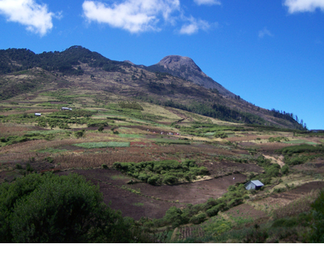
-
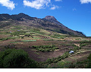
The summit of Volcán Tajumulco is the highest point of Guatemala and all of Central America.
See also
- Index of Central America-related articles
- Central America
- Belize
- Costa Rica
- El Salvador
- Guatemala
- Honduras
- Nicaragua
- Panama
- Category:Mountains of Central America
- Physical geography
- Topography
- Topographic elevation
- Topographic isolation
- Topographic prominence
- Topographic summit
- Topography
- Lists of mountains
- Mountain peaks of greater North America
- Mountain peaks of Greenland
- Mountain peaks of Canada
- Mountain peaks of the Rocky Mountains
- Mountain peaks of the United States
- Mountain peaks of Mexico
- Mountain peaks of Central America
- The 23 ultra-prominent mountain peaks of Central America
- Mountain peaks of the Caribbean
- Mountain peaks of greater North America
References
- ^ a b c The summit of Volcán Tajumulco is the highest point of the Republic of Guatemala and all of Central America.
- ^ a b The summit of Volcán Tacaná lies on the international border between Guatemala and México.
- ^ a b c The summit of Chirripó Grande is the highest point of the Republic of Costa Rica.
- ^ a b The summit of Volcán Barú is the highest point of the Republic of Panama.
- ^ a b The summit of Cerro las Minas is the highest point of the Republic of Honduras.
- ^ The summit of Pico Mogotón on the international border with Honduras is the highest point of the Republic of Nicaragua.
- ^ The summit of Doyle's Delight is the highest point of the nation of Belize.
External links
Central America Sovereign states Belize · Costa Rica · El Salvador · Guatemala · Honduras · Nicaragua · Panama

Mountain peaks of North America Sovereign states - Antigua and Barbuda
- Bahamas
- Barbados
- Belize
- Canada
- Costa Rica
- Cuba
- Dominica
- Dominican Republic
- El Salvador
- Grenada
- Guatemala
- Haiti
- Honduras
- Jamaica
- Mexico
- Nicaragua
- Panama
- Saint Kitts and Nevis
- Saint Lucia
- Saint Vincent and the Grenadines
- Trinidad and Tobago
- United States
Dependencies and
other territories- Anguilla
- Aruba
- Bermuda
- Bonaire
- British Virgin Islands
- Cayman Islands
- Curaçao
- Greenland
- Guadeloupe
- Martinique
- Montserrat
- Puerto Rico
- Saint Barthélemy
- Saint Martin
- Saint Pierre and Miquelon
- Saba
- Sint Eustatius
- Sint Maarten
- Turks and Caicos Islands
- United States Virgin Islands
Categories:- Lists of mountains by elevation
- Lists of mountains by prominence
- Lists of mountains by isolation
- Mountains of Central America
-
Wikimedia Foundation. 2010.