- Darién Province
-
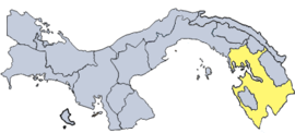
Darién is a province in eastern Panama. It is also the largest province in Panama. It is hot, humid, heavily forested, and sparsely populated, having 48,378 habitants (2010.)
Europeans first discovered the region in 1501, and Christopher Columbus sighted it on his fourth voyage in 1503.
The Spanish established the first European colony in South America, Santa María la Antigua del Darién, in Darién in 1510. The settlement did not prosper, however, and was soon abandoned. Some of the refugees from Santa María went on to found Panama City in 1519.
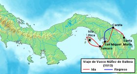
From upon a peak near Santa Maria in present-day Darién during 1513, Panama, Vasco Núñez de Balboa became the first European known to have seen the Pacific Ocean from the New World.
A few days later, after his march from Santa Maria, he and his troops reached the Pacific after traveling more than 68 miles (110 km). Balboa named the bay where they reached the sea, San Miguel, because they arrived on September 29, 1513, the feast day of the archangel Michael. He named the new sea, Mar del Sur, since they had traveled south to reach it.
In 1698, the Scots launched another attempt to colonize Darién: the Darién scheme. The disastrous financial impact of the venture's failure on the Scottish national economy led to the Acts of Union 1707, which united the Kingdom of England and the Kingdom of Scotland (previously separate states) in a single Kingdom of Great Britain.[1]
The province was formed in 1922 from Panamá province. Today, the chief town in Darién is La Palma, located where the Tuira River empties into the Bay of San Miguel.
The Darién Gap is the only gap in the Pan-American Highway along the entire length of North, Central, and South America.
Contents
Districts
Initially, Darién Province was divided into two districts:
- Chepigana District, which contains the easternmost point of Central America - Corregimientos of Chepigana include La Palma (capital), Camoganti, Chepigana, Garachiné, Jaqué, Puerto Piña, Río Congo, Río Iglesias, Sambú, Setegantí, Taimatí, Tucutí, Agua Fría, Cucunatí, Río Congo Arriba, and Santa Fe
- Pinogana District - Corregimientos of Pinogana include El Real de Santa María (capital), Boca de Cupe, Paya, Pinogana, Púcuro, Yape, Yaviza, Metetí, and Wargandi
Later, an Indigenous Territory, the comarca indígena of Emberá was established in the province on November 8, 1983. It consists of two additional districts:
- Cémaco District
- Sambú District
The comarca indígena of Kuna de Wargandí also was established in 2000. It is not subdivided into districts.
Literary reference
Darién appears in the English poet John Keats's poem On First Looking Into Chapman's Homer. Keats compares the impact of the moment when, standing on a peak in Darién, "stout Cortez" first views the Pacific Ocean with that of his own discovery of Homer's 'pure serene' demesne through the translation of George Chapman (1559-1634). (Keats is thought to have confused Balboa's discovery of the Pacific with his fellow conquistador Hernán Cortés's first sight of the Valley of Mexico).[2]
References
See also
- Darién Gap
- Darien scheme
- Mellander, Gustavo A. (1971). The United States in Panamanian Politics: The Intriguing Formative Years. Daville,Ill.:Interstate Publishers. OCLC 138568.
- Mellander, Gustavo A.; Nelly Maldonado Mellander (1999). Charles Edward Magoon: The Panama Years. Río Piedras, Puerto Rico: Editorial Plaza Mayor. ISBN 1-56328-155-4. OCLC 42970390.
Pinogana District El Real de Santa María · Boca de Cupe · Paya · Pinogana · Púcuro · Yape · Yaviza · Metetí · WargandiGeography Bay of San Miguel · Bayano Caves · Bayano Dam · Darién National Park · Darién Gap · Lago Bayano · Tuira River · Easternmost point of Central America
Transportation El Llano-Cartí road · Inter-American Highway
Settlements Provinces Bocas del Toro · Chiriquí · Coclé · Colón · Darién · Herrera · Los Santos · Panamá · Veraguas

Comarcas indígenas
("Indigenous regions")Categories:- Provinces of Panama
- Darién Province
- States and territories established in 1922
Wikimedia Foundation. 2010.


