- Coclé Province
-
Coclé Province (Provincia de Coclé) Province 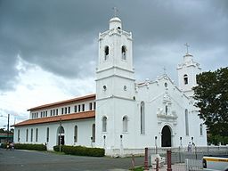 Penonomé Church, Coclé Province
 Flag
FlagCountry Panama Capital Penonomé Lowest point Sea level Area 4,946.6 km2 (1,910 sq mi) Population 233,708 (2010) Census Density 47.2 / km2 (122 / sq mi) Timezone Eastern Time (UTC-5) ISO 3166-2 code PA-1 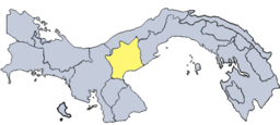 Location of Coclé in Panama
Coclé is a province of central Panama on the nation's southern coast. The capital is the city of Penonomé. This province was created by the Act of September 12, 1855 with the title of Department of Coclé during the presidency of Dr. Justo de Arosemena. It became a province, Decretory Number 190, on October 20, 1985. Coclé is primarily an agricultural area, with sugar and tomatoes as major crops. The province has a number of well known beaches, such as Santa Clara, Farallon and Rio Hato, and tourist activity has increased in recent years. It has a population of 233,708 habitants (2010).
Contents
Pre-Columbian Coclé
Main article: Pre-Columbian CocléDuring pre-Columbian times, the area of Panama which today includes Coclé province had a number of identifiable native cultures. Archaeologists have loosely designated these cultures by pottery style. The poorly studied La Mula period ranged from 150 BC to AD 300. It was followed by the Tonosi period, from AD 300 to AD 550, and by the Cubita period, from AD 550 to AD 700. A unified Native American culture appears to have flourished in this area from approximately 1200 BC until the 16th century.
Districts
The province is divided into six districts:
- Aguadulce. Corregimientos include Aguadulce (capital), El Cristo, El Roble, Pocrí and Barrios Unidos.
- Antón. Corregimientos include Antón (capital), Cabuya, El Chirú, El Retiro, El Valle, Juan Díaz, Río Hato, San Juan de Dios, Santa Rita and Caballero.
- La Pintada. Corregimientos include La Pintada (capital), El Harino, El Potrero, Llano Grande, Piedras Gordas and Las Lomas.
- Natá. Corregimientos include Natá (capital), Capellanía, El Caño, Guzmán, Las Huacas and Toza.
- Penonomé. Corregimientos include Penonomé (capital), Cañaveral, Coclé, Chiguirí Arriba, El Coco, Pajonal, Río Grande, Río Indio, Toabré and Tulú.
Research and Conservation
Coclé is host to La MICA Biological Station where ongoing field research and conservation education is conducted. Parque Nacional General de División Omar Torrijos Herrera, established around the crash site of former Panamanian leader Omar Torrijos, is located in the northeastern portion of Coclé. Parque Omar, as it is known, enjoys some legal protection as a national park.
Coclé is also home to APROVACA orchid conservation center, which conducts orchid conservation activities, including orchid reintroduction into the wild and a sponsorship program for the Panamanian national flower Peristeria elata.[1]
External links
- APROVACA Orchid Conservation Center
- Coclé Archaeological Sites
- Sito Conte On-Line Collection, University of Pennsylvania Museum
- Pre-Columbian Gold artifacts from the Cocle Province
- Pre-Columbian Jade artifacts from the Cocle Province
- Pre-Columbian Stone artifacts from Cocle
- Pre-Columbian Pottery from Cocle
- Listing of Additional Archaeological Websites
References
- Lothrop, Samuel Kirland. Pre-Columbian Designs from Panama -Illustrations of Coclé Pottery. Dover Publications, Toronto, Canada, 1976. ISBN 0-486-23232-8.
References
Capital: PenonoméAguadulce 
Antón La Pintada La Pintada · El Harino, El Potrero · Llano Grande · Piedras Gordas · Las LomasNatá Olá Penonomé Penonomé · Cañaveral · Coclé · Chiguirí Arriba · El Coco · Pajonal, Río Grande · Río Indio · Toabré · TulúProvinces Bocas del Toro · Chiriquí · Coclé · Colón · Darién · Herrera · Los Santos · Panamá · Veraguas

Comarcas indígenas
("Indigenous regions")Categories:- Provinces of Panama
- Coclé Province
- Pre-Columbian pottery
- States and territories established in 1855


Wikimedia Foundation. 2010.