- Chepigana District
-
Chepigana District — District — Location of the district capital in Panama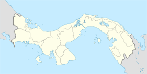
 Chepigana District
Coordinates: 8°24′36″N 78°9′0″W / 8.41°N 78.15°W Country  Panama
Province Darién Province Capital La Palma Area - Total 2,822 sq mi (7,309 km2) Population (2000) - Total 27,461 Time zone ETZ (UTC-5) Chepigana District is a district (distrito) of Darién Province in Panama. The population according to the 2000 census was 27,461.[1]The district covers a total area of 7,309 km². The capital lies at the city of La Palma.[1]
Administrative divisions
The district is divided administratively into the following corregimientos:
La Palma (capital), Camoganti, Chepigana, Garachiné, Jaqué, Puerto Piña, Río Congo, Río Iglesias, Sambú, Setegantí, Taimatí, Tucutí, Agua Fría, Cucunatí, Río Congo Arriba and Santa Fe.
References
- ^ a b "Districts of Panama". Statoids. http://www.statoids.com/ypa.html. Retrieved April 13, 2009.
Chepigana District Pinogana District El Real de Santa María · Boca de Cupe · Paya · Pinogana · Púcuro · Yape · Yaviza · Metetí · WargandiGeography Bay of San Miguel · Bayano Caves · Bayano Dam · Darién National Park · Darién Gap · Lago Bayano · Tuira River · Easternmost point of Central America
Transportation El Llano-Cartí road · Inter-American Highway
Settlements  Districts of Panama
Bocas del Toro Province Chiriquí Province Alanje District · Barú District · Boquerón District · Boquete District · Bugaba District · David District · Dolega District · Gualaca District · Remedios District · Renacimiento District · San Félix District · San Lorenzo District · Tolé DistrictCoclé Province Aguadulce District · Antón District · La Pintada District · Natá District · Olá District · Penonomé DistrictColón Province Darién Province Chepigana District · Pinogana DistrictHerrera Province Chitré District · Las Minas District · Los Pozos District · Ocú District · Parita District · Pesé District · Santa María DistrictLos Santos Province Guararé District · Las Tablas District · Los Santos District · Macaracas District · Pedasí District · Pocrí District · Tonosí DistrictPanamá Province Arraiján District · Balboa District · Capira District · Chame District · Chepo District · Chimán District · La Chorrera District · Panamá District · San Carlos District · San Miguelito District · Taboga DistrictVeraguas Province Atalaya District · Calobre District · Cañazas District · La Mesa District · Las Palmas District · Montijo District · Río de Jesús District · San Francisco District · Santa Fé District · Santiago District, Veraguas · Soná District · Mariato DistrictCategories:- Panama geography stubs
- Districts of Panama

Wikimedia Foundation. 2010.