- Cerro Kamuk
-
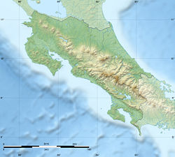
Cerro Kamuk Costa Rica Elevation 3,549 m (11,644 ft) Location Range Cordillera de Talamanca Coordinates 9°17′N 83°02′W / 9.283°N 83.033°WCoordinates: 9°17′N 83°02′W / 9.283°N 83.033°W Cerro Kamuk is a mountain in the core of the foothills and mountains of La Amistad International Park, in the Cordillera de Talamanca, between the mountain ranges of northern Panama and south-eastern Costa Rica. These are the highest and wildest mountains of Central America. The diversity of species of this area is unequaled in any other reserve of equivalent size in the world. The area protected comprises four national parks clustered together that become La Amistad Biosphere Reserve. UNESCO declared it a natural World Heritage Site since 1983 and is part of the Mesoamerican Biological Corridor UNESCO's project shared by eight Central American countries (Panama, Costa Rica, Nicaragua, El Salvador, Honduras, Belize, Guatemala and South of Mexico) to help protect the remaining pristine mountain forest and wildlife of Central America
Kamuk peak rises to 3,549 metres (11,644 ft) above sea level. It takes 4 days to reach the its top, one way, (7 days for the complete expedition). Journeys require about 6 to 10 hours hiking per day. The climb to the summit is non technical, but since the trail often gets consumed by its own wildlife, it is absolutely necessary to have a certified guide. There are no trail signs and water is found only near campsites. The absolute fragility and pristiness of this area requires that explorers take very important precautions: take only new tenting and camping equipment, free of spores, mildew or other microorganisms, as they may cause an ecological disaster. Wash your hiking boots and make sure you bring no soil from other areas of the world.
The seasonality to explore the Talamanca Range and climb Kamuk ranges from November to April only, and is closed the rest of the year due to heavy rains, tree falls, management and protection of species.
A not for profit organization Organizacion Xtremas, develops community projects to help local inhabitants, native indigenous, Bribris and Cabecar people around the Talamanca range area. This organization is always seeking for travel volunteers. Through this organization you may find also local experts, naturalist guides and more information on how to explore Talamanca and climb Kamuk.
Categories:- Mountains of Costa Rica
- Mountains of Panama
- Costa Rica geography stubs
Wikimedia Foundation. 2010.

