- Nalanda district
-
Nalanda district
नालंदा जिला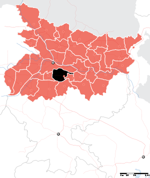
Location of Nalanda district in BiharState Bihar,  India
IndiaAdministrative division Patna Headquarters Bihar Sharif Area 2,367 km2 (914 sq mi) Population 28,72,523 (2011) Population density 1,214 /km2 (3,140 /sq mi) Literacy 66.41 (M=77.11; F=54.76) Sex ratio 921 (2011) Lok Sabha Constituencies Nalanda Major highways NH 31, NH 82, NH 110 Official website Nalanda district is one of the thirty-eight districts of Bihar state, India, and Bihar Sharif town is the administrative headquarters of this district. It is currently a part of the Red Corridor.[1]
Contents
History
Nalanda became a fully-fledged district when it was split from Patna in 1976.[2]
Geography
Nalanda district occupies an area of 2,355 square kilometres (909 sq mi),[3] comparatively equivalent to Canada's Cornwall Island.[4]
Nalanda district is a part of Patna Division.Rivers: Phalgu, Mohane,Jirayan,Kumbhari
Economy
In 2006 the Ministry of Panchayati Raj named Nalanda one of the country's 250 most backward districts (out of a total of 640).[5] It is one of the 36 districts in Bihar currently receiving funds from the Backward Regions Grant Fund Programme (BRGF).[5]
Divisions
Sub Divisions: 3 - Bihar Sharif, Rajgir, Hilsa
Blocks: 20 - Giriyak, Rahui, Noorsarai, Harnaut, Chandi (Nalanda), Islampur (Nalanda), Rajgir, Asthawan, Sarmera, Hilsa, Biharsharif, Ekangarsarai, Bena, Nagarnausa, Karai Parsarai, Silao, Parwalpur, Katrisarai, Bind, TharthariDemographics
According to the 2011 census Nalanda district has a population of 2,872,523 ,[6] roughly equal to the nation of Jamaica[7] or the US state of Kansas.[8] This gives it a ranking of 134th in India (out of a total of 640).[6] The district has a population density of 1,220 inhabitants per square kilometre (3,200 /sq mi) .[6] Its population growth rate over the decade 2001-2011 was 21.18 %.[6] Nalanda has a sex ratio of 921 females for every 1000 males,[6] and a literacy rate of 66.41 %.[6]
Flora and fauna
In 1978 Nalanda district became home to the Rajgir Wildlife Sanctuary, which has an area of 36 km2 (13.9 sq mi).[9]
References
- ^ "83 districts under the Security Related Expenditure Scheme". IntelliBriefs. 2009-12-11. http://intellibriefs.blogspot.com/2009/12/naxal-menace-83-districts-under.html. Retrieved 2011-09-17.
- ^ Law, Gwillim (2011-09-25). "Districts of India". Statoids. http://www.statoids.com/yin.html. Retrieved 2011-10-11.
- ^ Srivastava, Dayawanti et al. (ed.) (2010). "States and Union Territories: Bihar: Government". India 2010: A Reference Annual (54th ed.). New Delhi, India: Additional Director General, Publications Division, Ministry of Information and Broadcasting (India), Government of India. pp. 1118-1119. ISBN 978-81-230-1617-7.
- ^ "Island Directory Tables: Islands by Land Area". United Nations Environment Program. 1998-02-18. http://islands.unep.ch/Tiarea.htm. Retrieved 2011-10-11. "Cornwall Island 2,358km2"
- ^ a b Ministry of Panchayati Raj (September 8, 2009). "A Note on the Backward Regions Grant Fund Programme". National Institute of Rural Development. http://www.nird.org.in/brgf/doc/brgf_BackgroundNote.pdf. Retrieved September 27, 2011.
- ^ a b c d e f "District Census 2011". Census2011.co.in. 2011. http://www.census2011.co.in/district.php. Retrieved 2011-09-30.
- ^ US Directorate of Intelligence. "Country Comparison:Population". https://www.cia.gov/library/publications/the-world-factbook/rankorder/2119rank.html. Retrieved 2011-10-01. "Jamaica 2,868,380 July 2011 est"
- ^ "2010 Resident Population Data". U. S. Census Bureau. http://2010.census.gov/2010census/data/apportionment-pop-text.php. Retrieved 2011-09-30. "Kansas 2,853,118"
- ^ Indian Ministry of Forests and Environment. "Protected areas: Bihar". http://oldwww.wii.gov.in/envis/envis_pa_network/index.htm. Retrieved September 25, 2011.
External links

Patna district Lakhisarai district Jehanabad district 
Sheikhpura district  Nalanda district

Gaya district Nawada district Divisions and districts of Bihar, India Bhagalpur: Darbhanga: Kosi: Magadh: Munger: Patna: Purnia: Saran: Tirhut: Cities and towns in Patna Division Bhojpur district Buxar district Kaimur district Patna district Bakhtiarpur • Barh • Bikram • Danapur • Dinapur Cantonment • Dinapur Nizamat • Fatuha • Hasanchak • Khagaul • Khusrupur • Maner • Maner Sharif • Masaurhi • Mokameh • Nadwan • Paliganj • Patna • Phulwari SharifRohtas district Nalanda district See also Patna division topicsCities and towns
in other DivisionsPatna division topics General Azimabad • Battle of Buxar • Kaimur Range • Nalanda • Pataliputra • Takht Sri Patna Sahib • Tourism in PatnaDistricts Rivers Dams, barrages Indrapuri BarrageTransport NH 2 • NH 30 • NH 31 • NH 82 • NH 83 • NH 84 • NH 110 • Howrah-Delhi main line • Mahatma Gandhi Setu • Koilwar bridge • Nehru Setu • Jawahar Setu • Rajendra Setu • Ganga Rail-Road BridgeLok Sabha constituencies See also Other Divisions Bhagalpur • Darbhanga • Kosi • Magadh • Munger • Purnia • Saran • TirhutCategories:- Patna Division
- Districts of Bihar
- Nalanda district
- Bihar geography stubs

Wikimedia Foundation. 2010.