- Maner Sharif
-
Maner — city — Coordinates 25°39′N 84°53′E / 25.65°N 84.88°ECoordinates: 25°39′N 84°53′E / 25.65°N 84.88°E Country India State Bihar District(s) Patna Population 26,912 (2001[update]) Time zone IST (UTC+05:30) Area
• 54 metres (177 ft)
Website patna.nic.in Maner Sharif (Hindi: मनेर शरीफ़, Urdu: منیر شریف) is located 25 kilometres (16 mi) west of Patna on NH 30. It is also called Maner (Hindi: मनेर, Urdu: منیر). It is a popular medieval site and a notified area in Patna district in the Indian state of Bihar. Maner enjoys position of one of the chief spiritual centers in India. Maner Sharif houses two very popular Muslim tombs:
- One of Makhdoom Yahya Maneri, known as the Bari Dargah.
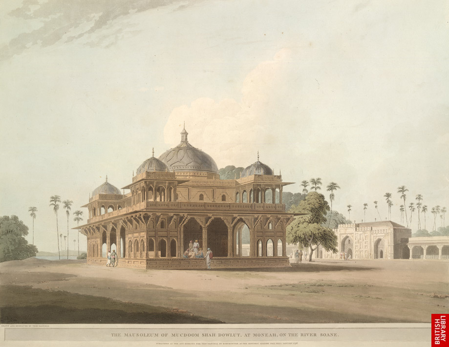
- Another of Shah Daulat or Makhdum Daulat, popularly called Chhoti Dargah.
Contents
History
Maner Sharif is the place where Makhdum Daulat in 1608 breathed his last. It was then in 1616 that Ibrahim Khan, Governor of Bihar, who was also his disciple finished the construction of his mausoleum.[1]
 Choti Dargah - 1780s painting
The building at Maner Sharif is a marvelous one. The walls of the building are adorned with intricate designs. There is a big dome on the top and the ceiling is full of inscriptions depicted from the Qur'an. In the compound of the Maner Sharif you will find a mosque which was also constructed by Ibrahim Khan in 1619.[2] In the ancient times, Maner Sharif used to be the principal site of learning and knowledge in the region. The well known grammarian Pāṇini as well as Bararuchi were the residents of Maner Sharif, where they have completed their studies as well.
Maner is also famous for its sweet delicacy laddu made with pure ghee. As the Halwai's quote - the groundwater is sweet as sugar (comes from the Sone river). When the final mixing is done with 'boondi', the groundwater acts as a catalyst - sugar to make it pure and sweet. Every 'boondi' which forms the laddu has enough sugar that melts like a fresh sweet. 'Maner ka Laddoo' is famous in India and abroad. The sweet came into limelight in one of the Bollywood movies - Khudgarz. Branding and popularity of the sweet goes to Bhojpuri comedy filmstar and owner of Maner Sweets - Late Sri Suresh Prasad Gupta (Suresh Bhai).
Demographics
As of 2001[update] India census[3], Maner had a population of 26,912. Males constitute 53% of the population and females 47%. Maner has an average literacy rate of 52%, lower than the national average of 59.5%: male literacy is 61%, and female literacy is 42%. In Maner, 19% of the population is under 6 years of age.
Politics
Srikant Nirala of RJD won the Maner seat (assembly constituency no. 192) defeating Sacchidanand Rai of JD(U) in October 2005 and February 2005. Bhai Birendra of SAP defeated Srikat Nirala of RJD in 2000. Srikant Nirala representing Janata Dal defeated Bhai Birendra (Independent) in 1995. Srikant Nirala representing Congress defeated Suryadeo Tyagi of Janata Dal in 1990. Rajmati devi representing Congress defeated Suryadeo Tyagi representing LKD in 1985. Ram Nagina Singh (Independent) defeated Suryadeo Tyagi of Janata Party (SC) in 1980. Suryadeo Tyagi representing Janata Party defeated Ram Nagina Singh representing Congress in 1977. [4]
Maner assembly constituency is part of Pataliputra (Lok Sabha constituency). [5]
187 Maner assembly constituency covers Maner community development block; and Aanandpur, Kateshar, Sikandarpur, Parev, Daulatpur Simri, Mushepur, Shri Rampur, Bihta, Dayalpur Daulatpur, Purshottampur Painathi, Bishunpura, Raghopur, Amhara, Kanchanpur Kharagpur, Sadisopur, Painal, Bela, Neora, Makhdoompur and Shri Chandpur gram panchayats of Bihta CD Block.[6]
Further reading
- Encyclopaedia of Sufism (12 volumes edited by Masood Ali Khan and S. Ram) ISBN 8126113111
References
- ^ http://discoverbihar.bih.nic.in/pages/sufi_circuit.htm
- ^ http://www.fonsvitae.com/maneri.html
- ^ "Census of India 2001: Data from the 2001 Census, including cities, villages and towns (Provisional)". Census Commission of India. Archived from the original on 2004-06-16. http://web.archive.org/web/20040616075334/http://www.censusindia.net/results/town.php?stad=A&state5=999. Retrieved 2008-11-01.
- ^ "192 - Maner Assembly Constituency". Partywise Comparison Since 1977. Election Commission of India. http://eci.nic.in/electionanalysis/AE/S04/partycomp192.htm. Retrieved 2009-06-05.[dead link]
- ^ "General Election 2009 Assembly constituencies". Pataliputra. India elections.co.in. http://www.indiastudychannel.com/india/loksabha/635-Pataliputra.aspx. Retrieved 2009-05-20.
- ^ "Order No. 48, 2007". Delimitation Commission of India. http://eci.nic.in/delim/Draft/Bihar/Order%20&%20Notification_English_.pdf. Retrieved 2010-05-04.
External links
Cities and towns in Patna Division Bhojpur district Buxar district Kaimur district Patna district Bakhtiarpur • Barh • Bikram • Danapur • Dinapur Cantonment • Dinapur Nizamat • Fatuha • Hasanchak • Khagaul • Khusrupur • Maner • Maner Sharif • Masaurhi • Mokameh • Nadwan • Paliganj • Patna • Phulwari SharifRohtas district Nalanda district See also Patna division topicsCities and towns
in other DivisionsCategories:- Indian Sufis
- Patna
- Visitor attractions in Patna
- Indian religious biography stubs
- Islamic biography stubs


Wikimedia Foundation. 2010.