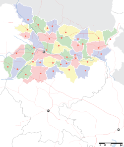
- Mokama
-
Mokameh
Mokama
— city — Coordinates 25°23′23.28″N 85°55′08.75″E / 25.3898°N 85.9190972°ECoordinates: 25°23′23.28″N 85°55′08.75″E / 25.3898°N 85.9190972°E Country India Region Magadh State Bihar District(s) Patna Parliamentary constituency Munger Assembly constituency Mokameh(183) Population 96,441 (2001[update]) Sex ratio 1000/892 ♂/♀ Literacy
• Male
• Female96.00%
• 99.00%
• 93.00%Official languages Hindi, Magadhi, English Time zone IST (UTC+05:30) Area
• 38 metres (125 ft)
Climate
ETh (Köppen)
• 1,000 mm (39 in)
Website patna.nic.in Mokama (Hindi: मोकामा) is a city and a municipality in Patna district in the Indian state of Bihar. It is located 90 KM east of Patna and is on the rail route connecting Kolkata and New Delhi via Patna. It is said that Mokama (मोकामा) was on the route of the armies moving along the river Ganga during the Mughal or British periods. It was their place of resting or Mukam (मुकाम) which means destination in Hindustani. So the name Mokama came into being over the years.
Contents
Geography
Mokama is situated on the southern banks of the Ganges. The landscape here is absolutely plain. Here the land strip along the north of Ganges is called Diara which submerges in Ganges during monsoons, On the south of Mokameh is the "Tal" region which also gets submerged with the backwaters of the Ganges during the monsoons.
Localities
Some of the important localities in Mokama municipality are Sakarwar Tola, Moldiar Tola, Kowabhonk and Chintamanchak.
Economy
Not surprisingly, the main occupation is agriculture. Traveling through the city, one can hardly see anything, other than crop fields. Main crops are, Lentils, Chickpea, mustard and vegetables. Papaya is also grown here. However, major portion of the Diara and Tal lands remain submerged for 3 months, giving an impression of sea. Mokameh, once was developing as a market and a trading place. But it has suffered because of rise of local criminals and huge haftas demanded by them. Mokama boasts of factories of McDowell's and Bata Shoes, along with Bharat Wagon and Engineering.
Transport
Mokama is connected to all the major cities of India by rail and road. Maokama is the junction point of NH 82 and NH 31. Rajendra Setu located near Mokama connects it to North Bihar. However the neighbouring areas lacked any kind of road until recently. Due to the present condition of the roads the largest and the best mode of transport in Mokameh is rail.
Demographics
As of 2010[update] India census[1], Mokama had a population of 96,441. Males constitute 53% of the population and females 47%. Mokama has a literacy rate of 96%, higher than the national average of 69.5%: male literacy is 99%, and female literacy is 93%. In Mokama, 16% of the population is under 6 years of age.AUNTA is the most developed village of MOKAMA block. This is only village in mokama which is known as ADARSH GRAM. There are so many industries in Aunta. There is a CRPF training centre at Mokamaghat.
People and Culture
Most people speak Magadhi here, a dialect called Magahi locally. However, it changes considerably across a couple of Kilometres. Families are very traditional, and often large. However, as people are getting education, they are becoming liberal. Marriages are generally arranged and they involve a large sum of dowry, although illegal. Bride and groom meet only after marriage. Caste system is ingrained in the social fabric of the place in the same way as it exists in other parts of Bihar. Consequently caste based politics plays an important role in the life of the people here. The continuously diminishing infrastructure and unemployment have forced the people to migrate to other parts of India for better opportunities. The common attire of the people includes dhoti, kurta and gamchha, a large rectangular cotton cloth on their shoulders or tied round heads. Women dress in sarees. The most awaited and widely celebrated festival is Chhath, a festival where people worship the setting and the rising Sun in the month of October/November. About 1.5 km west form mokama station lies a famous pilgrim place named Baba Parsuram Mandir. Sherpur village is a very peaceful & well educated place in Mokama block.
News from Mokama
References
- ^ "Census of India 2001: Data from the 2001 Census, including cities, villages and towns (Provisional)". Census Commission of India. Archived from the original on 2004-06-16. http://web.archive.org/web/20040616075334/http://www.censusindia.net/results/town.php?stad=A&state5=999. Retrieved 2008-11-01.
Cities and towns in Patna Division Bhojpur district Buxar district Kaimur district Patna district Bakhtiarpur • Barh • Bikram • Danapur • Dinapur Cantonment • Dinapur Nizamat • Fatuha • Hasanchak • Khagaul • Khusrupur • Maner • Maner Sharif • Masaurhi • Mokameh • Nadwan • Paliganj • Patna • Phulwari SharifRohtas district Nalanda district See also Patna division topicsCities and towns
in other DivisionsCategories:- Cities and towns in Patna district
Wikimedia Foundation. 2010.


