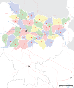
- Nadwan, Patna
-
Nadwan — village — Coordinates 25°24′00″N 85°04′00″E / 25.4°N 85.0666667°ECoordinates: 25°24′00″N 85°04′00″E / 25.4°N 85.0666667°E Country India State Bihar District(s) Patna Population 10,000 Time zone IST (UTC+05:30) Footnotes- By- Nand Kumar Ajad
Website patna.nic.in Nadwan (Hindi: नदवाँ, Urdu: نادوان), a village in Patna district in Bihar in India, is located about 24 km south from Patna and 70 km north from Gaya, the place where Gautum Buddha got enlightenment. Patna's ancient names are Pataliputra and Kusumpur and it was the capital of the great Magadh empire for a very long period of time. It is established on NH-73, and has a very old Railway station(1n 1934) on Patna - Gaya railway route. this railway station is main focus of attraction for nearby 30-35 villages.
The village Nadwan was once considered one of the most respected village in the Patna district. However, due to the rise of anti-social activities (between 1998-2002), this village has lost its past glory. But now its glory is coming on track.
Education
Around 60 years ago, villagers of Nadwan opened a school (now known as Middle School and High School Nadwan). This school has produced many doctors, engineers, and scientists. This village also has a college, K P S College Nadwan (http://kpscollege.org/) This is the main source of poor villagers for doing his/her graduation and Post Graduation. Recently, so many educational institutions move toward this Village, and now a very reputed public school- Doon Public School (http://dphspatna.com) Opened his branch. Due to Doon Public School village's children can get good schooling from his native village in English medium. And soon some college and some more schools will open here.
References
Template:Reflist: Nand Kumar Ajad
Cities and towns in Patna Division Bhojpur district Buxar district Kaimur district Patna district Bakhtiarpur • Barh • Bikram • Danapur • Dinapur Cantonment • Dinapur Nizamat • Fatuha • Hasanchak • Khagaul • Khusrupur • Maner • Maner Sharif • Masaurhi • Mokameh • Nadwan • Paliganj • Patna • Phulwari SharifRohtas district Nalanda district See also Patna division topicsCities and towns
in other DivisionsCategories:- Patna
- Villages in Patna district
- Bihar geography stubs
Wikimedia Foundation. 2010.


