- 2011 Mississippi River floods
-
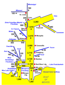
The Great 2011 Mississippi River floods 100 populated locations were experiencing major or moderate flooding on May 8, 2011.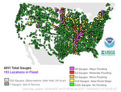
Source: National Weather ServiceDuration: May 4, 2011 to present Fatalities: About 20, beyond 383 in preceding storms [1][not in citation given] Damages: US$2 to 4 billion[1][2] Areas affected: Mississippi River Valley, United States The Mississippi River floods in April and May 2011 were among the largest and most damaging recorded along the U.S. waterway in the past century, comparable in extent to the major floods of 1927 and 1993. In April 2011, two major storm systems deposited record levels of rainfall on the Mississippi River watershed. When that additional water combined with the springtime snowmelt, the river and many of its tributaries began to swell to record levels by the beginning of May. Areas along the Mississippi itself experiencing flooding include Illinois, Missouri, Kentucky, Tennessee, Arkansas, Mississippi, and Louisiana. U.S. President Barack Obama declared the western counties of Kentucky, Tennessee, and Mississippi federal disaster areas.[3] For the first time in 37 years, the Morganza Spillway was opened on May 14, deliberately flooding 4,600 square miles (12,000 km2) of rural Louisiana to save most of Baton Rouge and New Orleans.[4]
Fourteen people were killed in Arkansas,[5] with at least 383 killed across seven states in the preceding storms.[6][not in citation given] Thousands of homes were ordered evacuated, including over 1,300 in Memphis, Tennessee,[7] and more than 24,500 in Louisiana and Mississippi state.[8][9] Some people are disregarding mandatory evacuation orders.[10] Up to 13% of U.S. petroleum refinery output is expected to be disrupted by flood levels exceeding historical records in several locations,[11] with gasoline prices expected to rise.[12] The flood crested in Memphis on May 10 and artificially crested in southern Louisiana on May 15, a week earlier than it would have if spillways had not been opened.[13] The Army Corps of Engineers stated that an area in Louisiana between Simmesport and Baton Rouge is expected to be inundated with 20–30 feet (6.1–9.1 m) of water.[14][15] Baton Rouge, New Orleans, and many other river towns are threatened,[16][17] but officials stress that they should be able to avoid catastrophic flooding.[18]
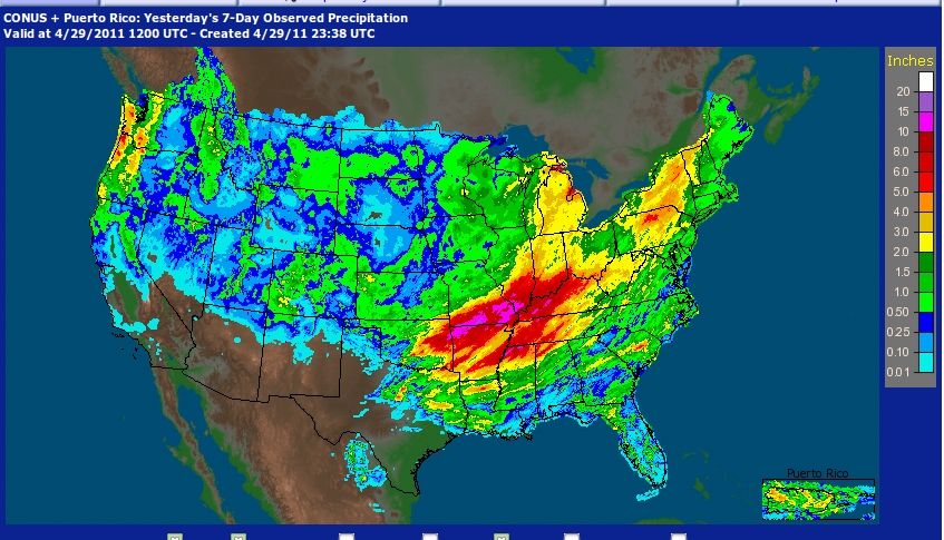
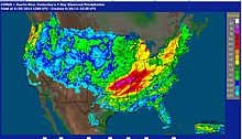 Rainfall totals within the United States for the week ending April 29.
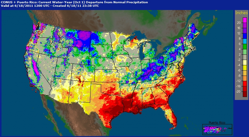
 U.S. Weather Service map showing number of inches of precipitation above/below normal year to date at June 18, 2011. The map shows that significantly large amounts of precipitation in the Ohio River basin that resulted in the worst of the flooding being below confluence of the Ohio and Mississippi. Ironically, Louisiana which experienced the worst of the flood was actually in a major drought. Heavy precipitation in the head waters of the Missouri River in Montana resulted in the 2011 Missouri River Floods which is expected to begin affecting the Mississippi in late June (although to a lesser degree than than the April flood). Significantly lower than normal rain in eastern Arizona led to the Wallow Fire in May/June.
From April 14–16, the storm system responsible for one of the largest tornado outbreaks in U.S. history also produced large amounts of rainfall across the southern and midwestern United States. Two more storm systems, each with heavy rain and tornadoes, hit in the third week of April. In the fourth week of April, from April 25–28, another, even more extensive and deadly storm system passed through the Mississippi Valley dumping more rainfall resulting in deadly flash floods. This latter storm produced over 250 tornadoes, the deadliest tornado outbreak since 1925, causing an estimated $5 billion dollars in damage. The unprecedented extensive rainfall from these four storms, combined with springtime snow melt from the Upper Midwest, created the perfect situation for a 500-year flood along the Mississippi.
Contents
Flood stages and effects by state
As flood waters have proceeded down the Lower Mississippi from the St. Louis area (where the Missouri River and the Mississippi River converge), they have affected Missouri and Illinois, then Tennessee, Arkansas, Mississippi, and Louisiana.
Missouri and Illinois
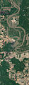
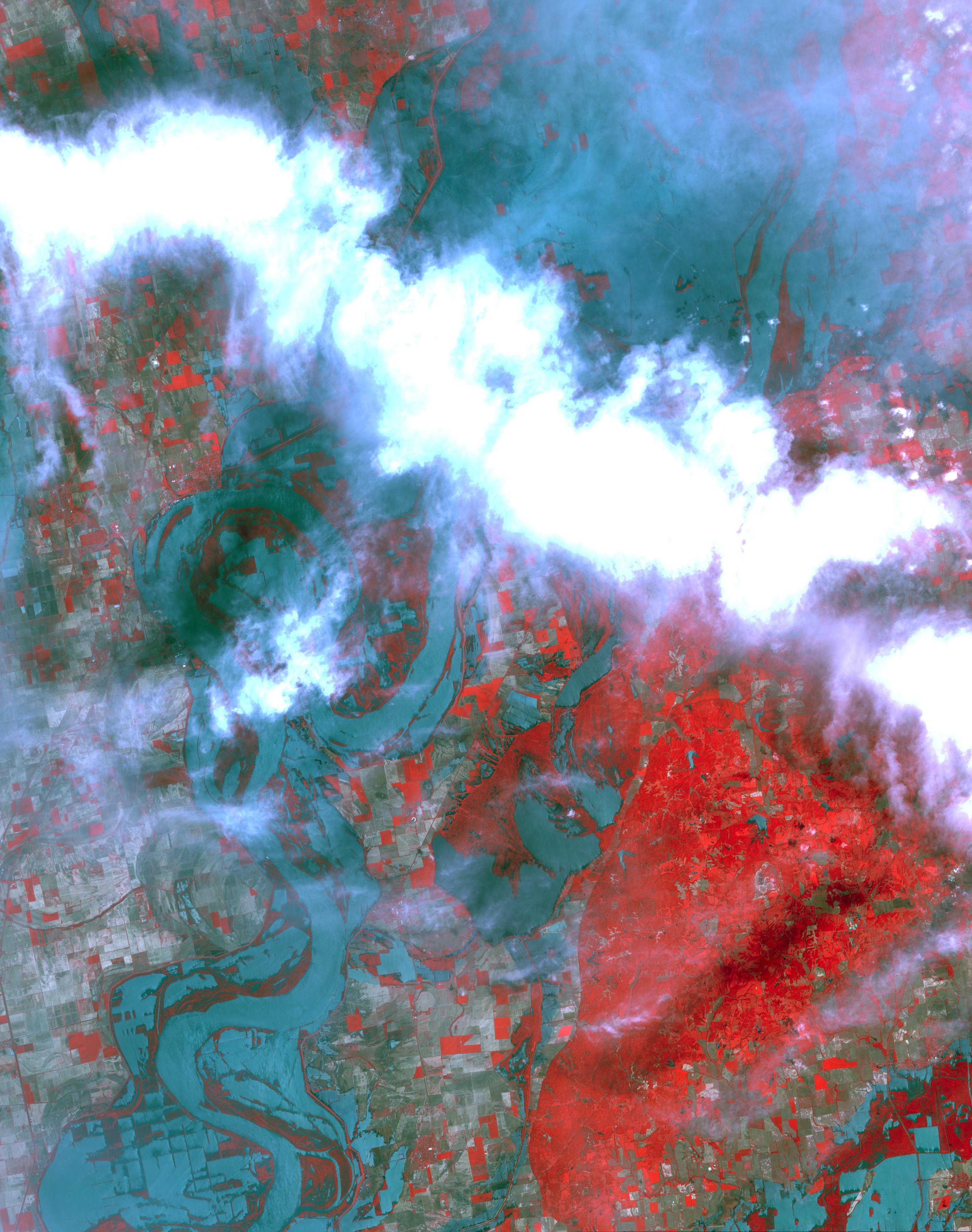
 This image shows the resultant flooding of farmland west of the Mississippi 32 kilometres south of the deliberate levee breach near Cairo, Illinois.
On May 3, the Army Corps of Engineers blasted a two-mile (3 km) hole in the levee protecting the Birds Point-New Madrid Floodway, flooding 130,000 acres (530 km2) of farmland in Mississippi County, Missouri, in an effort to save the town of Cairo, Illinois and the rest of the levee system, from record-breaking flood waters.[19] The breach displaced around 200 residents of Missouri's Mississippi and New Madrid counties, who were forced to evacuate after a court approved the Corps of Engineers plan to breach the levee.[20]
Tennessee
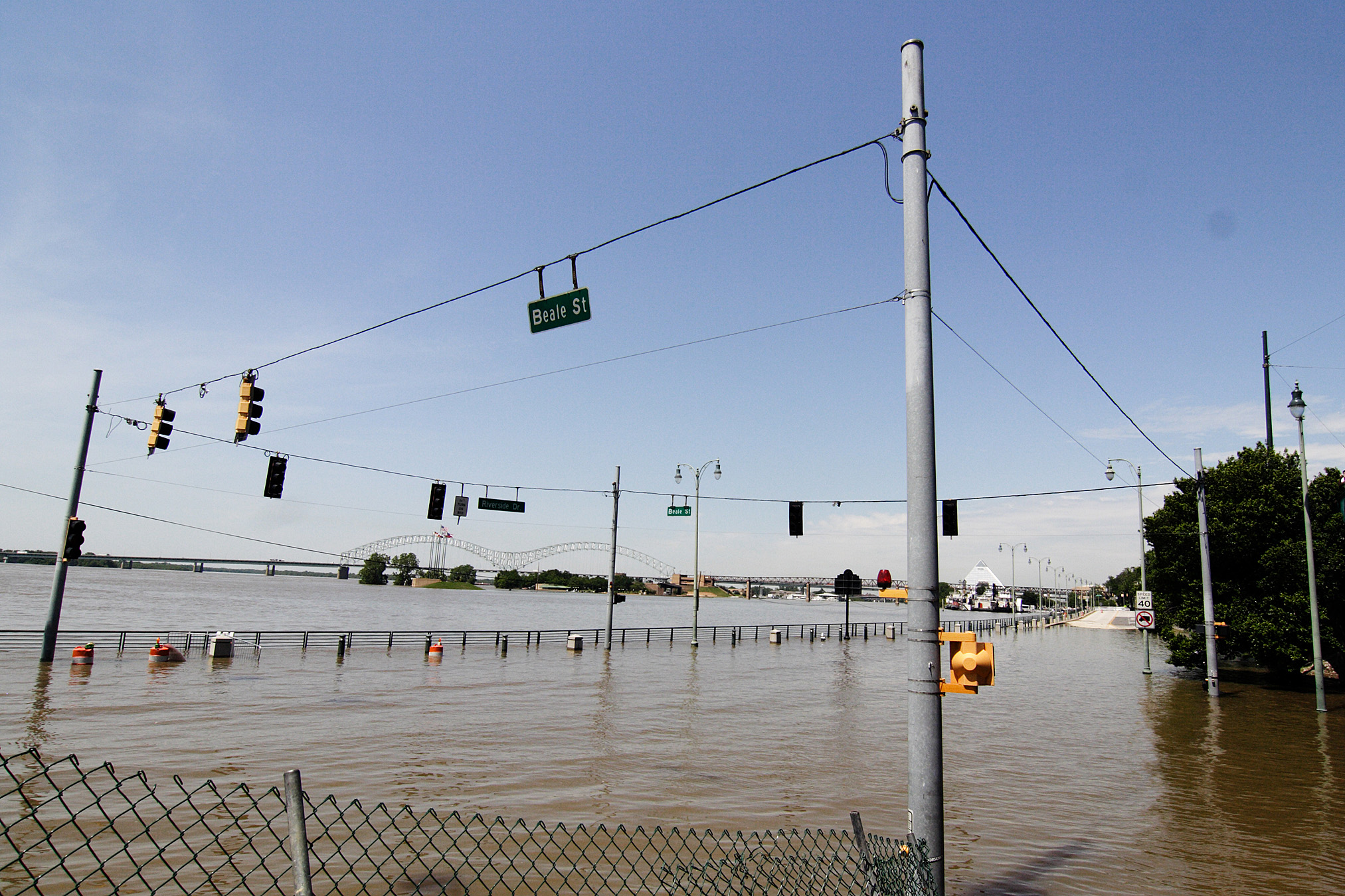
Dyersburg, a city in northwestern Tennessee, experienced the worst flooding with over 600 homes and businesses inundated as the Forked Deer River, a tributary of the Mississippi, flowed backwards into southern areas of the city.[21] In Memphis, Tennessee, the up-scale neighborhood of Harbor Town, located along the river on Mud Island in Downtown Memphis, evacuated its 5,200 residents as flood waters rose to record levels.[22] On May 10, the river reached 47.8 feet (14.6 m), the highest level reached at Memphis since 1937, when the river there reached a record 48.7 feet (14.8 m), and the second highest level ever recorded, even surpassing the 1927 flood. Many local rivers spilled their banks, including Big Creek, the Loosahatchie River, and the Wolf River along with Nonconnah Creek. Subsequent flooding occurred in Millington, as well as suburban areas of Frayser, Bartlett, and East Memphis.
Arkansas
Interstate 40, connecting Memphis and Little Rock, experienced flooding west of Memphis along the White River between Hazen and Brinkley, where lanes in both directions were closed. Brinkley itself also experienced flooding. Eight people died in Arkansas as a result of flooding.[23]
Mississippi
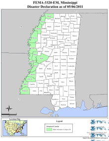 Mississippi counties declared federal disaster areas.
In Tunica County, nine casinos located on stationary river barges were closed. The hotel portion of the casinos are located on adjacent, low-lying land, and began to flood with the rising waters. On May 5, the Harrah's Tunica has reported nearly 6 feet (1.8 m) of water inside the ground floor of the hotel tower.[24] As of May 26, however, all 9 Tunica casinos reopened. Near Vicksburg, Highway 465 in Warren and Issaquena counties was closed on May 5 due to high flood waters.[25] U.S. Highway 61 between Vicksburg and Port Gibson was closed by backwater flooding along the Big Black River on May 12 and is tentatively scheduled to reopen on June 4. Another portion of U.S. Highway 61 near Redwood was closed by backwater flooding along the Yazoo River on May 13 and is tentatively scheduled to reopen by June 2.[26] These closures eliminated north-south highway access into Vicksburg.
In anticipation of major flooding, the U.S. federal government declared eleven counties along the Mississippi River federal disaster areas on May 5, and four more by May 7. The thirteen counties listed were Adams, Bolivar, Claiborne, Coahoma, Desoto, Issaquena, Jefferson, Sharkey, Tunica, Warren, Washington, Wilkinson, and Yazoo.[27][28] Mississippi Governor Haley Barbour urged holdouts to head for higher ground, saying "The biggest danger is that they choose not to evacuate assuming there'll be someone to rescue them," noting that emergency teams could be endangered as well. "More than anything else, save your life and don't put at risk other people who might have to come in and save your lives."[29]
The Flood of 2011 set new record stages at Vicksburg and Natchez and approached record levels at Greenville and Memphis.[30] Provisional estimates by the USGS indicate that the peak streamflow at Vicksburg, 2,340,000 cubic feet per second (66,000 m3/s), exceeded the both the estimated peak streamflow of the Great Mississippi Flood of 1927, 2,278,000 cu ft/s (64,500 m3/s), and the measured peak streamflow of the 1937 flood, 2,080,000 cu ft/s (59,000 m3/s).[31][32]
Comparison of Observed 2011 Peak Stages and Record Stages[33] Gage Flood Stage (ft) Crest Stage (ft) Crest Date Prior Record Stage (ft) Prior Record Date Memphis 34 47.8 10 May 2011 48.7 10 Feb 1937 Helena 44 56.5 12 May 2011 60.2 12 Feb 1937 Arkansas City 37 53.1 16 May 2011 59.2 21 Apr 1927 Greenville 48 64.2 16 May 2011 65.4 21 Apr 1927 Vicksburg 43 57.1 19 May 2011 56.2 4 May 1927 Natchez 48 61.9 19 May 2011 58.0 21 Feb 1937 Louisiana
 Flow capacity for the Mississippi river in thousands of cubic feet per second based on the current project design flood.[34]
Following the Great Mississippi Flood of 1927, much effort has been invested in building defenses to withstand a flood of three million cubic feet per second just upstream from the Old River Control Structure. The US Army Corps of Engineers refers to this design goal as Project Flood.[34] the expected flow will be on the high side, but still within that maximum capacity, assuming everything works as expected.[35]
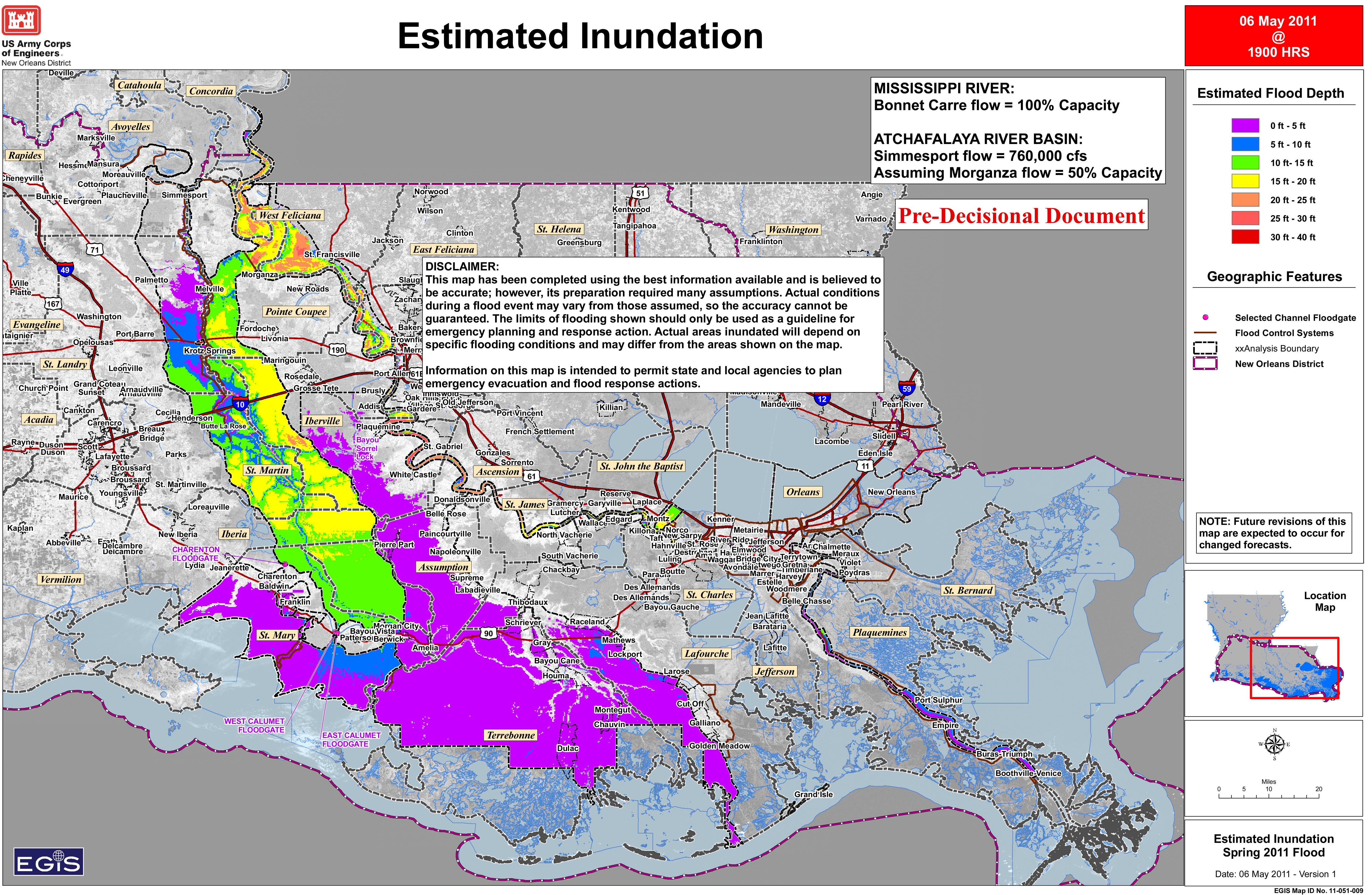
Morganza Spillway and Atchafalaya Basin
On May 14, 2011, a single floodgate of the Morganza Spillway was opened. Diversion of 125,000 cubic feet per second (3,500 m3/s) of water from the Mississippi River to the Atchafalaya Basin is planned there, with the structure operating at about 21% of its capacity. This diversion was deemed necessary to protect levees and prevent major flooding in Baton Rouge and New Orleans, with the tradeoff of exacerbating flooding in the Atchafalaya Basin, and will also reduce floodwater stress on the Old River Control Structure upstream. This was the first opening of the spillway since a 1973 flood.[4][36][37][38] See Army Engineers Open Morganza Spillway for a video of the opening of the first gate, and Morganza Spillway Fish Jumping through Gates for a video of the diversion, as seen from the highway over the spillway.
By May 15, 2011, a total of nine gates had been opened by the Corps of Engineers. The Corps has estimated that it will take opening one-fourth of the spillway’s 125 bays — or 31 bays — to control the flow of the river through Baton Rouge in response to a forecast crest of 45 feet (14 m) anticipated on Tuesday, May 17, 2011, which must remain below 1,500,000 cu ft/s (42,000 m3/s) of water per second through Baton Rouge to ensure the integrity of the levee system.[39]
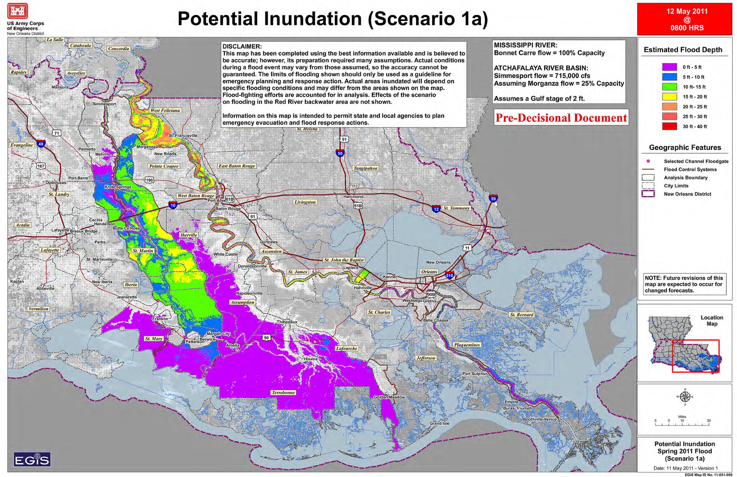
Prior to this decision, the Corps studied four flooding scenarios, all of which assumed the Bonnet Carré Spillway near New Orleans would be concurrently operating at full capacity (100%).
- Scenario 1: Open the Morganza Spillway to half (50%) of its maximum capacity, which would divert 300,000 cubic feet per second (8,500 m3/s) of water.
- Scenario 1a: Open the Morganza Spillway to one-quarter (25%) of its maximum capacity, which would divert 150,000 cubic feet per second (4,200 m3/s) of water.
- Scenario 2: Do not open the Morganza Spillway, and keep the Old River Control Structure at its routine operating level of only 30% of the Mississippi's flow; no additional water would be diverted
- Scenario 3: Do not open the Morganza Spillway, and open the Old River Control Structure somewhat more, which would divert an extra 150,000 cubic feet per second (4,200 m3/s) of water.
Following this analysis, which showed that extensive flooding is expected in the Atchafalaya Basin regardless of the choice made regarding the Morganza Spillway, the Corps decided to start the 2011 diversion by opening the spillway a bit less than described in scenario 1a (21%, not 25%)[36]
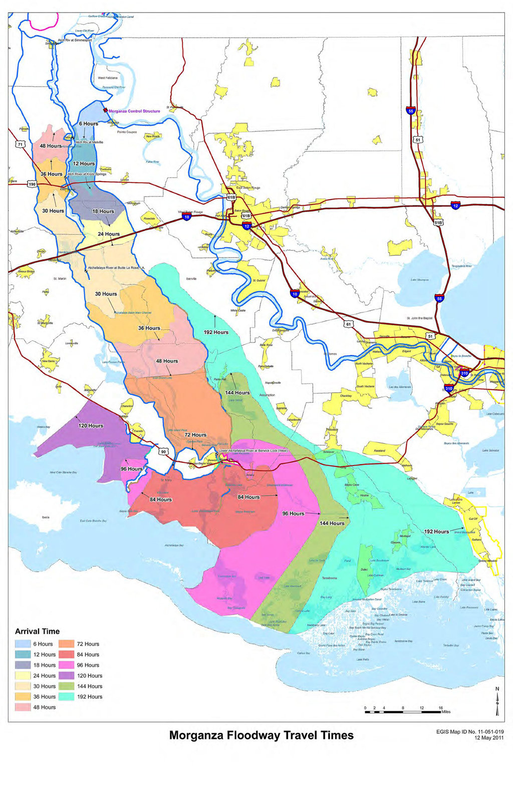
The Army Corps of Engineers subsequently released a map showing the estimated times it will take the flood waters to reach the various communities in the Atchafalaya Basin over eight days.[40]
- United States Army Corps of Engineers 2011 Louisiana Flooding Scenarios
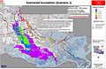
-
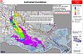
Anticipated inundation from Scenario 1
-
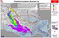
Anticipated inundation from Scenario 1a
-
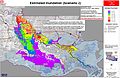
Anticipated inundation from Scenario 2
-
Anticipated inundation from Scenario 3
- Source
- United States Army Corps of Engineers[41]
-
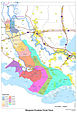
Atchafalaya Basin floodwater travel times from the Morganza Spillway.
-
Natural-colour satellite image of the Floodway on May 15, 2011.
-

False colour satellite image of the Floodway on May 15, 2011.
Baton Rouge
The Corps of Engineers intends to keep the Baton Rouge river levels at 45 feet (14 m) or below, which is three feet below the state capital's primary levees but five feet above the "major" flood stage. Shipping, industrial, and agricultural interests along the waterfront and further beyond the West side of the river are significantly impacted, and unprotected low lying areas are flooded. Opening of the spillways has caused an early artificial crest, and additional spillway floodgates will be opened as needed to limit the river level.[42]
Waterford Nuclear Generating Station
The Waterford Nuclear Generating Station, about 25 miles (40 km) west of New Orleans, was restarted May 12,[43][44] after a refueling shutdown on April 6.[45] If the river exceeds 27 feet (8.2 m) upstream the plant would be forced to shut down because a circulating water system that drives the turbine would not be able to operate.[46]
Bonnet Carré Spillway and Lake Pontchartrain
The Bonnet Carré Spillway, near New Orleans, was built to divert water from the Mississippi River to Lake Pontchartrain, and from there to the Gulf of Mexico, reducing water levels and flow near New Orleans. On May 23, 2011, 330 of this structure's 350 bays were opened due to rising water levels otherwise anticipated to jeopardize levees protecting New Orleans.[47] The Army Corps of Engineers began closing the spillway gates on June 12 as the river level began to fall and the last of the gates were closed on June 20.[48]
New Orleans
Open spillways are holding the river level at New Orleans, Louisiana, around the 17-foot (5.2 m) beginning of the flood stage, which is three feet below the levees that protect the city. Navigation and docking are difficult, but refinery and other industrial operations are continuing. However, production will be impacted by the inundation of 589 oil and gas wells in the Atchafalaya Basin producing 19,300 barrels of oil and 252.6 million cubic feet of gas per day.[49]
Risk of major course change in the Lower Mississippi River
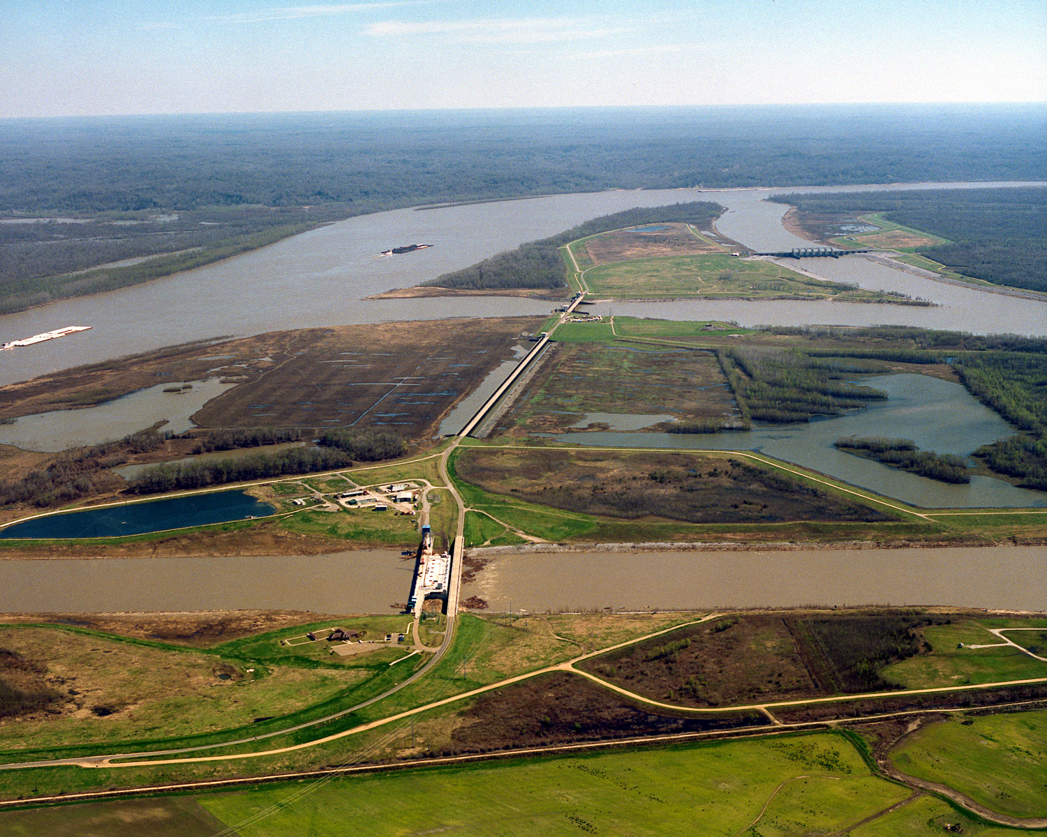
 The Old River Control Structure complex. View is to the east-southeast, looking downriver on the Mississippi, with the three dams across channels of the Atchafalaya River to the right of the Mississippi. Concordia Parish, Louisiana is in the foreground, on the right, and Wilkinson County, Mississippi, is in the background, across the Mississippi on the left.
During the 2011 floods, concerns were raised that the Mississippi might divert its main channel into the Atchafalaya Basin if the Old River Control Structure, the Morganza Spillway, or nearby levees failed, or into Lake Pontchartrain if the Bonnet Carré Spillway or adjacent levees failed.[50][51][52][53][54] Jeff Masters of the Weather Underground noted that failure of the Old River Control Structure "would be a serious blow to the U.S. economy, and the great Mississippi flood of 2011 will give [this structure] its most severe test ever."[55] See "Mississippi River: Future course changes" for further discussion.
During the 2011 floods, the Army Corps of Engineers decided to open the Morganza Spillway at 1/4 of its capacity to allow 150,000 cu ft/s (4,200 m3/s) flood the Morganza and Atchafalaya floodways.[14] In addition to reducing the 2011 flood crest downstream, this reduced the chances of a channel change by reducing stress on the other elements of the control system. As of June 2011, there have not been any official reports of on-the-ground observations regarding weakening or design flaws in any of the flood control systems designed to prevent a course change,[dated info] and the[dated info] 2011 flood flow approached but did not exceed the maximum design capacity of the flood-control system.[35] Accordingly, the Mississippi is expected to remain in its present channel as the flood waters recede.
See also
- 2011 Assiniboine River Flood
- 2011 Red River Flood
- 2011 Souris River flood
- April 25–28, 2011 tornado outbreak
- Atchafalaya River
- Bird's Point, Missouri
- Great Mississippi and Missouri Rivers Flood of 1993
- Great Mississippi Flood of 1927
- Ohio River flood of 1937
- Old River Control Structure
References
- ^ Masters, Jeffrey. "Mississippi River flood of 2011 already a $2 billion disaster". Weather Underground. Jeff Masters' WunderBlog. http://www.wunderground.com/blog/JeffMasters/comment.html?entrynum=1800. Retrieved 12 May 2011.
- ^ Strauss, Gary; Marisol Bello (May 11, 2011). "Mississippi flood damages could reach billions". Tucson Citizen. http://tucsoncitizen.com/usa-today-news/2011/05/11/mississippi-flood-damages-could-reach-billions/. Retrieved 12 May 2011.
- ^ "Obama Signs Tennessee Disaster Declaration". Blog.memphisdailynews.com. 2011-05-09. http://blog.memphisdailynews.com/?p=2209. Retrieved 2011-05-16.
- ^ a b "Rural Louisiana flooded to save New Orleans" (CBS News/Associated Press) May 14, 2011
- ^ "River floods 100 homes; state’s death toll at 14". Arkansasonline.com. 2011-04-30. http://www.arkansasonline.com/news/2011/apr/30/river-floods-100-homes-states-death-toll--20110430/. Retrieved 2011-05-16.
- ^ "Mississippi River could crest Monday at Memphis - Natural Disasters | Latest World Natural Disasters". Salon.com. 2011-05-09. http://www.salon.com/news/feature/2011/05/09/us_mississippi_river_flooding. Retrieved 2011-05-16.
- ^ "BBC News - Mississippi flood: Southern states brace for crest". Bbc.co.uk. 2011-05-11. http://www.bbc.co.uk/news/world-us-canada-13364606. Retrieved 2011-05-16.
- ^ "Gov Jindal: Morganza Spillway opening by Saturday". Times Union. 2011-05-12. http://www.timesunion.com/news/article/Gov-Jindal-Morganza-Spillway-opening-by-Saturday-1378440.php. Retrieved 2011-05-16.
- ^ "Flooding begins to 'wrap arms' around Memphis" May 7, 2011 (Toronto Sun)
- ^ Paul Rioux (May 16, 2011) "Many in way of diverted Mississippi River floodwaters ignore evacuation order" The Times-Picayune
- ^ "Mississippi at Memphis Near Record, Spurs Evacuations" May 7, 2011 (Bloomberg)
- ^ Post a Job (2011-05-10). "Mississippi Flooding Threatens Crops, Refineries and Homes". Businessweek. http://www.businessweek.com/news/2011-05-10/mississippi-flooding-threatens-crops-refineries-and-homes.html. Retrieved 2011-05-16.
- ^ "Memphis and Baton Rouge brace for record-breaking Mississippi flood". CSMonitor.com. 2011-05-08. http://www.csmonitor.com/USA/2011/0508/Memphis-and-Baton-Rouge-brace-for-record-breaking-Mississippi-flood. Retrieved 2011-05-16.
- ^ a b Estimated Inundation (US Army Corps of Engineers)
- ^ "Michael Bay's Scenario". Blog.xkcd.com. 2011-05-08. http://blog.xkcd.com/2011/05/08/michael-bays-scenario/. Retrieved 2011-05-16.
- ^ "Mississippi River rise has River Parishes residents worried" NOLA.com May 12, 2011
- ^ "'Sacrificial' towns prepare for deliberate flooding" MSNBC May 12, 2011
- ^ "Officials try to calm fears of New Orleans flooding from Mississippi River" WWL TV May 12, 2011
- ^ "Levee breach lowers river, but record flooding still forecast". CNN. May 3, 2011. http://www.cnn.com/2011/US/05/03/missouri.levee.breach/index.html?hpt=Sbin. Retrieved 2011-05-03.
- ^ "Court approves breaching of Birds Point levee". KSDK Cairo, Ill.. http://www.ksdk.com/rss/article/257042/3/Court-approves-breaching-of-Birds-Point-Levee.
- ^ "Hundreds of Structures Underwater in Dyersburg". WREG Memphis.
- ^ "Mud Island residents watch as river rises". WMC. 2011-05-05. http://www.wmctv.com/story/14567162/mud-island-residents-watch-as-river-rises. Retrieved 2011-05-05.
- ^ "Man drowned in floodwaters in eastern Arkansas". Associated Press. May 5, 2011.
- ^ "Rising waters flood Tunica casinos". WMC. 2011-05-05. http://www.wmctv.com/story/14582894/rising-waters-flood-tunica-casinos. Retrieved 2011-05-05.
- ^ "Mississippi Floods 2011: Highway 465 to Close Tonight at 7:00 p.m". My601.com. 2011-05-03. http://www.my601.com/news/local/story/Mississippi-Floods-2011-Highway-465-to-Close/qUeBdD_N_kyBofId9r4zkw.cspx. Retrieved 2011-05-16.
- ^ Hitchins, Pamela (May 30, 2011). "Last barricade moved from N. Washington". The Vicksburg Post.
- ^ "Federal Disaster Declaration Granted for Several Counties Along Mississippi River". Governorbarbour.com. 2011-05-05. http://www.governorbarbour.com/news/2011/may/5.5.barbouronfloodcountiesdeclaration.html. Retrieved 2011-05-16.
- ^ "Mississippi Flooding, Emergency Declared (EM-3320)". Fema.gov. https://www.fema.gov/news/eventcounties.fema?id=14334. Retrieved 2011-05-16.
- ^ The Associated Press. "Mississippi River flooding prompts Gov. Haley Barbour to urge Delta evacuations". NOLA.com. http://www.nola.com/environment/index.ssf/2011/05/mississippi_river_flooding_pro.html. Retrieved 2011-05-16.
- ^ U.S. National Weather Service. "Crest Summary Map along the Lower Mississippi River and Backwater Locations". http://www.srh.noaa.gov/images/jan/Weather_Events/2011/May_MS_River_Flood/Crest_Summary.png. Retrieved 29 May 2011.
- ^ WaterWatch. "WaterWatch: Water Resources Conditions, Peak, Discharge". USGS. http://waterwatch.usgs.gov/new/index.php?r=ms&id=pa01d. Retrieved 1 June 2011.
- ^ Peak Streamflow. "Peak Streamflow for the Nation USGS 07289000 MISSISSIPPI RIVER AT VICKSBURG, MS". USGS. http://nwis.waterdata.usgs.gov/nwis/peak?site_no=07289000&agency_cd=USGS&format=html. Retrieved 1 June 2011.
- ^ U.S National Weather Service. [=144108&pt[]=141463&pt[]=141839&pt[]=143934&pt[]=141618&pt[]=146423&pt[]=143366&pt[]=142172&pt[]=141493&pt[]=142940&pt[]=144619&pt[]=144798&pt[]=144609&pt[]=141308&pt[]=144449&pt[]=143828&pt[]=142711&allpoints=143846,142736,143816,143998,145144,142659,142234,145887,144081,142375,143866,141506,142962,143885,143323,144201,144542,142873,143260,143099,142560,144186,143177,142054,143945,144055,141370,143630,141931,142812,141676,142534,144568,143535,144589,143030,144031,143079,144282,141445,141722,141383,143445,143646,143787,143574,143545,142773,141629,144517,142500,143196,142105,142509,142418,144108,141463,141839,143934,141618,146423,143366,142172,141493,142940,144619,144798,144609,141308,144449,143828,142711&data[]=hydrograph&submit=Make+my+River+Page! "Mississippi River Hydrographs"]. http://water.weather.gov/ahps2/river.php?wfo=pah&wfoid=18785&riverid=203833&view=1,1,1,1,1,1,1,1&toggles=10,7,8,2,9,15,6&pt[]=144108&pt[]=141463&pt[]=141839&pt[]=143934&pt[]=141618&pt[]=146423&pt[]=143366&pt[]=142172&pt[]=141493&pt[]=142940&pt[]=144619&pt[]=144798&pt[]=144609&pt[]=141308&pt[]=144449&pt[]=143828&pt[]=142711&allpoints=143846,142736,143816,143998,145144,142659,142234,145887,144081,142375,143866,141506,142962,143885,143323,144201,144542,142873,143260,143099,142560,144186,143177,142054,143945,144055,141370,143630,141931,142812,141676,142534,144568,143535,144589,143030,144031,143079,144282,141445,141722,141383,143445,143646,143787,143574,143545,142773,141629,144517,142500,143196,142105,142509,142418,144108,141463,141839,143934,141618,146423,143366,142172,141493,142940,144619,144798,144609,141308,144449,143828,142711&data[]=hydrograph&submit=Make+my+River+Page!. Retrieved 31 May 2011.
- ^ a b "The Mississippi River & Tributaries Project: Designing the Project Flood" (PDF), United States Army Corps of Engineers, April, http://www.mvd.usace.army.mil/mrc/mrt/Docs/Designing%20the%20Project%20Flood%20info%20paper.pdf, retrieved 2011-05-16
- ^ a b Contributing Op-Ed columnist. "Floods are a reminder of the Mississippi River's power: John Barry". NOLA.com. http://www.nola.com/environment/index.ssf/2011/05/floods_are_a_reminder_of_the_m.html. Retrieved 2011-05-16.
- ^ a b Paul Rioux, The Times-Picayune. "Morganza Floodway opens to divert Mississippi River away from Baton Rouge, New Orleans". NOLA.com. http://www.nola.com/environment/index.ssf/2011/05/morganza_floodway_opens_to_div.html. Retrieved 2011-05-16.
- ^ "Morganza Floodway". US Army Corps of Engineers. http://www.mvn.usace.army.mil/bcarre/morganza.asp. Retrieved 2011-05-08.
- ^ The Watchers. "US 2011 Great Flood: Morganza spillway about to open". Thewatchers.adorraeli.com. http://thewatchers.adorraeli.com/2011/05/14/morganza-spillway-about-to-open/. Retrieved 2011-05-16.
- ^ KENNEDY, KATIE (15 May 2011). "Planning for high water". The Advocate. http://www.2theadvocate.com/news/Planning-for-high-water.html. Retrieved 15 May 2011.
- ^ The Times-Picayune (May 16, 2011) "New maps of Mississippi River, Atchafalaya River estimated flooding released by Corps"
- ^ "The Mississippi River". United States Army Corps of Engineers. 2011-05-09. http://www.mvn.usace.army.mil/bcarre/missriver.asp. Retrieved 2011-05-12.
- ^ http://www.ktbs.com/news/27908833/detail.html
- ^ "NRC: Power Reactor Status Report for May 11, 2011". Nuclear Regulatory Commission. 2011-05-11. http://www.nrc.gov/reading-rm/doc-collections/event-status/reactor-status/2011/20110511ps.html#r4. Retrieved 2011-05-16.
- ^ "NRC: Power Reactor Status Report for May 13, 2011". Nuclear Regulatory Commission. 2011-05-13. http://www.nrc.gov/reading-rm/doc-collections/event-status/reactor-status/2011/20110513ps.html#r4. Retrieved 2011-05-16.
- ^ "NRC: Power Reactor Status Report for April 6, 2011". Nuclear Regulatory Commission. http://www.nrc.gov/reading-rm/doc-collections/event-status/reactor-status/2011/20110406ps.html#r4. Retrieved 2011-05-16.
- ^ "Louisiana braces for flooding onslaught". CNN. 2011-05-13. http://edition.cnn.com/2011/US/05/12/flooding/.
- ^ "U.S. Army Corps of Engineers Team New Orleans". http://www.mvn.usace.army.mil/bcarre/2011operation.asp. Retrieved 05-13-201.
- ^ "Last gates at Bonnet Carre Spillway closed". The Associated Press. June 20, 2011. http://www.nola.com/environment/index.ssf/2011/06/last_gates_at_bonnet_carre_spi.html. Retrieved 2011-06-22.
- ^ Mark Schleifstein (May 16, 2011) "Local Mississippi River water levels expected to hold steady" The Times-Picayune
- ^ McPhee, John (1987-02-23). "McPhee, The Control of Nature: Atchafalaya". Newyorker.com. http://www.newyorker.com/archive/1987/02/23/1987_02_23_039_TNY_CARDS_000347146?currentPage=all. Retrieved 2011-05-16.
- ^ "Will the Mississippi River change its course in 2011 to the red line?". Mappingsupport. http://www.mappingsupport.com/p/gmap4.php?q=https://sites.google.com/site/gmap4files/p/news/mississippi_course_change.txt&ll=30.417887,-91.201416&t=h&z=9&label=on. Retrieved 2011-05-08.
- ^ "Morganza ready for flood | The Advertiser". theadvertiser.com. 2011-05-12. http://www.theadvertiser.com/article/20110512/NEWS01/105120319/Morganza-ready-flood?odyssey=tab. Retrieved 2011-05-16.
- ^ Mark Schleifstein, The Times-Picayune. "Mississippi River flooding in New Orleans area could be massive if Morganza spillway stays closed". NOLA.com. http://www.nola.com/weather/index.ssf/2011/05/army_corps_fears_massive_flood.html. Retrieved 2011-05-16.
- ^ "Bonnet Carre Spillway, Norco, LA". Johnweeks.com. 2008-04-10. http://www.johnweeks.com/river_mississippi/pages/lmiss25.html. Retrieved 2011-05-16.
- ^ "America's Achilles' heel: the Mississippi River's Old River Control Structure: Wunder Blog". Wunderground.com. http://www.wunderground.com/blog/JeffMasters/comment.html?entrynum=1801. Retrieved 2011-05-16.
External links
- Before and after satellite images
- NASA; The Weather Channel, May 4
- before and after images from IBTimes.com, May 12
- animated javascript version from HuffingtonPost.com, May 12
- Kentucky to Mississippi State from NASA, May 20
- Satellite images of flooding from NASA Earth Observatory
- Advanced Hydrologic Prediction Service - NOAA
- Mississippi river flood gauges (National Weather Service)
- US Army Corps of Engineers Mississippi River Flood Fight
- Photos: Mississippi River flooding at The Big Picture, Boston.com
- Interactive satellite and topographic maps from the Old River Control Structure to the Gulf
Categories:- 2011 floods
- 2011 natural disasters in the United States
- Mississippi River floods
- Natural disasters in Arkansas
- Natural disasters in Illinois
- Natural disasters in Kentucky
- Natural disasters in Mississippi
- Natural disasters in Missouri
- Natural disasters in Tennessee
- Natural disasters in Louisiana
- 2011 in Arkansas
- 2011 in Illinois
- 2011 in Kentucky
- 2011 in Mississippi
- 2011 in Missouri
- 2011 in Louisiana
- 2011 in Tennessee


Wikimedia Foundation. 2010.