- Old River Control Structure
-
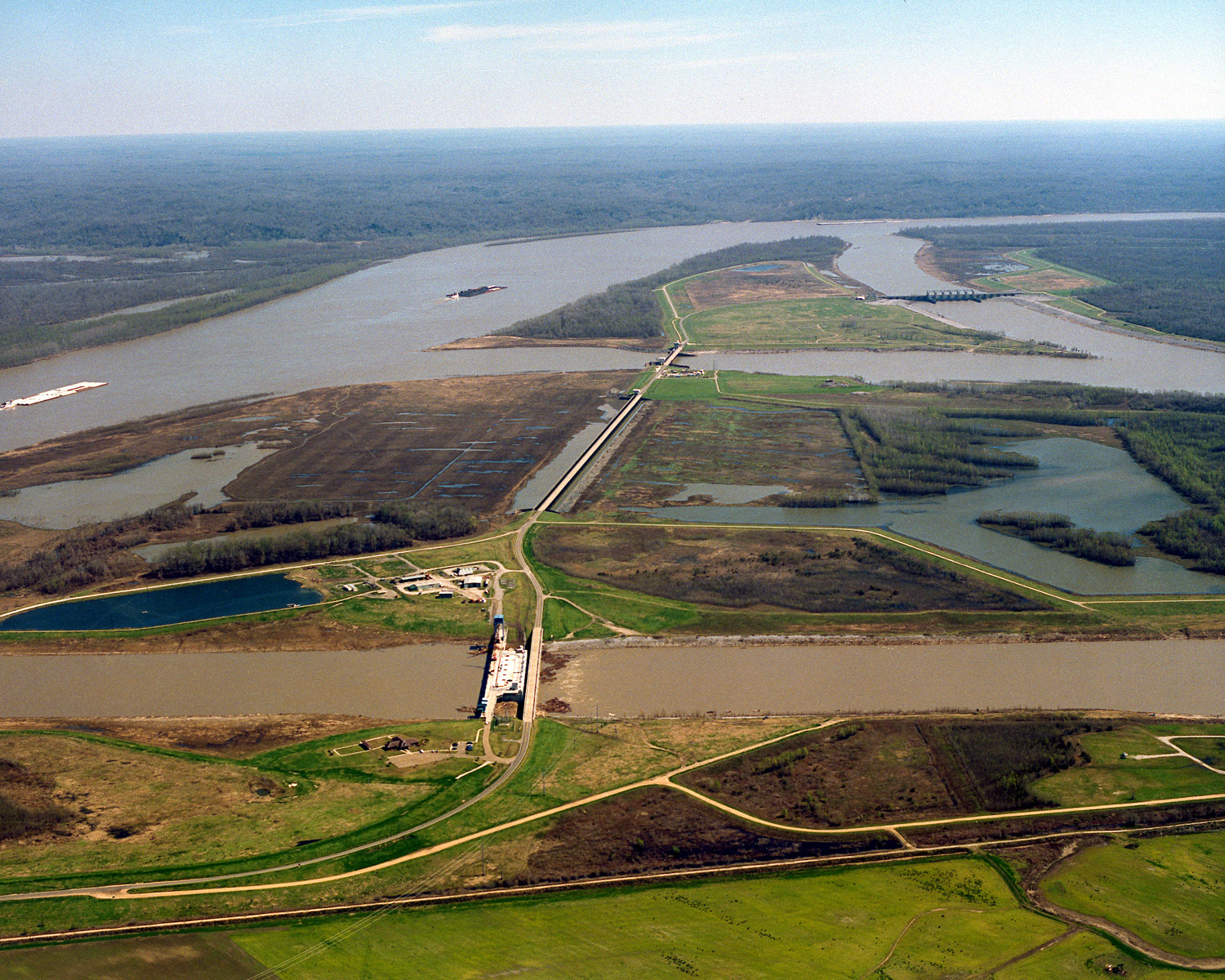
 The Old River Control Structure complex. View is to the east-southeast, looking downriver on the Mississippi, with the three dams across channels leading to the Atchafalaya River to the right of the Mississippi. Concordia Parish, Louisiana is in the foreground, on the right, and Wilkinson County, Mississippi, is in the background, across the Mississippi on the left.
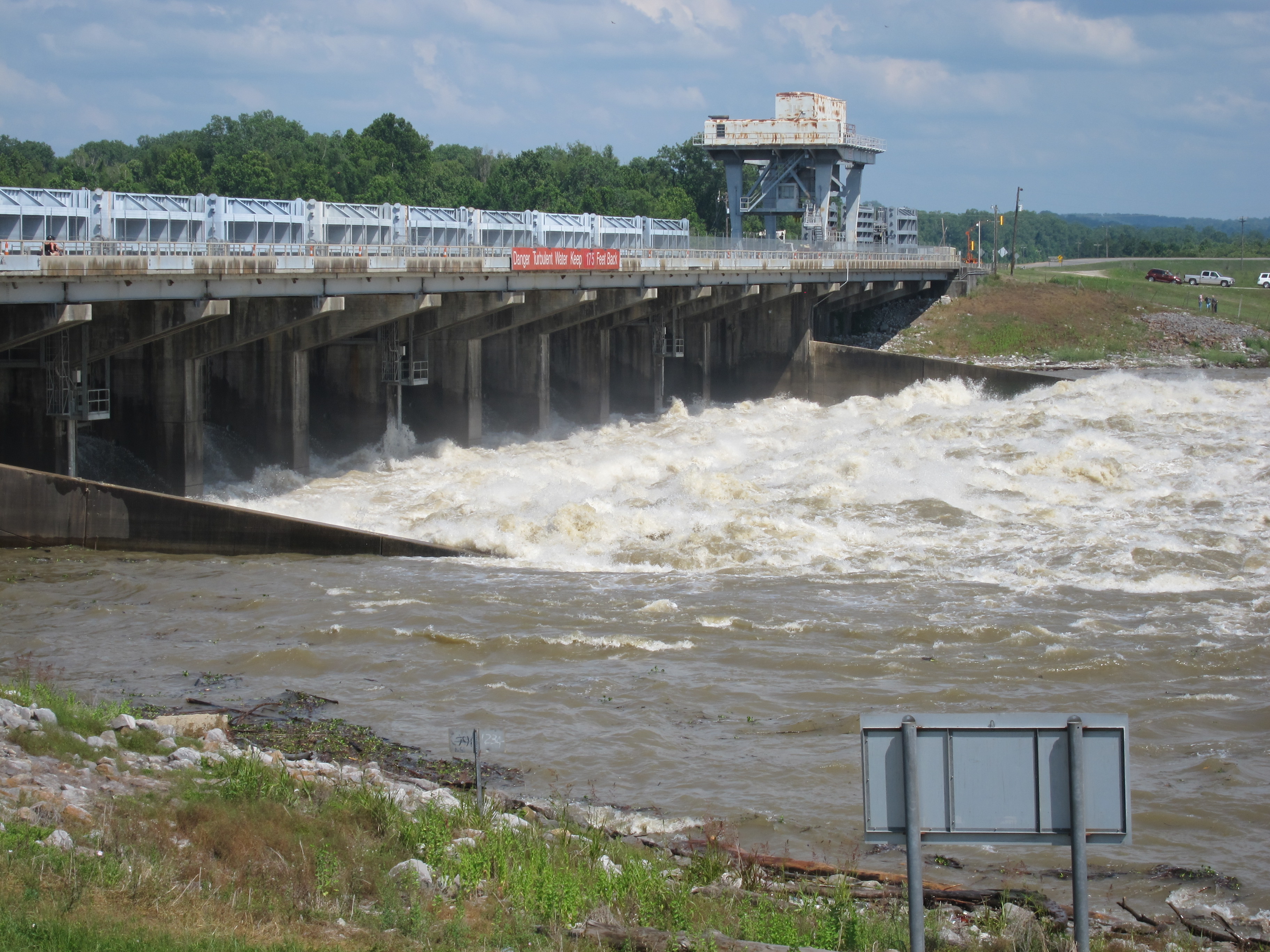
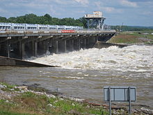 Old River Control Structure discharging water into the Atchafalaya, May 2011
The Old River Control Structure (ORCS) is a floodgate system located in a branch of the Mississippi River in central Louisiana. It regulates the flow of water leaving the Mississippi into the Atchafalaya River, thereby preventing the Mississippi river from changing course. Completed in 1963, the complex was built by the U.S. Army Corps of Engineers in a side channel of the Mississippi known as "Old River," between the Mississippi's current channel and the Atchafalaya Basin, a former channel of the Mississippi.[1][2][3][4][5]
Contents
Purpose
Although the Red River is currently a tributary of the Mississippi River and the Atchafalaya River a distributary of the Red River, it has not always been that way. Up until the 15th century A.D., the Red River and Mississippi River were entirely separate rivers and more or less parallel to one another.[3]
Beginning in the 15th century, though, the Mississippi River created a small westward loop, later renamed Turnbull’s Bend, near present-day Angola, La. This loop intercepted the Red River, and the Atchafalaya River was formed as a distributary.[3]
In the heyday of steamboats along the Mississippi River, it took a boat several hours to travel the bend’s 20 miles, and only then it had progressed a mile or so. To reduce travel time, Captain Henry M. Shreve, a river engineer and founder of Shreveport, La., dug a canal in 1831 through the neck of Turnbull’s Bend. At the next high water, the Mississippi roared through this channel.[6]
With the Mississippi River taking a new course, the Red River began emptying into the smaller Atchafalaya River. And the Atchafalaya River was force-fed by the Mississippi River at the abandoned Turnbull’s Bend, which had come to be known as "Old River.” With this extra intake of water, the Atchafalaya River wore deeper and wider throughout the 1800’s and early 1900’s.[6]
The U.S. Army Corps of Engineers measured the amount of water flowing through the Mississippi River and compared it to the amount entering the Atchafalaya Basin by monitoring “latitude flow” at the latitude of the Red River Landing, located five miles downstream of Old River. In this case, latitude flow is a combination of the flows of the Mississippi and Atchafalaya rivers as they cross an imaginary line at that latitude.[3]
Between 1850 and 1950, the percentage of latitude flow entering the Atchafalaya River had increased from less than 10 percent to about 30 percent. By 1953, the U.S. Army Corps of Engineers concluded that the Mississippi River could change its course to the Atchafalaya River by 1990 if it were not controlled, since this alternative path to the Gulf of Mexico through the Atchafalaya River is much shorter and steeper.[3]
The Corps completed construction on the Old River Control Structure in 1964 to prevent the main channel flow of the Mississippi River from altering its current course to the Gulf of Mexico through the natural geologic process of avulsion.[3][7] Historically, this natural process has occurred about every 1,000 years, and is overdue. Some researchers believe the likelihood of this event increases each year, despite artificial control efforts.[8]
If the Mississippi diverts its main channel to the Atchafalaya Basin and the Atchafalaya River, it would develop a new delta south of Morgan City in southern Louisiana, greatly reducing water flow to its present channel through Baton Rouge and New Orleans.[4] Integrity of the Old River Control Structure, the nearby Morganza Spillway, and other levees in the area is essential to prevent such a diversion; see "Mississippi River: Future course changes" for further discussion. Jeff Masters of Weather Underground noted that failure of that complex "would be a serious blow to the U.S. economy."[9]
Components
 A diagram that depicts river flows associated with a Project Design Flood.
The present Old River Control Structure was completed in 1964 and expanded in 1990. The first two floodgates are the Low Sill Control Structure, which regulates routine flow in the waterway, and the Overbank Control Structure, in use only when the Mississippi exceeds its banks. A navigation channel and lock were also part of the original facility design. Subsequent expansion created what is now known as the Old River Control Complex, when the Auxiliary Structure, which became operational in 1986, was added to reduce pressure on the original floodgates after extensive damage caused by the flood of 1973. The Sidney A. Murray, Jr. Hydroelectric Station, completed in 1990, also provides an additional measure of control at the site.[3]
Operation
Water from the Mississippi is normally diverted into the Atchafalaya Basin only at Old River, where floodgates are routinely used to redirect the Mississippi's flow into the Atchafalaya River such that the volume of the two rivers is split 70%/30%, respectively, as measured at the latitude of Red River Landing.[10][11].
Water diverted at Old River flows into the Atchafalaya Basin, first entering the Red River, then continuing down the Atchafalaya River to the Gulf of Mexico, bypassing Baton Rouge and New Orleans (see diagram).
The Morganza Floodway, between the Mississippi and the Atchafalaya Basin nearby downstream, is normally closed, but can be opened in an emergency to relieve water levels and water-pressure stress on various levees and other flood-control structures, including the Old River Control Structure. The floodway can reduce stress by diverting additional water from the Mississippi into the Atchafalaya.[12] The Morganza Floodway was never used before the construction of ORCS, and has only been opened twice (as of 2011) for flood control since completion of the ORCS.
See also
- Lower Mississippi
References
- ^ McPhee, John (Feb 23, 1987). "The Control of Nature: Atchafalaya". The New Yorker. http://www.newyorker.com/archive/1987/02/23/1987_02_23_039_TNY_CARDS_000347146. Retrieved 12 May 2011. Republished in McPhee, John (1989). The Control of Nature. Farrar, Straus and Giroux. pp. 272. ISBN 0-374-12890-1.
- ^ Angert, Joe and Isaac. "Old River Control". The Mighty Mississippi River. Archived from the original on May 15, 2009. http://replay.web.archive.org/20090515010700/http://users.stlcc.edu/jangert/oldriver/oldriver.html. Retrieved 2011-05-12.. Includes map and pictures.
- ^ a b c d e f g "Louisiana OLD RIVER CONTROL STRUCTURE and Mississippi river flood protection". America's Wetland Resource Center. Loyola University's Center for Environmental Communication (LUCEC). http://www.americaswetlandresources.com/background_facts/detailedstory/LouisianaRiverControl.html.
- ^ a b "Will the Mississippi River change its course in 2011 to the red line?". Mappingsupport. http://www.mappingsupport.com/p/gmap4.php?q=https://sites.google.com/site/gmap4files/p/news/mississippi_course_change.txt&ll=30.417887,-91.201416&t=h&z=9&label=on. Retrieved 2011-05-08.
- ^ Kemp, Katherine (January 6, 2000). "The Mississippi Levee System and the Old River Control Structure". http://www.tulane.edu/~bfleury/envirobio/enviroweb/FloodControl.htm.
- ^ a b Article in the New York Times
- ^ "Mississippi Rising: Apocalypse Now? (April 28, 2011)". Daily Impact. http://www.dailyimpact.net/2011/04/28/mississippi-rising-apocalypse-now/. Retrieved 10 May 2011.
- ^ Daniels, Ronald Joel (2006). On Risk and Disaster: Lessons from Hurricane Katrina. University of Pennsylvania Press. pp. 45.
- ^ http://www.wunderground.com/blog/JeffMasters/comment.html?entrynum=1798
- ^ "Mississippi River at Red River Landing (01120)". United States Army Corps of Engineers. May 07, 2011. http://www2.mvr.usace.army.mil/WaterControl/stationinfo2.cfm?sid=01120&fid=BTRL1&dt=S. Retrieved 10 May 2011.
- ^ "Daily State and Discharge Data - Water Control - New Orleans District". U.S. Army Corps of Engineers. http://www.mvn.usace.army.mil/eng/edhd/dailystagedisplay.asp. Retrieved 10 May 2011.
- ^ http://www.nola.com/environment/index.ssf/2011/05/morganza_floodway_opens_to_div.html
External links
- McPhee, John (February 23, 1987). "Atchafalaya". The New Yorker. http://www.newyorker.com/archive/1987/02/23/1987_02_23_039_TNY_CARDS_000347146. Retrieved 9 May 2011. (Section of The Control of Nature.)
- Information, photos, diagrams
- History, information
- History, maps
- Interactive and zoomable map or satellite photos
Categories:- Rivers of Louisiana
- Buildings and structures in Louisiana
- Buildings and structures in Concordia Parish, Louisiana
- Dikes in the United States
Wikimedia Foundation. 2010.