- Lock and Dam No. 1
-
Lock and Dam No. 1 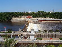
Ford Lock and Dam.Location Minneapolis
Saint Paul, MinnesotaCoordinates 44°54′55″N 93°12′02″W / 44.91528°N 93.20056°W Dam and spillways Length 574 feet (175.0 m) Impounds Upper Mississippi River Reservoir Creates Pool 1 
 Lock and Dam No. 1 (Minnesota)
Ford Dam, officially known as Lock and Dam No. 1 is on the Upper Mississippi River and is located between Minneapolis and Saint Paul, Minnesota just north of the confluence of the Mississippi with the Minnesota River. The dam portion was previously owned by the Ford Motor Company, which operated a hydroelectric power station to feed electricity to its Twin Cities Assembly Plant on the east side of the river. It was sold to Brookfield Power Co. in 2007. The dual-lock facility is operated by the St. Paul district of the U.S. Army Corps of Engineers' Mississippi Valley Division.[1][2][3]
History
The first facility at the site went into operation in 1917 and superseded the role of the earlier Lock and Dam No. 2 (today known as the Meeker Island Lock and Dam). The facility was rebuilt in 1929, and an expansion from one lock to two locks was completed in 1932. Each lock is 56 feet (17 m) wide by 400 feet (120 m) long (17 × 122 meters), half the width of the next lock downstream, though this is the only dual-lock facility in the district. Major rehabilitation efforts were carried out between 1978 and 1983, including the replacement of many manual and hydraulic components with computer controls.
The eastern portion of the site consists of an overflow Ambursen dam, which is a buttress dam where the upstream part is a relatively thin flat slab usually made of reinforced concrete. There is an inflatable section on top of the dam that can slightly increase its size when so desired. The lock side of the facility has a large observation area that is open from April to November each year. A bridge allows visitors to walk over the two locks and right up next to the dam.
When the facility opened, it assured a navigable channel up to the tail end of Saint Anthony Falls upriver in Minneapolis. Additional locks were added there in the 1960s, extending the head of navigation to the northern part of the city. A dam in Coon Rapids (without any lock) prevents travel any further to the north.
Just upstream of the dam is the Ford Parkway Bridge.
On August 2, 2007, Lower St. Anthony Falls Lock and Dam gates were adjusted to lower the water level of the Mississippi by 2 feet (0.61 m) to assist in the recovery efforts of the victims of the I-35W bridge collapse (sometimes called Bridge 9340).
References
- ^ USACE St. Paul District: Lock and Dam No. 1
- ^ The Secret History of the Mississippi's Earliest Locks and Dams (PDF)
- ^ Survey number HAER MN-62 - Mississippi River 9-foot (2.7 m) Channel, Lock & Dam No. 1, In Mississippi River at Mississippi Boulevard, below Ford Parkway Bridge, Saint Paul, Ramsey County, MN
- McMahon, Brian, Minneapolis and St. Paul Stumble- Henry Ford Wins the Struggle for the High Dam, Ramsey County History Quarterly V42 #2, Ramsey County Historical Society, St Paul, MN, 2008.
External links
- [1] - Website of the Ramsey County Historical Society, St Paul MN, with an online exhibit sharing photos of the construction of the Ford High dam from an article in the Ramsey County History Quarterly V42 #2.
 Towboat Patrick Ganmaway taking a load of sand and gravel through Lock Number 1
Locks and dams of the Upper Mississippi River USAF • LSAF • 1 • 2 • 3 • 4 • 5 • 5A • 6 • 7 • 8 • 9 • 10 • 11 • 12 • 13 • 14 • 15 • 16 • 17 • 18 • 19 • 20 • 21 • 22 • 24 • 25 • 26 • 27 Upstream:
Meeker Island Lock and Dam (former Lock and Dam No. 2, demolished)Downstream:
Lock and Dam No. 2Coordinates: 44°54′55″N 93°12′02″W / 44.91528°N 93.20056°W
Categories:- Buildings and structures in Minneapolis, Minnesota
- Buildings and structures in Saint Paul, Minnesota
- Dams in Minnesota
- Mississippi National River and Recreation Area
- Mississippi River locks


Wikimedia Foundation. 2010.