- Mississippi River Watershed Conservation Programs
-
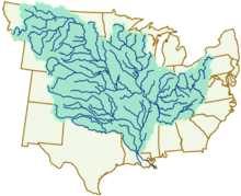 Mississippi River Watershed
Conservation programs for the Mississippi River watershed are designed to protect and preserve the Mississippi River and the surrounding area by implementing practices that decrease the harmful effects on habitats due to development and also overlook monitoring that helps to support future planning and management. A main focus of many conservation programs is nutrient pollution from agricultural runoff as well as problems relating to sediment and toxins. Farming in the Mississippi River basin supplies most of the nation's soybean and corn and is a major contributor to nutrient and sediment loadings. Conservation programs work with local farmers and producers to decrease excess nutrients because they cause major water quality problems along with hypoxia and loss of habitat. Organizations such as the Mississippi River/Gulf of Mexico Watershed Nutrient Task Force and programs such as the Upper Mississippi River Forestry Partnership and the Mississippi River Basin Healthy Watersheds Initiative contribute to conserving what is left of the Mississippi River Watershed.
Contents
Conservation of the Mississippi River
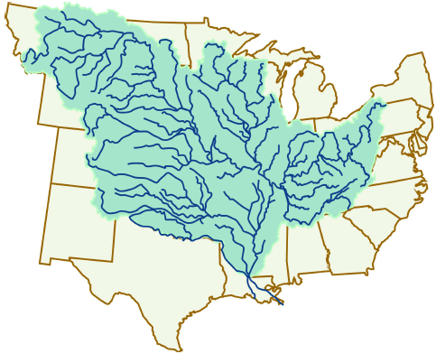
Conservation of the Mississippi River Watershed has become an important issue that many organizations are undertaking because the capacity of the river to remove nutrients from the water is decreasing and the surrounding ecosystems are being diminished. The Mississippi River Basin encompasses 31 U.S. states with an area of 1,837,000 square miles.[1] The Mississippi River's capacity to remove nutrients has diminished due to a range of human activities, such as development, taking place along the Mississippi River itself and the streams and tributaries linked to it. The layouts of the river, the floodplains, and the watershed have also been modified using engineering techniques for acres of agriculture fields and urban expansion. With increase of natural prairie land being converted to land for agricultural and urban use, there has been an excess of nutrients that are discharged into the Mississippi River and its adjoining streams.
Organizations and programs
Mississippi River/Gulf of Mexico Watershed Nutrient Task Force
The Mississippi River/Gulf of Mexico Watershed Nutrient Task Force undertakes the challenge of eliminating the dead zone in the Gulf of Mexico as well as promoting the implementation of new farming practices and nutrient runoff management. The Mississippi River dumps high nutrient runoff from the vast drainage basin into the Gulf of Mexico causing an outbreak of algae growth. The excess algae create an area where the dissolved oxygen concentration is very low in the bottom waters.[2] Many organisms cannot tolerate low-oxygen levels and either leave the area or become weakened or die from lack of oxygen. A majority of the nutrient loadings originate from the draining of agricultural lands north of the Ohio River in the states of Iowa, Illinois, Indiana, southern Minnesota, and Ohio.[3]
2001 Action Plan
The 2001 Action Plan is a national strategy to reduce Gulf hypoxia with a focus on reducing the nitrogen and phosphorus nutrient loads to the northern Gulf coming from the Mississippi River. The Action Plan proposes three goals: a Coastal Goal, a Within Basin Goal, and a Quality of Life Goal.[3] The Coastal Goal intends to reduce the square mileage of hypoxia in the Gulf to 5,000 square kilometers by the implementation of actions to reduce the discharge of nutrients into the Gulf. The Within Basin Goal is to restore and protect the waters of the Mississippi River Basin by implementing nutrient and sedimentation reduction actions that will protect human health and aquatic organisms and reduce the nutrient load released into the Gulf. Lastly, the Quality of Life Goal is to improve communities across the Mississippi River Basin through land management and an incentive based approach. The Action Plan states that by December 2005, and every five years thereafter, the Task Force will review the reductions in nutrient load discharge and the response of the dead zone in the Gulf. From this data, the Task Force would then decide what actions to take to continue achieving the goals.
2008 Action Plan
The 2008 Action Plan further describes a national strategy to address the problem with hypoxia in the Gulf of Mexico and also improve the water quality in the Mississippi River. The 2008 Action Plan was a reassessment called for in the 2001 Action Plan. The 2008 Action Plan outlines the significance of completing and implementing nutrient reduction strategies, promoting these practices, and also increasing the awareness of the public of hypoxia in the Gulf. Included in the 2008 Action Plan is a series of five Annual Operating Plans, one for each of the upcoming years until the next reassessment is necessary.[4] These Operating Plans offer guidelines to keep the forward movement of completing Action Plan goals within those years. The 2008 Action plan also summarized the progress of the 2001 Action Plan up until that point. Although the goal of reducing the size of the hypoxia area to 5000 square kilometers was not met, the loadings of nitrogen from the Mississippi River were decreased by 12%.[4]
Upper Mississippi River Initiatives
Upper Mississippi River Forestry Partnership
The USDA Forest Service and Northeastern Area State and Private Forestry and other local state foresters have created a partnership to demonstrate forestry's role in restoring the Upper Mississippi River Watershed. Forests are critical in protecting the surrounding watershed and the water quality. Nearly all of the prairies and 70% of the forests in the Upper Mississippi Watershed have been converted to land for agricultural and urban use.[5] The mismanagement of this area has had major effects on wildlife and their habitat.
Upper Mississippi Watershed Forestry Partnership Action Plan (2004-2008)
The Upper Mississippi Watershed Forestry Partnership Action Plan proposes the use of forests and trees to lessen the impact of the altered landscapes that the Mississippi River watershed has experienced for numerous decades. Due to the existing damage to the watershed and the tremendous cost of technological solutions, the problems cannot be solved with technology but instead with the natural ecosystems. These efforts include incentives to create wetlands and forest buffers between farmland and nearby rivers and streams to filter nutrients and by conservation of woodlands and reestablishing forest habitats to help maintain water quality.
Mississippi River Basin Healthy Watersheds Initiative
The Mississippi River Basin Healthy Watersheds Initiative (MRBI) was developed by the United States Department of Agriculture (USDA) Natural Resources Conservation Service (NRCS) in attempt to improve the health of the Mississippi River Basin. The Initiative will select watersheds to improve in 12 states including Arkansas, Kentucky, Illinois, Indiana, Iowa, Louisiana, Minnesota, Missouri, Mississippi, Ohio, Tennessee, and Wisconsin. The MRBI will build upon the past efforts of producers, NRCS, partners, and State and Federal agencies in this area. By dedicating $80 million in each year from 2010 to 2013, the Initiative will introduce local producers in the Mississippi River Watershed to conservation practices that will control nutrient runoff from agricultural land.[6] These practices will help to reduce nutrient loadings downstream, improve water quality, and restore habitats while still maintaining agricultural productivity.
Each of the 12 states will select three area watersheds that the MRBI will focus on. The selection is based on the future growth of the site depending on current water quality data, current strategies to reduce nutrient discharge, and current models of nitrogen and phosphorus in the watershed. Special consideration will be given to watersheds that will have the largest impact on managing nutrients.[6]
Approved MRBI Conservation Practices
The watersheds that were selected to participate in the MRBI must implement a system of practices that address the problem of nitrogen and phosphorus generation. Practices approved by the MRBI help avoid, trap, and control nutrients from agricultural runoff. There are multiple core and supporting conservation practices approved to provide options for producers depending on their location and existing operations. Approved core practices were selected based on what proved to be most important in reducing the downstream loading of nutrients. Core practices include planting cover crops, constructing grassed waterways or riparian forest buffers, and wetland creation or enhancement. The NRCS allowed State Conservationists to choose supporting practices that address the primary water concerns that have developed within that particular state. Supporting practices include pasture and hayland planting, deep tillage in fields, field borders, and constructing a water and sediment control basin. Payment is received as the implementation of core and supporting practices are proceeded in a selected watershed.
References
- ^ Mississippi River Facts, www.nps.gov, July 10, 2009, accessed October 27, 2009.
- ^ Hypoxia 101, www.epa.gov, accessed October 27, 2009.
- ^ a b 2001 Action Plan, www.epa.gov, accessed October 27, 2009.
- ^ a b 2008 Action Plan, www.epa.gov, accessed November 1, 2009.
- ^ Upper Mississippi Watershed Partnership Action Plan, www.na.fs.fed.us, accessed October 27, 2009.
- ^ a b Mississippi River Basin Healthy Watersheds Initiative, www.nrcs.usda.gov, accessed October 27, 2009.
Categories:
Wikimedia Foundation. 2010.