Chain of Rocks Lock

Chain of Rocks Lock
Chain of Rocks Lock

Lock number 27.
Official name Locks 27
Location Madison County, near Granite City, Illinois, USA
Dam and spillways
Impounds Upper Mississippi River


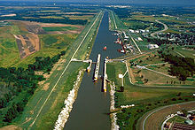
Chain of Rocks Lock, also known as Locks #27, is a lock situated on the southern end of Chouteau Island near St. Louis, Missouri on the Upper Mississippi River. Its associated dam is just downstream of the Chain of Rocks Bridge and the lock is located over three miles (5 km) south east, on the Chain of Rocks canal bypassing an unnavigable portion of the river.

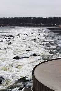
The 1200 feet (366 m) main lock and 600 feet (183 m) auxiliary lock were built in the late 1940s and early 1950s to allow a by-pass of the Chain of Rocks lying in the main channel of the Mississippi River. This stretch of river in low water seasons was treacherous for commercial tow boats and barges, often requiring them to wait up to several days for the river to rise. Lock 27 is the only lock on the Mississippi River System without a man made dam. Tons of rock were laid in the Mississippi to create a small pool elevation upstream from the Chain of Rocks. The drop at Locks 27 can vary from a few feet to over a ten foot drop depending on the river stage.

Locks #27 and the Chain of Rocks canal take traffic around this "chain of rocks", an anticlinal exposure of bedrock in the river north of St. Louis. The low water dam runs on the right of the image starting at the round sheet pile cells at bottom left.

The Chain of Rocks Lock is operated by the St. Louis District of the U.S. Army Corps of Engineers. Locks #27 are the southernmost locks on the Mississippi River and they are the only Locks south of the confluence of the Mississippi River and Missouri River. As such, the Locks move more cargo than any other navigation structure on the Mississippi River.

See also

External links

The Chain of Rocks Canal and Locks in Madison County, Illinois
Locks and dams of the Upper Mississippi River
USAFLSAF123455A67891011121314151617181920212224252627
Upstream:
Melvin Price Locks and Dam
Downstream:
no further locks and dams

Coordinates: 38°42′11″N 90°10′51″W / 38.70306°N 90.18083°W / 38.70306; -90.18083


Wikimedia Foundation. 2010.

Игры ⚽ Поможем решить контрольную работу

Look at other dictionaries:

  • Chain of Rocks Bridge — Carries Pedestrians and bicycles Crosses Mississippi River Locale …   Wikipedia

  • Mieminger Chain — Coordinates: 47°21′00″N 10°59′00″E / 47.35°N 10.9834°E / 47.35; 10.9834 …   Wikipedia

  • Mississippi River — For the river in Canada, see Mississippi River (Ontario). Coordinates: 29°09′04″N 89°15′12″W / 29.15111°N 89.25333°W / …   Wikipedia

  • Chouteau Island — (pronounced /ʃuːˈtoʊ/ shoo toh), situated approximately 8 miles (13 km) due north of the St. Louis, Missouri Gateway Arch and approximately 1 mile (2 km) south of the confluence of the Missouri River and Mississippi River, is one of a… …   Wikipedia

  • Upper Mississippi River — Infobox River | river name = Upper Mississippi River caption = The Upper Mississippi River near Harpers Ferry, Iowa origin = Lake Itasca, Minnesota coord|47.253|N|95.212|W| mouth = Cairo, Illinois (flows into Lower Mississippi River)… …   Wikipedia

  • Melvin Price Locks and Dam — (Lock and Dam number 26) Location Alton, Illinois / West Alton, Missouri, USA …   Wikipedia

  • List of Historic Civil Engineering Landmarks — The following is a list of Historic Civil Engineering Landmarks as designated by the American Society of Civil Engineers since it began the program in 1964. The designation is granted to projects, structures, and sites in the United States… …   Wikipedia

  • Missouri locations by per capita income — Missouri is the thirtieth richest state in the United States of America[citation needed], with a per capita income of $19,936 (2000).[1] Missouri places ranked by per capita income Baker, Missouri – $182,000 Huntleigh, Missouri – $104,420 Country …   Wikipedia

  • List of historic civil engineering landmarks — The following is a partial list of historic civil engineering landmarks as designated by the American Society of Civil Engineers since it began the program in 1964. The designation is granted to projects, structures, and sites in the United… …   Wikipedia

  • Big Dam Bridge — Infobox Bridge bridge name= Pulaski County Pedestrian and Bicycle Bridge caption= official name= Pulaski County Pedestrian and Bicycle Bridge also known as= Big Dam Bridge carries= Pedestrians and bicycles crosses= Arkansas River locale= Little… …   Wikipedia

Share the article and excerpts

Direct link
Do a right-click on the link above
and select “Copy Link”