- Lock and Dam No. 19
Infobox_Dam
dam_name=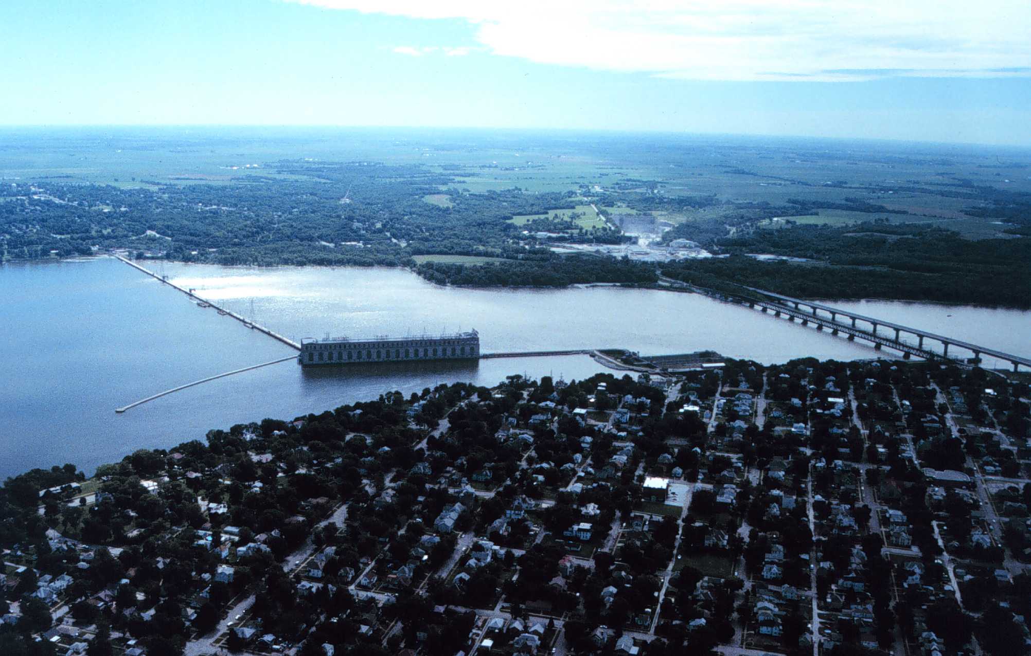
caption=Mississippi River Lock and Dam number 19
official_name=
crosses=Upper Mississippi River
reservoir=Pool 19 / Lake Cooper
locale=Keokuk, Iowa Hamilton, Illinois
maint=United States Army Corps of Engineers
length= convert|4620|ft|m|1 (movable portion)
height=
width=
began=1910
open=1913
closed=
reservoir_capacity=
reservoir_catchment=
reservoir_surface=
coordinates= coord|40|23|45.46|N|91|22|26.71|W|region:US_type:landmark
extra=location map|Iowa|label= |lat_deg=40|lat_min=23|lat_sec=51|lon_deg=-91|lon_min=-22Lock and Dam No. 19 is a lock and
dam located on the UpperMississippi River near Keokuk,Iowa . In 2004, the facility was listed in theNational Register of Historic Places as Lock and Dam No. 19 Historic District, #04000179 covering convert|1605|acre|km2|1, 7 buildings, 12 structures, 1 object. The lock and dam are owned and operated by theU.S. Army Corps of Engineers .The lock and dam obliterated the
Des Moines Rapids which had effectively been the northern barrier for traffic on the Mississippi until efforts began in 1837 to address the Mississippi's 2.5 foot depth in the rapids.Locks
The main lock was constructed from 1952 to 1957 and is convert|1200|ft|m|1 long and convert|110|ft|m|1 wide with a lift of just over 38 feet and large enough to handle a full-length fleet of barges. It was put into operation in 1957 at a cost of 13.5 million dollars. The 1957 lock replaced a 1910-1913 lock. The 1913 lock was a variant of the standardized Panama canal design and was convert|110|ft|m|1 wide, convert|358|ft|m|1 long and convert|57|ft|m|1 tall with a convert|40|ft|m|1 lift. There was a convert|130|ft|m|1 wide, convert|463|ft|m|1 long and convert|20|ft|m|1 deep dry dock at the site, both the dry dock and 1913 lock were dewatered in 1977 when a sheet pile and cell closure were built blocking the upstream sides of the lock and dry dock. [http://hdl.loc.gov/loc.pnp/hhh.ia0185 HAER - Mississippi River 9-Foot Channel, Lock & Dam No. 19, Upper Mississippi River, Keokuk, Lee County, IA] ]
With a convert|38|ft|m|1 difference between the normal pool above and below the dam, the lock has the highest "step" in the stairway of the Rock Island District locks and dams.Fact|date=February 2007 The lock and dam, as well as the rest of the river, can be viewed from a distance on the Observation Deck of the
Keokuk Rail Bridge .Dam
The movable portion of the dam is convert|4620|ft|m|1 long with 119 separate convert|30|ft|m|1 rectangular, steel-skin plated, sliding gates and its construction began in 1910, and when completed in 1913. The gates are either installed or removed and river flow is controlled by the number of gates installed. They are removed by a gantry crane that travels on the service bridge above the dam. At the time it was completed it was second in length only to the Aswan (low) dam on the
Nile River . Hugh L. Cooper was the designer of the "Keokuk Dam". The pool created behind the dam, Lake Cooper, is named in his honor and is the largest pool in the series of dams with 240 miles of shoreline.Fact|date=February 2007Powerhouse
Construction began in 1910, and when completed in 1913, it was the largest capacity, single powerhouse electricity generating plant in the world. The Power House and spillways are owned and operated by Ameren Power Company and has a 134 MW capacity. [https://www.ameren.com/AboutUs/ADC_AU_FactSheet.pdf] The powerhouse contains 15 generators, originally designed to produce 25 Hz instead of the 60 Hz
alternating current used today. Lock and Dam No. 1,Lock and Dam No. 2 and the upper St. Anthony Falls dam also produce electricity.ee also
*
Keokuk Rail Bridge
*Keokuk-Hamilton Bridge References
External links
* [http://hdl.loc.gov/loc.pnp/hhh.ia0185 HAER - Mississippi River 9-Foot Channel, Lock & Dam No. 19, Upper Mississippi River, Keokuk, Lee County, IA]
* [http://www.keokukiowatourism.org/lock.htm Keokuk Area Convention and Tourism Bureau]
* [http://www.ameren.com/aboutus/adc_au_Keokuk.asp AmerenUE Keokuk Power Plant fact sheet]
* [http://www-tech.mit.edu/archives/VOL_034/TECH_V034_S0395_P001.pdf Hugh L. Cooper speaks to MIT civil engineers Jan. 1915]
Wikimedia Foundation. 2010.