- Michigan Road
-
 Michigan Road, as well as other early roads, in Indiana
The Michigan Road was one of the earliest roads in Indiana. Roads in early Indiana were often roads in name only. In actuality they were sometimes little more than crude paths following old animal and Native American trails and filled with sinkholes, stumps, and deep, entrapping ruts. Hoosier leaders, however, recognized the importance of roads to the growth and economic health of the state, and the needed improvements. They encouraged construction of roads which would do for Indiana what the National Road was doing for the whole country.
As early as 1821 the legislature earmarked funds for more than two dozen roads throughout the state. Roadbuilding was often the responsibility of the counties, which were empowered to call out a local labor force for construction and provide road viewers, or supervisors.
Contents
History
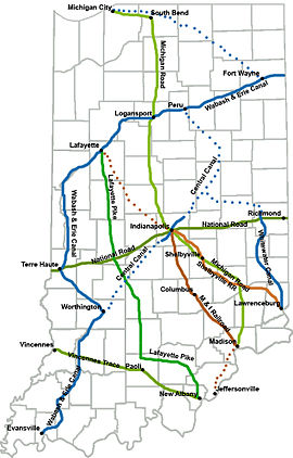
Indiana's first "super highway" was the Michigan Road, which was built in the 1830s and 1840s and ran from Madison, Indiana to Michigan City, Indiana via Indianapolis. Like the National Road, it did much to spur settlement and economic growth. One-half of the pioneers to settle northwestern Indiana did so by using the Michigan Road to travel from the Ohio River to their destination.[1] It was the "most ambitious" project to connect Indianapolis with the rest of the state, despite being never more than a "muddy road".[2]
One of the things that made the road possible was a treaty the state of Indiana forged with the Pottawatomie on October 16, 1826. Governor James B. Ray led the negotiations. It allowed for a ribbon of land 100 feet (30 m) wide to stretch from the Ohio River (at Madison) to Lake Michigan (Michigan City).[3] The Pottawatomie left the region by the very road when the last of their tribe was forcibly removed in the 1836 Pottawatomie Trail of Death.[4]
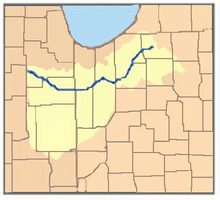 Watershed of the Kankakee River
A commission was selected to route the road from Indianapolis to Lake Michigan in 1828. It was told to make the trailhead be the best harbor, preferably natural, that could be had with Lake Michigan. The Kankakee River's swamp posed a problem for the construction of the road, forcing the commission to avoid a more direct northwesterly route and instead have it go from Logansport, Indiana straight up to the south bend of the St Joseph River (now South Bend, Indiana), and then west to Lake Michigan.[5] Michigan City was formally selected to be the trailend in 1832.[2]
The route from Madison to Indianapolis was straighter. From Madison it went north through Ripley and Jefferson counties straight to Napoleon, Indiana, and from there straight through Shelby County, Indiana to Indianapolis.[1]
It proved to be the preferred route to Indianapolis for 34 separate counties, even through the road only went through 14 counties. In 1836 the Indiana General Assembly passed the Mammoth Internal Improvement Act, the act provided funds to pave the entire length of the road. However, the economic difficulties brought on by overspending and the Panic of 1837 caused the state to enter partial bankruptcy before the entire length could be paved. The situation forced Indiana to give control of the road to the individual counties as part of a plan to avoid losing it to the state's creditors.[1]
Today
Indiana State Road 29, originally much longer, followed the route from Madison to Bryantsburg, and from Napoleon in the south to Logansport in the north. Indiana State Road 25 followed the original route to Rochester, Indiana. U.S. Route 31 followed the original route from Rochester to South Bend, Indiana. Indiana State Road 2 and U.S. Route 20 follow the original road from South Bend to Michigan City.
The later U.S. Route 421 replaced Indiana State Road 29 from Madison to near Boyleston; the original route for US 421 was altered when Interstate 465 was constructed.[2] A more "truck friendly" route was also built from Madison to North Madison. (The section of US 421 from Bryantsburg to Napoleon through Versailles was originally made SR 29 to conform with the law creating the state highway system in 1919.)
The original US 31 has been bypassed in several locations, most notably, in terms of the Michigan Road, from Rochester to north of Plymouth, Indiana. SR 29 from the south into Logansport has been decommissioned, as has the entire route (that which remains) from north of Greensburg (JCT I-74/US 421) to the northwest side of Indianapolis (JCT I-465/US 421).
In Indianapolis, a few remnants of the road still remain. In particular stands a tollhouse the Augusta Gravel Road Company placed to recoup their costs in repairing the road. It stands just north of the White River.[2]
A monument marking the intersection of the Michigan Road and the National Road exists at the corner of Washington Street and Southeastern Ave. near downtown Indianapolis. This monument was relocated slightly as part of the changes to Interstate 65 exits in 2008.[6]
Historical markers
Michigan Road related markers in Indiana include:
Boone County, Indiana: MICHIGAN ROAD - With proceeds from the sale of 170,580 acres (690.3 km2) of Indian land granted by the Federal Government, Indiana built its first north-south road. Surveyed 1829, passable by 1834, "completed" in 1837, its cost was $242,000.00. [2] (Location: West side of US 421, north of 121st Street, north & east of Zionsville.)
Fulton County, Indiana: MICHIGAN ROAD - Extending from Michigan City to the Ohio River at Madison. Begun by the state in 1832 with funds obtained from sale of land granted by the Potawatomi Indians. Opened northern part of state to settlers. [3] (Location: Old US 31 at Tippecanoe River bridge, SE corner, 3 miles (4.8 km) north of Rochester.)
Marion County, Indiana: TOLL HOUSE - Operated by Augusta Gravel Road Co., circa 1866-1892. MICHIGAN ROAD - First major state road, built in the 1830's, from the Ohio River to Lake Michigan. [4] (Location: 4702 N. Michigan Road/Old US 421, Indianapolis.)
Ripley County, Indiana: MICHIGAN ROAD - Extending from Michigan City to the Ohio River at Madison. Begun by the state in 1832 with funds obtained from sale of land granted by the Potawatomi Indians. Opened northern part of state to settlers. [5] (Location: US 50 and N. Old Michigan Road, 2 miles (3.2 km) east of Holton.)
See also
- Buffalo Trace (road)
- Michigan Avenue or the Chicago Road, an early road connecting Detroit and Chicago
- National Road
References
Sources
- Bodenhamer, David (1994). The Encyclopedia of Indianapolis. Indiana University Press. ISBN 0253312221.
- Esarey, Logan (1915). A History of Indiana. W.K. Stewart co..
Categories:- Historic trails and roads in the United States
- Historic trails and roads in Indiana


Wikimedia Foundation. 2010.