- Interstate 465
-
Interstate 465
USS Indianapolis Memorial Highway 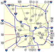
Route information Maintained by INDOT Length: 53 mi[1] (85.30 km) Existed: 1959 (completed 1970) – present Major junctions Beltway around Indianapolis, Indiana  I-65
I-65
 I-70
I-70
 I-74
I-74
I-65
 I-865
I-865
 I-69
I-69
I-70
I-74Highway system Auxiliary route of the Interstate Highway System
Main • Auxiliary • BusinessIndiana roads
Interstates • U.S. Routes • State Roads • Former←  SR 462
I-469  →
→Interstate 465 (I-465), also known as the USS Indianapolis Memorial Highway, is the beltway circling Indianapolis, Indiana, United States. It is roughly rectangular in shape and has a perimeter of approximately 53 miles (85 km). It lies almost completely within the boundaries of Marion County, except for two short sections on the north leg in Boone and Hamilton Counties. It crosses I-65, I-69, I-70 and I-74, and provides additional access to I-65 via I-865. An $800 million project is underway to refurbish the western edge of the loop, with an estimated completion in 2014.[2]
Contents
Route description
Except for I-65 and I-70, no numbered highways run through downtown Indianapolis. All highways that continue from one side to the other are routed around the city, concurrent with I-465:
- Interstate 74, counterclockwise from exit 16 to exit 49
- U.S. Highway 31, counterclockwise from exit 2 to exit 31
- U.S. Highway 36, counterclockwise from exit 13 to exit 42
- U.S. Highway 40, counterclockwise from exit 12 to exit 46
- U.S. Highway 52, clockwise from exit 25 to exit 47 (originally counterclockwise from exit 20 to exit 48[3])
- U.S. Highway 421, counterclockwise from exit 49 to exit 27
- State Road 37, counterclockwise from exit 4 to exit 37 (originally only from exit 4 to exit 2[4])
- State Road 67, counterclockwise from exit 8 to exit 42
The approximately one-mile section between exits 46 and 47 carries eight routes — I-465, US 31, US 36, US 40, US 52, US 421, SR 37 and SR 67. It may also carry Interstate 69 in the future.
In most cases, markers other than I-74's are not posted along I-465 itself; rather, signs on the onramps direct traffic following a particular route to follow I-465 to a particular exit to continue on that route.[5]
History
Much of I-465 replaced the routing of the defunct parallel State Road 100.
In 2002, the Interstate 865 designation was created from a portion of I-465 to eliminate the three-way intersection of I-465.
Also in 2002, Indianapolis native David Letterman's late-night talk show sidekick and band leader Paul Shaffer was honored by having a street in Thunder Bay, Ontario, named for him. This led Letterman to ask (on his program) why he couldn't have his own eponymous road, and he suggested I-465 be named the David Letterman Expressway. His fans took the idea seriously, especially in the Indianapolis area where highway signs promoting the idea were displayed. Advertisers and traffic reports started to refer to I-465 as the "DLX", or later the "David Letterman Bypass", a reference to his quintuple heart bypass surgery in January 2000. Letterman even telephoned the Mayor of Indianapolis, Bart Peterson to make his case, but eventually the idea went nowhere.
In 2011 the Indiana General Assembly passed a resolution naming I-465 as the USS Indianapolis Memorial Highway in "the memory of the brave sailors who lost their lives" when the USS Indianapolis was sunk in the Pacific during World War II.[6]
Exit list
County Location Mile Exit Destinations Notes Marion Indianapolis 2  US 31 south (East Street) – Greenwood
West end of US 31 overlap; signed as exits 2A (north) and 2B (south) 4  SR 37 south (Harding Street) – Bloomington
West end of SR 37 overlap 7 Mann Road Westbound exit and eastbound entrance 8  SR 67 south (Kentucky Avenue) – Vincennes
West end of SR 67 overlap 9  I-70 – Indianapolis, Terre Haute, Indianapolis International Airport, St. Louis
Signed as exits 9A (east) and 9B (west); Exit 73 on I-70 11 Sam Jones Expressway 12  US 40 west (Washington Street) – Terre Haute, Plainfield
West end of US 40 overlap 13  US 36 west (Rockville Road) – Avon, Danville, Rockville
West end of US 36 overlap 14 10th Street Speedway 16  I-74 west (Crawfordsville Road) / US 136 west – Peoria
West end of I-74 overlap; eastern terminus of US 136; signed as exits 16A for US 136 and 16B for I-74 Indianapolis 17 38th Street 19 56th Street Northbound exit and southbound entrance 20 I-65 – Indianapolis, Gary, Chicago21 71st Street, 73rd Street 23 86th Street Boone Zionsville 25  I-865 west / US 52 west to I-65 north – Chicago
West end of US 52 overlap Marion Indianapolis 27  US 421 north (Michigan Road) – Michigan City
West end of US 421 overlap Hamilton Carmel 31 US 31 north (Meridian Street) – South BendEast end of US 31 overlap Marion Indianapolis 33 Keystone Avenue (Former SR 431) 35 Allisonville Road 37 I-69 (Binford Boulevard) / SR 37 north – Fort Wayne, MuncieEast end of SR 37 overlap; signed as exits 37A (south) and 37B (north) westbound 40 Shadeland Avenue; 56th Street Lawrence 42 US 36 east (Pendleton Pike) / SR 67 north – PendletonEast end of US 36 / SR 67 overlap Indianapolis 44 I-70 – Indianapolis, DaytonSigned as exits 44A (east) and 44B (west) northbound 46 US 40 east (Washington Street) – RichmondEast end of US 40 overlap 47 US 52 east (Brookville Road) - CincinnatiEast end of US 52 overlap 48 Shadeland Avenue Northbound exit and southbound entrance 49 I-74 east (Southeastern Avenue) / US 421 south – CincinnatiEast end of I-74 / US 421 overlap Beech Grove 52 Emerson Avenue Indianapolis 53 I-65 – Indianapolis, LouisvilleSigned as exits 53A (north) and 53B (south) 1.000 mi = 1.609 km; 1.000 km = 0.621 mi
Concurrency terminus • Closed/Former • Incomplete access • UnopenedFuture
Eventually, Interstate 69 will run concurrent with Interstate 465 clockwise around Indianapolis from the current south end to somewhere between exits for Indiana State Road 37 and Indiana State Road 67 on the south side.
References
- ^ Indiana Highway Ends - I-465
- ^ ([dead link]) Accelerate 465, I-465 expansion project, http://www.ai.org/dot/div/projects/accelerate465/design/
- ^ 1969 Indianapolis map (note that the highlighting is wrong, as exit 47 was a partial interchange, so US 52 had to use exit 48 and Shadeland Avenue (State Road 100))
- ^ USGS 1984 map
- ^ US 31/I-465: Photo shows how US 31 is marked as it joins I-465 (looking east, Illinois and Indiana Highway Ends, ca. 2005), http://highwayexplorer.com/showFull.php?id=1452§ion=34652&terminus=Multiplexes, retrieved 2009-05-17
- ^ IndyStar: I-465 gets new name
External links
Auxiliary routes of Interstate 65  Categories:
- Three-digit Interstate Highways
- Interstate Highways in Indiana
- Orbital roads in the United States
- Interstate 65
- Transportation in Indianapolis, Indiana


Wikimedia Foundation. 2010.