- Whitewater Canal
-
The Whitewater Canal, which was built between 1836 and 1847, spanned a distance of seventy-six miles and stretched from Lawrenceburg, Indiana on the Ohio River to Hagerstown, Indiana.
Contents
History
Birth of a canal
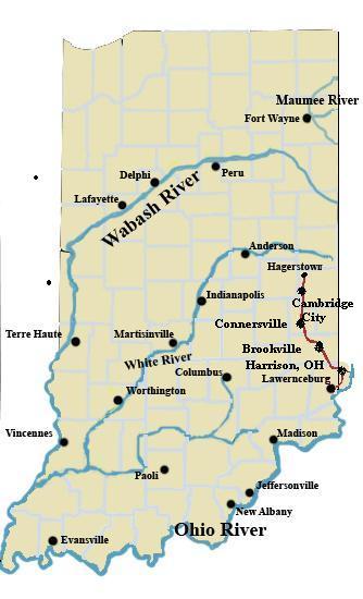
 A map showing the course of the Whitewater Canal
As with most transportation improvements during the nineteenth century, industry paved the way. After successful canal development projects further east in the United States, it would not be long until canals would soon be dug across the Midwest. The opening of the Erie Canal in 1825 paved the way for improvement projects across the United States and changed the course of American transportation history. The Erie Canal was an immediate financial success. This really set the precedent for future canals and proved canals could provide a viable contribution to local economies.
Amidst all of this there was the need for a high-speed transportation system that could link the Whitewater Valley to the Ohio River. Before the canal, farmers had to transport their goods and livestock to Cincinnati, Ohio on badly rutted and often impassable roads. The journey to Cincinnati could take several days.[1]
In 1836 the Indiana State Legislature approved the Mammoth Internal Improvement Act, which allowed for the development of the Whitewater Canal and a host of other improvements throughout Indiana.
Construction
The Whitewater Canal was built based on a 1834 survey conducted by Charles Hutchens.[2] The design called for a canal seventy six miles long starting at Nettle Creek near Hagerstown and following the river valley through Connersville, Brookville and into Harrison, Ohio, then back into Indiana to finish at Lawrenceburg. In the 76 miles (122 km) the canal dropped 491 feet (150 m). This a very ambitious route as it was quite steep and required the crossing of the Whitewater over an aqueduct at Laurel as well as several other streams of lesser size. The 491-foot (150 m) drop compares the Erie Canal which dropped 500 feet (150 m) but did so in 300 miles (480 km). The Wabash & Erie Canal dropped 450 feet (140 m) in 460 miles (740 km) while the Chesapeake & Ohio dropped 538 feet (164 m) in 184 miles (296 km). That meant that the Whitewater descended 6.4 feet per mile compared to the Chesapeake & Ohio at 2.9 feet per mile, the Erie at 1.7 feet per mile and the Wabash & Erie at 1 foot per mile. The steepness became a problem whenever heavy rains came.
Because of the steep grade the canal required 56 locks and seven dams.
The canal was started as a state project and ground was broken on September 13, 1836. The first boat arrived in Brookville from Lawrenceburg on June 8, 1839. Because of budget problems construction was suspended in August 1839 not to be resumed until 1842.[3]
In 1842 the state of Indiana transferred it's ownership in the canal to the White Water Valley Canal Company which was required to complete the canal to Cambridge City in five years. By 1843 boats were arriving in Laurel. 1845 saw the canal operating into Connersville. The canal company was running out of money and borrowed from Henry Valette of Cincinnati to finish the canal into Cambridge City from Connersville. From Cambridge City to Hagerstown the Canal was built by the Hagerstown Canal Company and was finished in 1847.[3]
Canal decline
The Whitewater Canal was a short venture, but it left a lasting mark on the communities it traveled through. The canal development project was funded under the Act of 1836 and was allotted $1,400,000 to build the canal through the Whitewater Valley. This was a huge sum at the time and investors did not take out many loans due to the prediction that they stood to make considerable profit.[1] In fact it was the Mammoth Internal Improvement Act of 1836 that ended up straining the coffers of the State of Indiana. Indiana went bankrupt during the summer of 1839. Therefore, canal construction was halted till 1842.[1]
In November 1847 the Whitewater Valley flooded and many sections of the canal were washed out. The section between Harrison and Lawrenceburg was never rebuilt. This effectively ended the canal era in Lawrenceburg after only eight years of service, and only a few months after the canal was finished to Hagerstown. It was ten months before the canal was again operational north of Harrison. Debt incurred to finance repairs in 1847 were a serious problem for the rest of the canals active history.[3]
White Water Valley Canal Company
The White Water Valley Canal Company was granted a charter by the Indiana General Assembly of 1825-26.[4] The company was set up after the State of Indiana could no longer afford to finish the Whitewater Canal system. The White Water Valley Canal Company finished the canal through Cambridge City, Indiana.
Hagerstown Canal Company
Hagerstown was supposed to be the northern most terminus of the Whitewater Canal, but after the state went bankrupt, Hagerstown was forced to finance and construct its own canal to Cambridge City. The Hagerstown Canal Company completed an eight-mile (13 km) long canal between Hagerstown and Cambridge City in 1847.[1]
Cincinnati And Whitewater Canal
A connecting canal was built to reach Cincinnati, The Cincinnati and Whitewater Canal. This canal was built by Ohio interests and went from Harrison to Cincinnati. It was completed in 1843 and replaced Lawrenceburg as the end of the line after the 1847 November flood. This stretch of canal closed in 1862 and was used as a railroad right-of-way at that time.[3]
The Whitewater Canal today
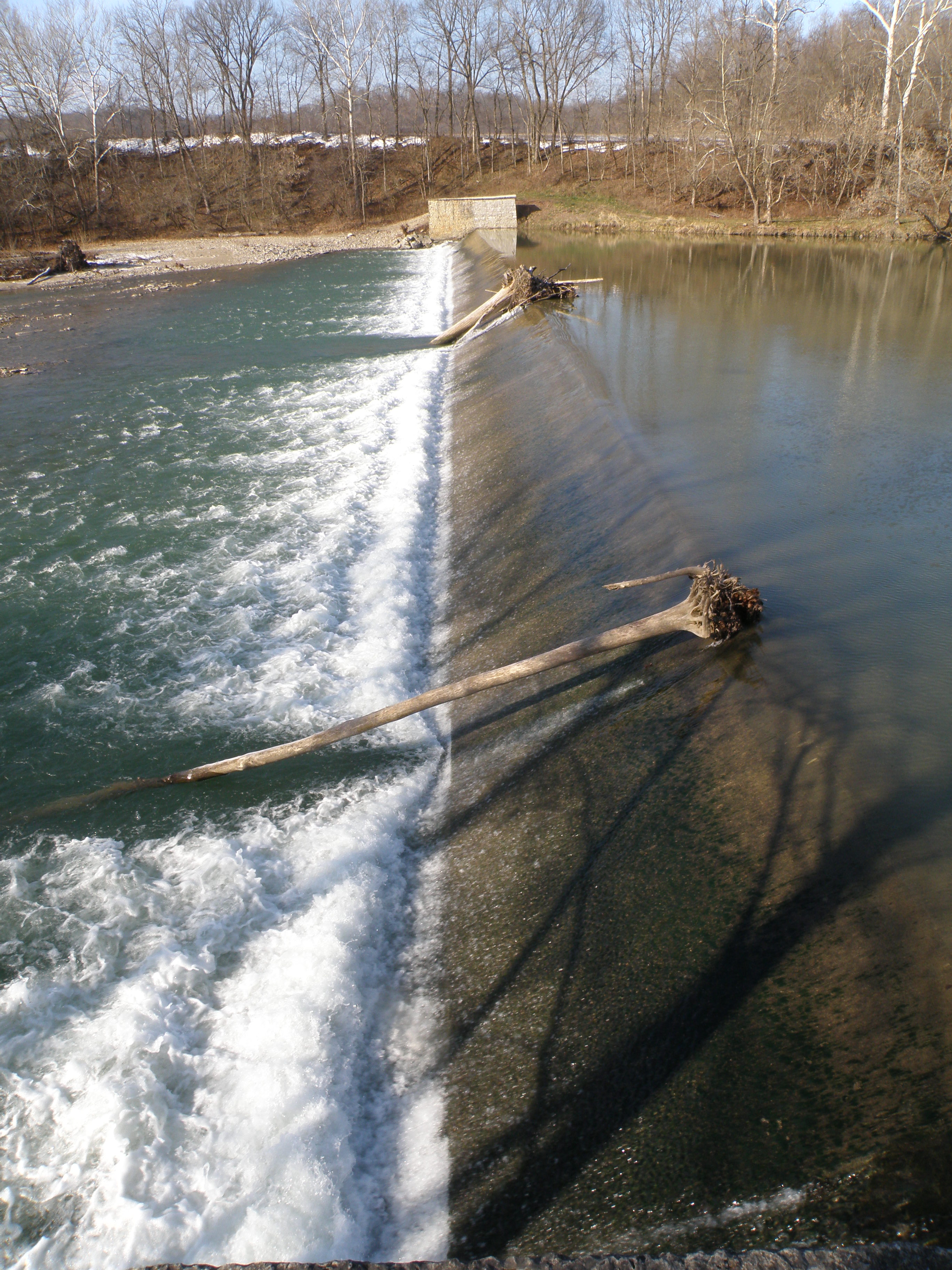
Little is left of the Whitewater Canal today. Some towpath was bought by the Whitewater Valley Railroad Company and has been used in various train operations over the years. A section of the rail line is still in use as a tourist railroad. The Whitewater Valley Railroad operates between Connersville, Indiana and Metamora, Indiana. The remains of many of the canal locks on this section of the canal can still be seen as well as the diversion dam near Laurel, Indiana that was rebuilt in the 1940's and provides water for the restored canal section in Metamora as well as the mill.The restored grain mill in Metamora which runs on water provided by the canal shows that transportation was not the only use of the canal. Hydro power was in use for many decades after the canal was closed as a transportation route and even was used to generate electricity in Connersville in the early part of the 20th century.
The most visible area of the Whitewater Canal that exists today is in Metamora. Here the Canal Era is recreated and tourists can stroll through a nineteenth century town. There are museums, shopping, eateries, and you can even take a horse drawn ride on the canal.
Civil Engineering Landmark status
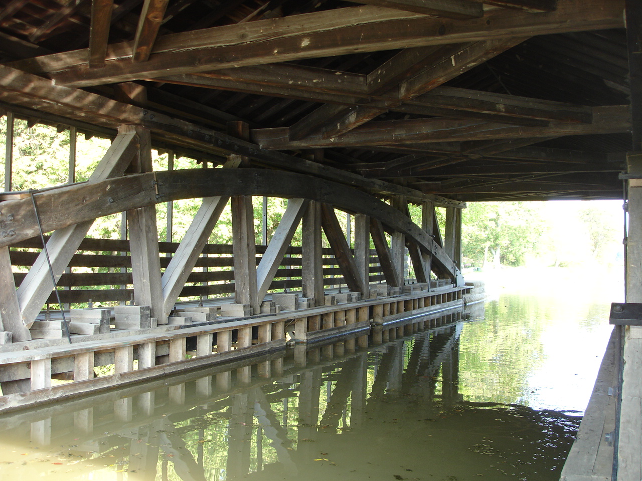
An aqueduct carries the canal over Duck Creek at Metamora. It is the oldest covered wooden aqueduct in the United States, and was listed as a National Civil Engineering Landmark by the American Society of Civil Engineers (ASCE) in 1992.[5]
Towns along the canal
- Cincinnati, Ohio - by way of Cincinnati and Whitewater Canal and Ohio River
- Harrison, Ohio
- Lawrenceburg, Indiana
- Brookville, Indiana
- Metamora, Indiana
- Laurel, Indiana
- Connersville, Indiana
- Milton, Indiana
- Cambridge City, Indiana
- Hagerstown, Indiana
Gallery
-

Duck Creek Aqueduct
-
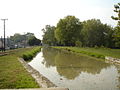
Canal near Duck Creek Aqueduct
-

Canal near Metamora, Indiana
-

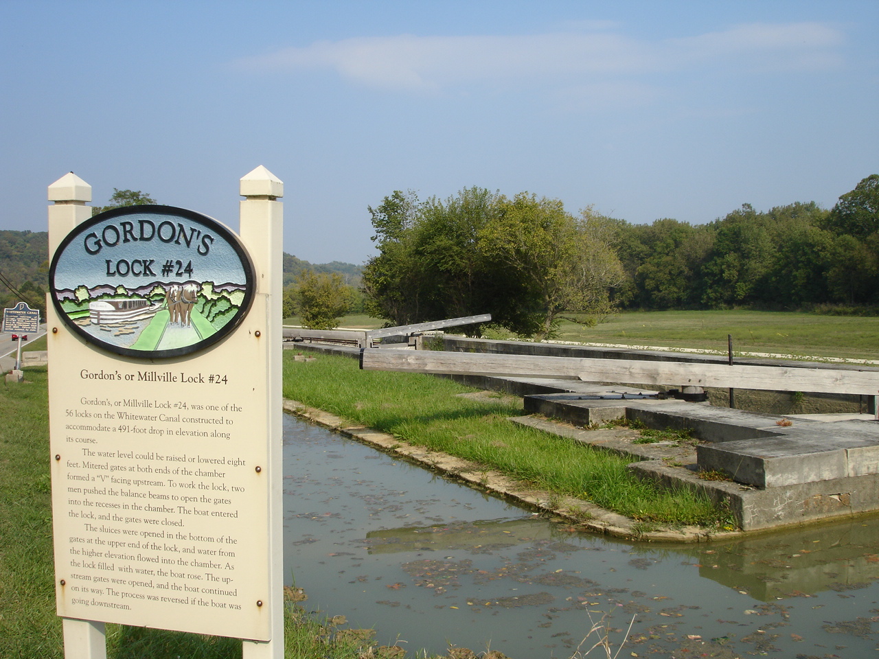
Gordons Lock
-
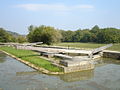
Gordons Lock
-
Gordons Lock
-

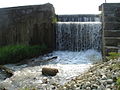
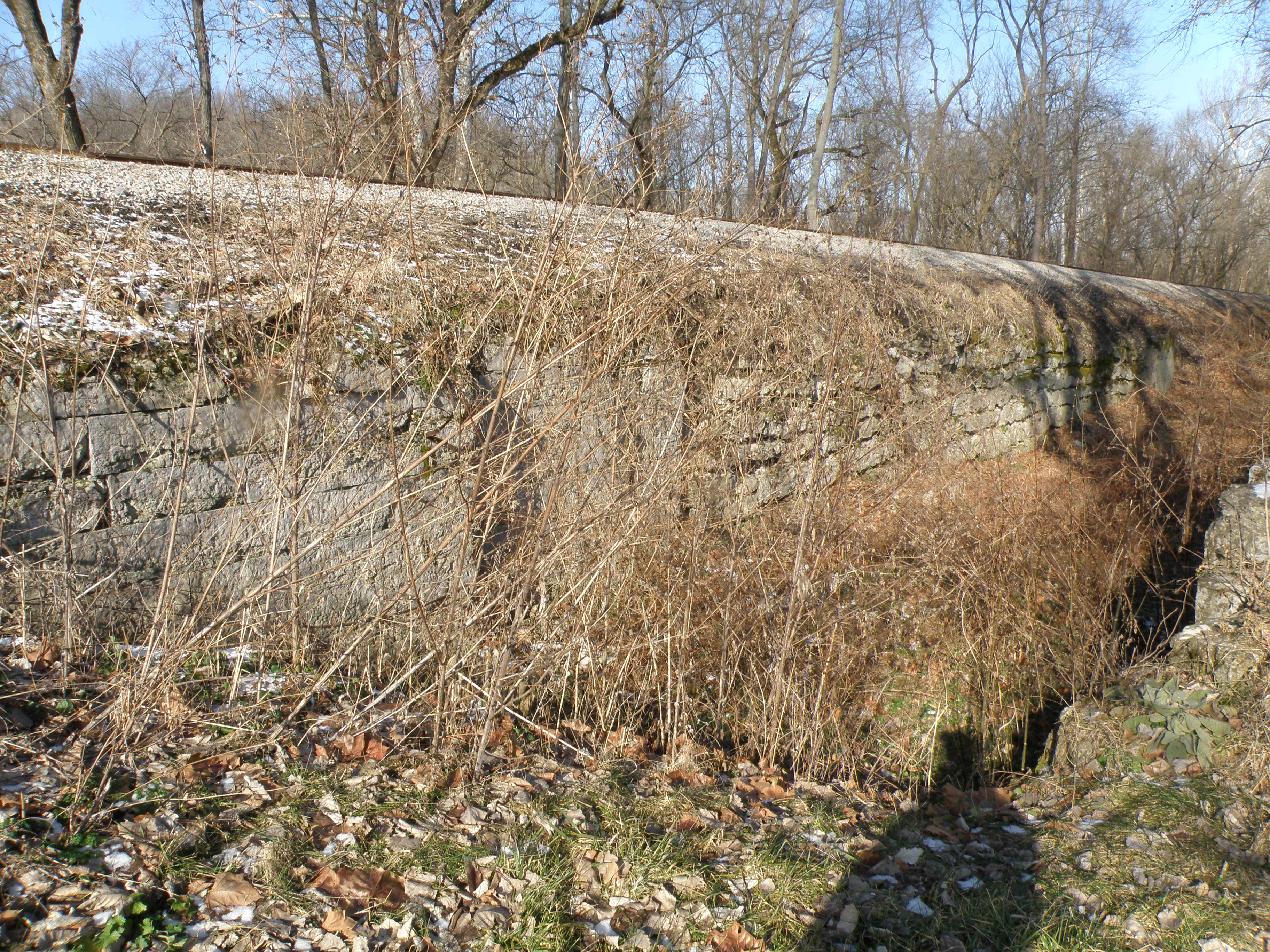
Jenks Lock Ruins at Laurel Dam
-

Diversion dam at Laurel
See also
- Canal
- List of canals in the United States
- List of State Historic Sites in Indiana
- Whitewater Valley Railroad
- Wabash and Erie Canal
- Indiana Central Canal
- Indiana Mammoth Improvement Act
External links
- Canal Map - Link with Map (link may be broken)
- Canal Construction in Indiana - The Indiana Historian, September 1997
- Canal Society of Indiana
- White Water Valley Railroad
- Cincinnati and Whitewater Canal
References
- ^ a b c d Donald Burden, Whitewater Canal Historical Corridor Guide. Ball State. May 2006
- ^ James M. Miller, The Whitewater Canal. Indiana Magazine of History. March 1907, pp 109
- ^ a b c d Paul Fatout, Canalling in The Whitewater Valley. Indiana Magazine of History. March 1964, pp 37 - 78
- ^ Traces and Trails: Intersections of Wayne County. DVD V.Ball Center and Ball State, Muncie, Indiana 2004
- ^ ASCE CE Landmarks list
- Chris Gullion "Whitewater Valley Canal" Report. Ball State. December 2006
Coordinates: 39°27′07″N 85°06′46″W / 39.45194°N 85.11278°W
Categories:- Canals in Indiana
- Transportation in Dearborn County, Indiana
- Transportation in Franklin County, Indiana
- History of Cincinnati, Ohio
- National Road
- Transportation in Union County, Indiana
- Transportation in Wayne County, Indiana


Wikimedia Foundation. 2010.