- List of numbered roads in York Region
-
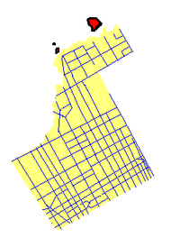 York Regional Road's distributions in all of York Region.
 A sample of York Regional Roads shield.
 A sample of York Regional Roads signs.
York Region, located in southwestern Ontario, assigned approximately 50 regional roads, each with a number ranging from 1 to 99. All expenses of York Regional Roads (for example, snow shoveling, road repairs, traffic lights) are funded by the York Region government.
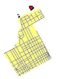
Boundaries of York Region
- Steeles Avenue marks the York Region / City of Toronto Boundary
- York-Durham Regional Road 30 (York-Durham Line) and York Regional Road 32 (Ravenshoe Road) mark the York Region / Durham Region boundary
- York Regional Road 24 (or Peel Regional Road 50) marks the York Region / Peel Region boundary
- Highway 9 and Holland River form the York Region / Simcoe County boundary
Regional Roads
Regional road # Local Name Western/Northern terminus Eastern/Southern terminus Municipality(ies) within York Region Additional notes/Traffic 
Yonge Street York Region / Simcoe County boundary Steeles Avenue Markham, Vaughan, Richmond Hill, Aurora, Newmarket, East Gwillimbury Very busy road with a lot of traffic (especially in Richmond Hill, Thornhill, and Toronto). Viva Blue runs on Yonge Street. 
Kennedy Road Lake Drive East in Georgina Steeles Avenue Markham, Stouffville, East Gwillimbury, Georgina Former sections of Kennedy before the present alignment include Old Kennedy Road, Fresno Circuit, and Main Street Unionville. 
Eagle Street
Water Street
Gorham StreetYonge Street Leslie Street Newmarket One of Newmarket's busiest residential roads. Crosses the north end of Fairy Lake in Newmarket. Transferred to Newmarket. 
Keele Street King Road Steeles Avenue Vaughan, King Sometimes referred to as 4th Concession Road 
Highway 7 York Region / Peel Region Boundary Main Street Markham Vaughan, Richmond Hill, Markham This route is a very heavily travelled route, especially between Highway 400 and McCowan Road in Vaughan, Richmond Hill, and Markham. Most of Viva Purple and Viva Pink run on Highway 7. This route was part of Ontario Highway 7 before the 1997 downloadings. 
Woodbine Avenue Lake Drive North in Georgina Steeles Avenue Markham, Stouffville, Georgina Intersection of Woodbine Avenue and Elgin Mills Road was realigned. The Woodbine By-Pass opened on November 15, 2010.[1][2] 
Baseline Road Woodbine Avenue Dalton Road Georgina The road as an undersigned York Regional Road number #88, which makes it the second highest numbered York Regional Road.[3] 
Dalton Road Lake Drive North Baseline Road Georgina (Sutton) It passes through the heart of Sutton 
King Road York Region / Peel Region Boundary Yonge Street Richmond Hill, King It passes through King City, Nobleton and Oak Ridges 
Don Mills Road
Leslie Street
The Queensway SouthMetro Road South / Morton Avenue Steeles Avenue Markham, Richmond Hill, Aurora, Newmarket, East Gwillimbury, Georgina Famous for its recent blooming of commercial and industrial areas in Richmond Hill 
Mount Albert Road
Bradford Street
Yonge StreetHolland Landing Road York-Durham Line East Gwillimbury Connects Holland Landing, Sharon and Mount Albert 
Stouffville Road
Main Street StouffvilleYonge Street York-Durham Line Richmond Hill, Stouffville It passes through the heart of Gormley and Stouffville. It is one of the busiest rural roads in York Region. 
Wellington Street
Aurora RoadDufferin Street York-Durham Line King Aurora, Whitchurch-Stouffville Pass through the centre of Aurora. The Aurora GO train station can also be found on this road. 
Lloydtown-Aurora Road
Jane Street
18th SideroadHighway 27 Bathurst Street King (Community of Lloydtown) Accessible to Highway 400, links Aurora and Lloydtown 
Islington Avenue Major MacKenzie Drive Steeles Avenue Vaughan Because this road is along the Humber River, this road is very steep at times and contains a lot of curves 
Park Road Hedge Road in Georgina Ravenshoe Road Georgina The road passes through Sibbald Point Provincial Park, and accessible to Highway 48 
Green Lane Bathurst Street Woodbine Avenue East Gwillimbury Highway 404's terminus is at Green Lane (until its future extension is complete), and because of that, traffic is very busy between Yonge Street and Highway 404 
Pefferlaw Road Highway 48 Lake Ridge Road (York Region / Durham Region Boundary) Georgina Passes through the heart of Pefferlaw 
Highway 50 Peel Regional Road 14 (Mayfield Road) Steeles Avenue Vaughan Forms the boundary between York Region and Peel Region. Most often referred to as Peel Regional Road 50, although the road lies in York Region geographically until Peel Regional Road 14. 
Major MacKenzie Drive York Region/Peel Region boundary York-Durham Line Vaughan, Richmond Hill, Markham Formerly a rural road, but urban sprawl in Markham and Vaughan has turned this road into somewhat of an urban thoroughfare. Named after Major Addison Alexander Mackenzie, a former provincial politician and World War I veteran.[4] 
St. John's Sideroad Bathurst Street Woodbine Avenue Aurora, Stouffville No access to Highway 404 
Highway 27 Highway 9 or York Region / Simcoe County boundary Steeles Avenue Vaughan, King Formerly Highway 27 (referred to as Highway 27 in Toronto, and Simcoe County Road 27 in Simcoe County) 
Gamble Road
19th AvenueBathurst Street Leslie Street Richmond Hill, Markham 
York-Durham Line (Also Durham Regional Road 30) Queensville Sideroad in East Gwillimbury Steeles Avenue Markham, Stouffville, East Gwillimbury Separates Durham Region and York Region 
Davis Drive (Formerly Provincial Highway 9) Jane Street York-Durham Region boundary Newmarket, East Gwillimbury, Stouffville One of the busiest rural roads in York Region, separates East Gwillimbury and Whitchurch-Stouffville. Road is still referred to as Davis Drive east into Durham Region 
Ravenshoe Road Holland River at a dead end Lakeridge Road (Durham Regional Road 23) Georgina Runs from southeast of Keswick to Udora. 
Glenwoods Avenue The Queensway South Woodbine Avenue Georgina 
Bayview Avenue
Prospect StreetDavis Drive Steeles Avenue Markham, Richmond Hill, Aurora, Newmarket Very busy with a lot of traffic especially in Markham and Richmond Hill. In Newmarket, a handful of York Region's government buildings can be found. 
Bathurst Street Holland Marsh at a dead end Steeles Avenue Vaughan, King, Newmarket The road was interrupted by the natural landscape in King 
Bloomington Road Bathurst Street York-Durham Line Richmond Hill, Stouffville Formerly Highway 47, one of the busiest rural roads in York Region 
Doane Road Yonge Street Woodbine Avenue East Gwillimbury Runs from Holland Landing to south of Queensville. 
Donald Cousens Parkway Major MacKenzie Drive Highway 407 Markham The road is newly constructed, and therefore the terminus could change in a year-to-year basis. Furthermore, the road is for trucks that have now been banned from Main Street Markham. Formerly called Markham Bypass, the road is now named after the former mayor of Markham, Donald Cousens. 
Elgin Mills Road
Teston Road
Nashville RoadYork Region / Peel Region Boundary Woodbine Avenue Vaughan, Richmond Hill, Markham York Regional Road status was interrupted between Highway 27 and Pine Valley Drive, and also between Keele Street and Dufferin Street. 
Yonge Street Queensville Sideroad Yonge Street East Gwillimbury The road passes through the heart of Holland Landing and serves as an extension of Yonge Street 
Dufferin Street Lloydtown-Aurora Road / 18th Sideroad Steeles Avenue King, Vaughan Sometimes referred to as 3rd Concession Road 
Jane Street Highway 9 Steeles Avenue King, Vaughan Sometimes referred to as 5th Concession Road 
Weston Road Highway 9 Steeles Avenue King, Vaughan Sometimes referred to as 6th Concession Road 
Pine Valley Drive Teston Road Steeles Avenue Vaughan Pine Valley Drive's York Regional Road status was interrupted between Langstaff Road and Rutherford Road 
Warden Avenue Ravenshoe Road Steeles Avenue Markham, Stouffville, East Gwillimbury Passes through the heart of the developing Downtown Markham and is being widened to 6 lanes from Steeles to Apple Creek Drive to accommodate the anticipated traffic it will bring. Traffic frequently jams up between Apple Creek and Highway 7 due to the amount of traffic lights on that stretch. 
McCowan Road Bloomington Road Steeles Avenue Markham, Stouffville Passes through Markville Mall in Markham and is the temporary eastern terminus for Viva Purple. This road also jams up frequently between Highway 407 and Bullock Drive, due to Markville Mall and the amount of traffic lights in the area. 
Markham Road
Main Street MarkhamHighway 407 Steeles Avenue Markham Formerly Highway 48, the road becomes Highway 48 after 16th Avenue 
Ninth Line Aurora Road Steeles Avenue Markham, Stouffville Was at once considered for an expressway. 9th Line borders Cornell and is now changing from a rural road to somewhat of an urban thoroughfare due to urban sprawl, especially in Cornell 
14th Avenue
Centre StreetHighway 7 York-Durham Line Markham, Vaughan York Regional Road status interrupted between Warden Avenue and Bathurst Street. The original road, however, is linked by Alden Road, John Street and Esna Park Drive, but they are not recognized officially as York Regional Road 71. 
Langstaff Road York Region / Peel Region boundary Highway 7 Vaughan The road is interrupted twice. The first time is between Keele Street and Jane Street because of the CN rail yard. The second time is between Islington Avenue and Highwya 27 because of the Humber River. 
16th Avenue
Carrville Road
Rutherford RoadYork Region/Peel Region boundary York-Durham Line Vaughan, Richmond Hill, Markham One of the busiest roads in York Region. It is often packed during the rush hour periods between Kennedy Road and Warden Avenue in Markham. 
Mulock Drive
Vivian DriveBathurst Street York-Durham Line Newmarket, Stouffville 
Main Street (Schomberg) Highway 9 Highway 27 King 
Queensville Sideroad Bathurst Street Woodbine Avenue East Gwillimbury Connects River Drive Park, Holland Landing and Queensville. 
Metro Road
Morton AvenueWoodbine Avenue Dalton Road Georgina Built on the former railway of the Toronto and York Radial Railway, it passes through the heart of the community of Keswick 
Old Homestead Road
Station RoadMetro Road North Pufferlaw Road Georgina 
Black River Road Dalton Road Park Road Georgina Named after Black River in Jackson's Point, Ontario 
Weir's Sideroad Old Homestead Road Ravenshoe Road Georgina 
Victoria Road Ravenshoe Road Lake Ridge Road (York Region / Durham Region Boundary) Georgina 
Holland Landing Road Yonge Street Toll Road East Gwillimbury 99 Highway 427 Zenway Boulevard Highway 7 Vaughan York Region built "extension" of Highway 427. Regional Road 99 will be bypassed and subsequently removed with the pending northerly extension of Highway 427. References
- ^ Woodbine Avenue Bypass to Open in Town of Markham
- ^ http://www.york.ca/NR/rdonlyres/5vpf4moqi5qxo5hf4nwt7kk63exzz6dk4vdgy4xsanqyerta7loo46jqwxiopsxlfm2rcm6gpi6fyeh5m4rh32xeid/rpt+2+cls+3.pdf
- ^ "List of York Regional Roads and their class". http://yorkexplorer.york.ca/yorkexplorer/pdf/2006_TrafficVolumes_Sml.pdf. Retrieved 2007-09-15.[dead link]
- ^ York University Archives
- MapArt Golden Horseshoe atlas Pages 300-399
Regional Roads in York Region, Ontario North-south East-west Roads in Ontario Numbered roads in Ontario County roads Brant · Bruce · Dufferin · Elgin · Essex · Frontenac · Grey · Haliburton · Hastings · Huron · Lambton · Lanark · Leeds and Grenville · Lennox and Addington · Middlesex · Norfolk · Northumberland · Oxford · Perth · Peterborough · Prescott and Russell · Prince Edward · Renfrew · Simcoe · Stormont, Dundas and Glengarry · WellingtonRegional roads Municipal roads See also County roads in Ontario · Ontario numbered highways · Expressways and 400-series highways · King's Highways · Secondary highways · Tertiary and 7000-series highways · List of Ontario provincial highways · List of former provincial highways in Ontario · Highways in Ontario · List of Ontario expressways · Trans-Canada Highway · Connecting Link · Emergency Detour Route Categories:- York Regional Roads
- Lists of roads in Ontario


Wikimedia Foundation. 2010.