- List of numbered roads in Waterloo Region
-
The following is a list of numbered roads in the Regional Municipality of Waterloo, Ontario. Numbered roads are maintained by the Waterloo Region Transportation Department.
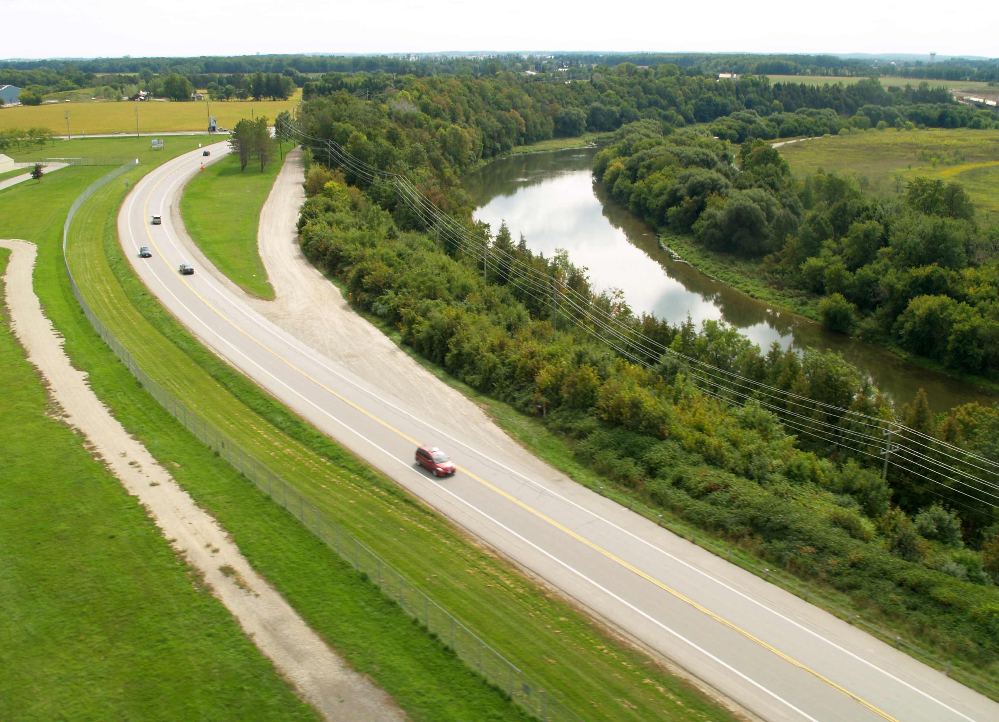
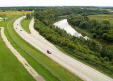 Waterloo Regional Road 17 (Fountain Street) facing south alongside the Grand River
Contents
Table of numbered roads
County Road # Local Name(s) Northern/Western Terminus Southern/Eastern Terminus Settlements served Additional Notes 1 Waterloo Street
Huron StreetConcession Road Sandhills Road New Hamburg, Baden 3 Walker Road King's Highway 7 & 8 Oxford-Waterloo Road none minor rural route 4 Peel Street
Bleams Road
Ottawa StreetRegional Road 1 Regional Road 54 New Hamburg, Mannheim, Kitchener 5 Manser Road
William Hastings Line
Hutchison Road
Queen's Bush Road
Nafziger RoadRegional Road 86 King's Highway 7 & 8 Wellesley, Linwood 6 Snyders Road
Highland RoadRegional Road 51 King's Highway 85 Baden, Kitchener 7 Hutchison Road Regional Road 5 Road 105 Wellesley 8 King Street
Weber StreetRegional Road 17 Highway 401 St. Jacobs, Waterloo, Kitchener 9 Erb's Road
Erb Street
Bridgeport RoadRoad 101 Regional Road 52 St. Agatha, Waterloo, Bridgeport 10 Herrgott Road Regional Road 86 Regional Road 15 St. Clements, Wallenstein 11 William Hastings Line Road 116 Regional Road 5 none minor rural route 12 Gerber Road
Notre Dame Drive
Queen Street
New Dundee RoadRegional Road 5 Regional Road 28 Wellesley, St. Agatha, New Dundee, Doon 14 Weimar Line
Moser-Young RoadRegional Road 12 Regional Road 16 Bamberg 15 Lobsinger Line
King StreetRegional Road 5 Regional Road 55 St. Clements, Heidelberg 16 Kressler Road
Erbsville Road
Ira Needles BoulevardRegional Road 17 Regional Road 9 Heidelberg, Erbsville, Waterloo 17 Fountain Street
Ebycrest Road
Hawkesville Road
Ament LineRegional Road 5 King's Highway 8 St. Jacobs, Conestogo, Bloomingdale, Breslau, Cambridge 19 Floradale Road Ruggle's Road Regional Road 86 Floradale 20 Bloomingdale Road Regional Road 52 Regional Road 17 Bridgeport 21 Arthur Street Floradale Road Regional Road 85 Elmira, North Woolwich 22 Northfield Drive Wellington County limits Regional Road 8 Waterloo, Conestogo 23 Katherine Street Woolwich-Pilkington Townline Regional Road 17 Winterbourne, Zuber Corners 24 Hespeler Road Wellington County limits King's Highway 8 Glenchristie, Cambridge 26 St. Charles Street
Maryhill RoadRegional Road 17 Woolwich-Guelph Townline Maryhill, Bloomingdale 27 Clyde Road
Samuelson Street
Beverly StreetKing's Highway 24 Village Road Cambridge, Clyde 28 Homer Watson Boulevard
Fountain StreetRegional Road 4 King's Highway 8 Cambridge, Doon, Kitchener 29 Lancaster Street Regional Road 52 Regional Road 55 Kitchener, Bridgeport 30 Shantz Station Road Regional Road 26 Regional Road 31 Kossuth 31 Kossuth Road Regional Road 17 Regional Road 24 Kossuth 33 Townline Road Wellington County Road 34 Gore Road Cambridge 36 Franklin Boulevard Regional Road 39 Regional Road 43 Cambridge 38 Sportsworld Drive
Maple Grove RoadRegional Road 8 Regional Road 24 Kitchener 39 Eagle Street
Pinebush RoadKing's Highway 8 Regional Road 33 Cambridge 41 Bishop Street King's Highway 8 Regional Road 36 Cambridge 42 Blair Road
George StreetRegional Road 28 Regional Road 97 Cambridge 43 Myers Road
Branchton RoadKing's Highway 24 Brant County Road 144 Cambridge, Littles Corners, Branchton 45 East River Road King's Highway 24 Brant County limits Lockie 46 Roseville Road Regional Road 58 Cambridge city limits Roseville, Orrs Lake shares roadway with Regional Road 71 between Dickie Settlement Road and Edworthy Sideroad 47 Dumfries Road Regional Road 46 Regional Road 75 Wrigley 49 Wrigley Road Regional Road 58 Regional Road 47 Wrigley, Ayr 50 Westmount Road Regional Road 8 Regional Road 58 Kitchener, Waterloo 51 Foundry Street Regional Road 1 Regional Road 4 Baden, Wilmot Centre 52 Bridge Street Regional Road 22 Regional Road 17 Waterloo, Bridgeport 53 Courtland Avenue
Fairway RoadRegional Road 6 Regional Road 54 Kitchener 54 Lackmer Boulevard King's Highway 7 Regional Road 53 Kitchener 55 Victoria Street Regional Road 70 King's Highway 85 Kitchener 56 Bleams Road Regional Road 70 Regional Road 69 Kitchener 57 University Avenue Glasgow Street Regional Road 52 Waterloo 58 Bearinger Road
Fisher-Hallman Road
Roseville Road
Northumberland Street
Swan StreetRegional Road 50 Brant-Waterloo Road Waterloo, Kitchener, Roseville, Ayr 61 Bruce Street Regional Road 55 Regional Road 56 Kitchener 62 Edna Street Regional Road 55 Regional Road 56 Kitchener 64 Charles Street Regional Road 55 Regional Road 4 Kitchener 69 Manitou Drive Regional Road 53 Regional Road 28 Kitchener 70 Ira Needles Boulevard
Trussler RoadRegional Road 55 Regional Road 97 Kitchener, Mannheim, Plumtree 71 Dickie Settlement Road
Roseville Road
Edworthy SideroadRegional Road 28 Regional Road 97 none minor rural route; shares roadway with Regional Road 71 along Roseville Road 75 Spragues Road
St. Andrews StreetRegional Road 42 Brant-Waterloo Road Cambridge 80 Can-Amera Parkway King's Highway 24 Regional Road 33 Cambridge 85 Listowel Road
Arthur Street SouthRegional Road 86 Regional Road 15 none Waterloo-Elmira rural route 86 Line 86 Red Woods Drive Sideroad 16 Macton, Wallenstein, Elmira, Zuber Corners, Weissenburg 97 Cedar Creek Road
Cedar Street
Concession Street
Main Street
Old Beverly RoadRegional Road 70 Hamilton city (old Wentworth County) limits Cambridge -
This list is incomplete; you can help by expanding it.
Waterloo Regional Road 4
Waterloo Regional Road 4 is an arterial road located in the Region of Waterloo, Ontario, Canada. It is a major east-west thoroughfare through the city of Kitchener, where it is known as Ottawa Street. Despite running east-west, Ottawa Street is labeled north-south, with King Street being the dividing line. Upon passing Trussler Road westward out of Kitchener and entering Wilmot Township, Waterloo Regional Road 4 is renamed Bleams Road.
In Kitchener, Ottawa Street intersects the Conestoga Parkway at two points. However, only the first intersection on Ottawa Street North (between the Freeport Diversion and Highway 7) is served by a full signed interchange. The second intersection, on Ottawa Street South west of the Freeport Diversion, must be accessed via the Homer Watson Boulevard interchange.
Three major shopping centres are located along its route. Stanley Park Mall is situated on Ottawa Street North at the intersection with River Road. Ottawa Street South is the home of two power centres: the Sunrise Shopping Centre is located at the intersection with Fischer-Hallman Road, while the Laurentian Power Centre is at the intersection with Homer Watson Boulevard. Ottawa Street South is also the site of the Concordia Club, a major festhalle which hosts up to 4,000 revelers during Oktoberfest each year.
Waterloo Regional Road 6
Waterloo Regional Road 6 is an east-west arterial road in the Region of Waterloo, Ontario, Canada. It passes through both Wilmot Township and the city of Kitchener, with its course and name changing several times.
Wilmot Township
Waterloo Regional Road 6 begins at Waterloo Regional Road 51 (Foundry Street) in the village of Baden, where it is known as Gingerich Road. Travelling northeastward, it merges with Waterloo Regional Road 1 at the eastern edge of the village and takes the name of Waterloo Regional Road 1 within Baden, Snyder's Road East. From this junction its course changes east heading towards Kitchener, passing through the village of Petersburg along the way.
Kitchener
Upon entering Kitchener, Waterloo Regional Road 6 takes the name Highland Road and becomes a major thoroughfare through the western half of the city. It has major intersections with Waterloo Regional Road 58 (Fischer-Hallman Road) and Waterloo Regional Road 50 (Westmount Road) before meeting with Queen Street South near St. Mary's General Hospital.
From here, Waterloo Regional Road 6 turns left onto Queen Street South and enters downtown Kitchener. At Waterloo Regional Road 53 (Courtland Avenue), it turns right and briefly has a concurrency with R.R. 53 before turning left onto Benton Street, which is the heart of the city's Oktoberfest celebrations each year.
At Waterloo Regional Road 15 (King Street), Benton Street becomes Frederick Street; it is here that the headquarters of the Regional Municipality of Waterloo are located, as well as several provincial court houses and the Frederick Mall. After passing Waterloo Regional Road 56 (River Road), Frederick Street curves northeastward again, before it (as well as Waterloo Regional Road 6) ends at Waterloo Regional Road 55 (Victoria Street), also known as Highway 7, which continues eastward to Guelph.
Waterloo Regional Road 10
Waterloo Regional Road 10 is an arterial road located in the Region of Waterloo, Ontario, Canada. It is a major north-south thoroughfare through the from Wallenstein, Ontario(Line 86) to St. Clements, Ontario(Lobsinger Line), where it is known as Herrgott Road.
Waterloo Regional Road 10 also use to run from Lobsinger Line to Weimer Line, along Moser Young Road. This has since been downloaded to the Township.
Waterloo Regional Road 15
Main article: Waterloo Regional Road 15
Waterloo Regional Road 15, or King Street is the major north-south arterial road in Kitchener, Ontario, as well as Waterloo, Ontario. In both Kitchener and Waterloo, King Street divides the city into the east and west sides. King Street "resumes" in southern Kitchener and continues to Cambridge, Ontario.
Waterloo Regional Road 39
Waterloo Regional Road 39 is an arterial road in the Region of Waterloo, Ontario, Canada. It runs entirely within the city of Cambridge, just south of Highway 401.
Regional Road 39 begins in the Preston section of Cambridge at Highway 8, where it is known as Eagle Street North. Eagle Street runs a somewhat hilly course and intersects with three railway lines before leveling out, where car dealerships begin to line its northern edge.
At the junction with Highway 24, Eagle Street changes its name to Pinebush Road. It is here that a large Home Depot store (which used to be a Knob Hill Farms supermarket) is located, as well as a shopping centre containing a Wal-Mart, among other things. After its intersection with Waterloo Regional Road 36, better known as Franklin Boulevard, Pinebush Road enters an industrial area, through which it traverses before ending at Waterloo Regional Road 33 (Townline Road), just west of Puslinch Lake.
Waterloo Regional Road 57
Waterloo Regional Road 57, also known as University Avenue, is an east-west arterial road located in Waterloo, Ontario, Canada. It gets its name from the two major institutions of higher education, Wilfrid Laurier University and the University of Waterloo, that are situated along its route.
Route description
University Avenue begins at Northfield Drive in the northeastern corner of the city. From there it curves southward, paralleling the Grand River before turning west again prior to the intersection with Bridge Street. After an interchange with the Conestoga Parkway, it goes on to meet many of the major north-south arterial roads of Waterloo. The campus of Wilfrid Laurier University is just past the intersection with King Street, and the University of Waterloo campus can be found between Albert Street and Westmount Road.
After passing the University of Waterloo, University Avenue turns southwest to meet Erb Street (another major east-west road in Waterloo), then curves west again to meet Fischer-Hallman Road. It ends at a roundabout at Ira Needles Boulevard on the western edge of the city.
University Avenue's circuitous routing creates the unique situation of being parts of both the northern and southern municipal boundaries of the City of Waterloo.
Major intersections including University Avenue
- Northfield Drive
- Lexington Road
- Bridge Street
- Conestoga Parkway (a Parclo AB4 interchange)
- Weber Street
- Regina Street
- King Street
- Albert Street
- Westmount Road
- Erb Street
- Fischer-Hallman Road
- Ira Needles Boulevard (a modern roundabout)
Waterloo Regional Road 69
Waterloo Regional Road 69, or Manitou Drive is a north-south road in the southern part of the city of Kitchener, Ontario, Canada.
Manitou Drive begins at Fairway Road and Courtland Avenue; the Manitou Drive intersection delineates Fairway Road from Courtland Avenue.
From this intersection, Manitou runs southward, passing through mainly industrial areas, including an intersection with Bleams Road. (Plans to extend Bleams Road easterly to Wilson Ave and the planned River Road extension may include converting this intersection to a roundabout.)
Homer Watson Boulevard is Manitou Drive's southern terminus, although the street itself continues beyond Homer Watson as Doon Village Road, the main artery of Kitchener's Pioneer Park neighbourhood.
Regional Roads in Waterloo Region, Ontario North-South Regional Roads East-West Regional Roads Highways and Expressways Numbered roads in Ontario County roads Brant · Bruce · Dufferin · Elgin · Essex · Frontenac · Grey · Haliburton · Hastings · Huron · Lambton · Lanark · Leeds and Grenville · Lennox and Addington · Middlesex · Norfolk · Northumberland · Oxford · Perth · Peterborough · Prescott and Russell · Prince Edward · Renfrew · Simcoe · Stormont, Dundas and Glengarry · WellingtonRegional roads Municipal roads See also County roads in Ontario · Ontario numbered highways · Expressways and 400-series highways · King's Highways · Secondary highways · Tertiary and 7000-series highways · List of Ontario provincial highways · List of former provincial highways in Ontario · Highways in Ontario · List of Ontario expressways · Trans-Canada Highway · Connecting Link · Emergency Detour RouteCategories:- Roads in Waterloo Region, Ontario
-
Wikimedia Foundation. 2010.