- April 1957 Dallas tornado outbreak
-
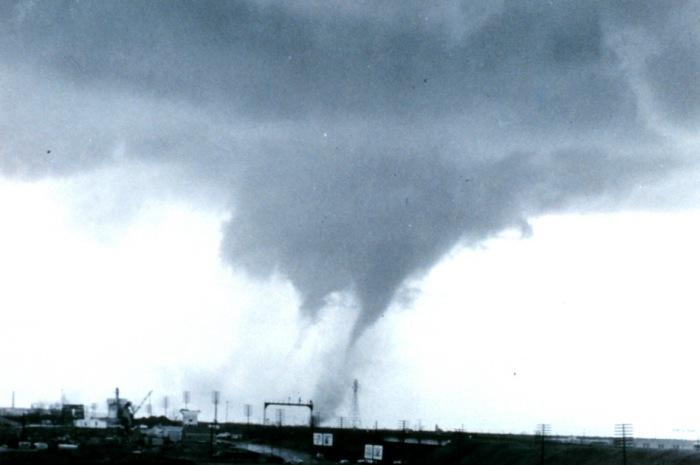
April 1957 Dallas tornado outbreak The 1957 Dallas tornado with multiple vortices observed at the time as it approaches the city
Date of tornado outbreak: April 2–4, 1957 Duration1: ~2 days Maximum rated tornado2: F4 tornado Tornadoes caused: 50 Damages: unknown Fatalities: 19 Areas affected: Southern United States 1Time from first tornado to last tornado
2Most severe tornado damage; see Fujita ScaleThe April 1957 Dallas tornado outbreak was a deadly tornado outbreak that struck most of the Southern United States from April 2 to the early hours of April 4, 1957. The outbreak was most notable due to a tornado that hit a densely populated area of the Dallas Metropolitan area, while other deadly tornadoes struck portions of Mississippi, Texas, and Oklahoma. The two-day outbreak killed at least 19 across 3 states and produced 50 tornadoes from Texas to Tennessee.
Contents
Meteorological synopsis
On April 2, a low pressure system was situated over the Texas and Oklahoma panhandles with a warm front stretching into central Arkansas and a cold front stretching into western Texas east of El Paso, Lubbock, and Amarillo.[1] Temperatures on that day reached the 70s in northern Texas with dewpoints in the upper 60s to near 70 degrees Fahrenheit. A strong upper level jet, abundant instability in the atmosphere, and substantial wind shear provided additional fuel for the development of supercellular storms across the region.[2]
The Dallas tornado
Outbreak death toll State Total County County
totalMississippi 1 Smith 1 Oklahoma 6 Bryan 3 Marshall 2 Murray 1 Texas 12 Dallas 10 Delta 1 Lamar 1 Totals 19 All deaths were tornado-related At around 3:00 PM CST, the first tornadoes touched down north of the Dallas-Fort Worth Metroplex area. At around 4:30 CST, a tornado touched down in southern Dallas County (south of modern-day Interstate 20) and traveled northward for about 45 minutes through the Dallas neighborhoods of Oak Cliff, Kessler Park, West Dallas (just west of Downtown Dallas) and Love Field before lifting over Bachman Lake (west of Dallas Love Field Airport) just after 5:00 PM CST. Ten people were killed and 200 others injured by the F3 tornado; damage was estimated at around $4 million (in 1957 dollars). Nearly 600 structures were damaged including over 100 homes and a dozen apartment buildings.[3] Some businesses and schools were also damaged but the Parkland Memorial Hospital was narrowly spared by the tornado as was the Dallas Love Field Airport. Another tornado in Collin County north of the city also caused extensive damage.
The tornado was heavily documented and photographed by several eye-witnesses as it was clearly visible throughout most of its 17-mile path through residential and commercial areas of Dallas up to near Love Field Airport. At that time, it was the most observed tornado ever. A researcher from the Severe Weather Forecast Unit in Kansas City noticed that several old theories were proven false during the Dallas tornado. One of the theories was that all air and debris flow inward into the funnel and then upward, but on the outside edges of the funnel debris and people were even lifted.[3] WFAA-TV in Dallas produced a 30-minute documentary about the tornado about one week later.[4]
Another major tornado event struck the densely populated areas of the Dallas–Fort Worth Metroplex on March 28, 2000 when F3 tornadoes struck Downtown Fort Worth as well as Arlington killing at least 3 and injuring dozens of people while damaging or destroying several structures including several office towers. Additional tornadoes that touched down near the Metroplex area the following morning in Fort Worth and other areas but no additional fatalities were reported.
Other tornadoes
Other killer tornadoes touched down in Lamar and Delta Counties in Texas, Marshall, Bryan and Murray Counties in Oklahoma and Smith County in Mississippi. 5 of the fatalities in Oklahoma were from the 2 F4 tornadoes that occurred during the outbreak. The activity shifted further east into the southern Mississippi River Valley as well as the Tennessee Valley on April 3 and the early hours of April 4 before activity ceased.
Tornado table
Confirmed
TotalConfirmed
F0Confirmed
F1Confirmed
F2Confirmed
F3Confirmed
F4Confirmed
F550 14 10 18 6 2 0 Confirmed tornadoes
April 2, 1957 event
F# Location County Time (UTC) Path length Damage Texas F2 SE of Howe Grayson 2100 0.1 miles
(0.16 km)F2 south west of Spanish Fort Montague 2125 2 miles
(3.2 km)F0 NE of Grapevine Tarrant 2150 0.3 miles
(0.5 km)F0 S of Pottsboro Grayson 2200 0.1 miles
(0.16 km)F3 W of Melissa to Van Alstyne Collin, Grayson 2220 10.7 miles
(17.1 km)F3 Oak Cliff to W of Oldham Dallas 2230 17.2 miles
(27.5 km)10 deaths F2 W of Roxton Lamar 0000 6.5 miles
(10.4 km)1 death F2 N of Wheeler Wheeler 0005 0.3 miles
(0.5 km)F3 NE of Briar Wise 0015 0.1 miles
(0.16 km)F0 NE of Stony Denton, Cooke 0030 1.5 miles
(2.4 km)F2 SE of Harmon Lamar 0030 0.1 miles
(0.16 km)F2 E of Noble Delta 0151 0.1 miles
(0.16 km)1 death F0 Terrell area Kaufman 0715 0.1 miles
(0.16 km)Oklahoma F1 W of Healdton Jefferson 2130 2 miles
(3.2 km)F2 W of Dolberg Murray, Garvin 2250 11.7 miles
(18.7 km)F2 W of Dougherty Murray 2255 2 miles
(3.2 km)1 death F4 S of Aylesworth Marshall 2329 5.2 miles
(8.3 km)2 deaths F4 Durant area Bryan 2358 7.9 miles
(12.6 km)3 deaths F2 E of Altus to W of Mountain View Jeackson, Kiowa 0030 43.7 miles
(69.9 km)F0 W of Asher Pottawatomie 0040 0.1 miles
(0.16 km)F0 SW of Friendship Jackson 0105 8.8 miles
(14.1 km)F1 SE of Grant to SE of Spencerville Choctaw 0115 16.8 miles
(26.9 km)F2 W of Benga to McCurtain Latimer, Haskell 0300 23.3 miles
(37.3 km)F2 Haileyville to NW of Patterson Pittsburg 0305 11.7 miles
(18.7 km)F1 NE of Broken Bow McCurtain 0330 11.2 miles
(17.9 km)F0 Poteau area Le Flore 0350 0.1 miles
(0.16 km)F0 The Village area Oklahoma 0430 0.1 miles
(0.16 km)F1 SW of Courtney Love 0545 0.1 miles
(0.16 km)F0 N of Davenport Lincoln 0615 0.1 miles
(0.16 km)Source: Tornado History Project - April 2, 1957 Storm Data April 3, 1957 event
F# Location County Time (UTC) Path length Damage Texas F1 NE of Nesbitt Harrison 1628 0.1 miles
(0.16 km)F0 SE of Krugerville Denton 1630 0.1 miles
(0.16 km)F0 Fort Worth area (S) Tarrant 1645 0.1 miles
(0.16 km)F0 Duncanville area Dallas 1650 0.1 miles
(0.16 km)F2 NE of Cedar Springs Morris 1700 0.1 miles
(0.16 km)F2 SW of Woodlawn Harrison 1730 0.1 miles
(0.16 km)F1 Orange area Orange 1845 0.1 miles
(0.16 km)F2 W of Patroon Shelby 1930 2 miles
(3.2 km)Missouri F1 SE of Caruth Dunklin 1800 1 miles
(1.6 km)F0 E of Dogwood Mississippi 1930 0.3 miles
(0.5 km)Arkansas F2 E of Paragould Greene 1805 0.1 miles
(0.16 km)F3 E of Cash to N of Finch Greene, Craighead 1805 22.6 miles
(36.2 km)F1 W of Little River Mississippi 1830 0.1 miles
(0.16 km)Illinois F2 Cairo area Alexander, Pulaski 2000 6.8 miles
(10.9 km)Kentucky F1 E of Matlock Warren 2330 0.1 miles
(0.16 km)Louisiana F0 N of Jonesboro Jackson 0000 0.5 miles
(0.8 km)Mississippi F2 SW of Hollandale Washington 0115 11.9 miles
(19 km)F2 NE of Vernon to W of Forreston Winston, Noxubee, Lowndes 0615 40.7 miles
(65.1 km)F3 NW of Magee to SW of Penantly Simpson, Smith, Jasper 0700 40.2 miles
(64.3 km)1 death Tennessee F2 SE of Middle Fork Henderson 0710 0.1 miles
(0.16 km)F3 E of Ramer McNairy 0715 7.3 miles
(11.7 km)Source: Tornado History Project - April 3, 1957 Storm Data Tornado History Project - April 4, 1957 Storm Data See also
References
External links
Categories:- F4 tornadoes
- Tornadoes of 1957
- Tornadoes in Texas
- Tornadoes in Oklahoma
- Tornadoes in Mississippi
- 1957 in the United States
Wikimedia Foundation. 2010.