- Cortes, Aberdeenshire
-
Coordinates: 57°37′23″N 1°59′28″W / 57.623°N 1.991°W
Cortes 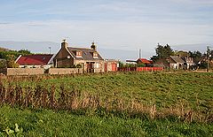
Cortiebrae Cottages, Cortes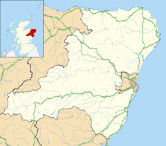
 Cortes
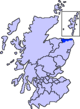
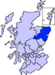
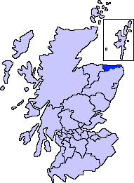
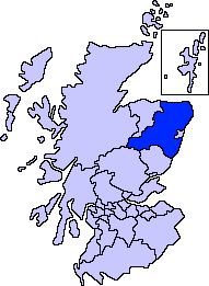
Cortes shown within AberdeenshireOS grid reference NK006592 Council area Aberdeenshire Country Scotland Sovereign state United Kingdom Post town FRASERBURGH Postcode district AB43 Dialling code 01346 (Lonmay) Police Grampian Fire Grampian Ambulance Scottish EU Parliament Scotland UK Parliament Banff and Buchan Scottish Parliament Banff and Buchan List of places: UK • Scotland • Cortes is a rural settlement in the Banff and Buchan area of Aberdeenshire, Scotland, situated in the parish of Rathen, 7.8 kilometres (4.8 mi) south of Fraserburgh.[1]
The area stretches from the grounds of Cortes House in the west to Cortes Village in the east on the border with the adjacent parish of Lonmay.
Contents
Schools
Primary education is provided at Rathen School,[2] whilst secondary pupils travel to Fraserburgh Academy.
Transport
Cortes lies at the northern end of the A952 road at its junction with the A90 road.
Regular bus services connect the area to Fraserburgh, Peterhead and Aberdeen, and an on-demand Dial-a-bus service is also available.[3]
The nearby Lonmay railway station closed in 1979, and now offers an access point to the Formartine and Buchan Way, the long-distance path that follows the route of the former railway.
Landmarks
To the south lies Mormond Hill, on the slopes of which a hill figure known as the White Stag of Mormond, marked with quartz stones, was first laid out by Mr F. W. Cordiner of Cortes to mark his wedding in 1870.[4]
History
The name Cortes is said to derive from a Gaelic word meaning circle, in reference to a structure that was described as a Druid temple in the New Statistical Account of Scotland (1845),[5] but is now believed to be the remains of a recumbent stone circle.[6]
Another stone circle, of which only three stones remain, is situated on farmland at Cortie Brae.[7]
Cortes House is a granite-built Regency mansion, built in 1810.[8]
References
- ^ "Cortes: Description". Scotland's Places. http://www.scotlandsplaces.gov.uk/search/index.php?action=do_search&id=2831&p_name=CORTES&p_type=POPULATED_PLACE&p_parish1=Rathen. Retrieved 7 January 2010.
- ^ "Rathen Primary School". Rathen School. http://www.rathen.aberdeenshire.sch.uk/. Retrieved 7 January 2010.
- ^ "Public transport information". Aberdeenshire Council. http://www.aberdeenshire.gov.uk/publictransport/index.asp. Retrieved 7 January 2010.
- ^ "White Horse and Stag on Mormond Hill". Peterhead and Buchan Tourism Initiative. http://www.buchanonline.co.uk/visitpeterhead/index.php?option=com_content&view=article&id=261%3Awhite-horse-and-stag-on-mormond-hill&catid=54%3Ageneral&Itemid=86. Retrieved 7 January 2010.
- ^ "The New Statistical Account of Scotland (1845), Volume XII, Aberdeen: Parish of Rathen". Electric Scotland. http://www.electricscotland.com/hiStory/statistical/rathen.htm. Retrieved 7 January 2010.
- ^ "Cortes: Archaeological Notes". Scotland's Places. http://www.scotlandsplaces.gov.uk/search_item/index.php?service=RCAHMS&id=20703. Retrieved 7 January 2010.
- ^ "Cortie Brae". Scotland's Places. http://www.scotlandsplaces.gov.uk/search_item/index.php?service=RCAHMS&id=21098. Retrieved 7 January 2010.
- ^ "Cortes House". Cottages and Castles. http://www.scottish-castle-holidays.co.uk/aberdeen-deeside/cortes.htm. Retrieved 7 January 2010.
Settlements and places of interest in Banff and Buchan, Aberdeenshire Primary settlements Aberchirder · Banff · Fraserburgh · Gardenstown · Inverallochy and Cairnbulg · Macduff · Portsoy · Rosehearty · Sandhaven · Whitehills
Other settlements Boyndie · Broadsea · Cornhill · Cortes · Crovie · Fordyce · King Edward · Memsie · Netherbrae · New Aberdour · New Byth · Pennan · Sandend
Places of interest Areas and primary settlements in Aberdeenshire
(see also: Aberdeen City)in Banff and Buchan Aberchirder · Banff · Fraserburgh · Gardenstown · Inverallochy and Cairnbulg · Macduff · Portsoy · Rosehearty · Sandhaven · Whitehills
in Buchan Boddam · Crimond · Cruden Bay · Fetterangus · Hatton · Longside · Maud · Mintlaw · New Deer · New Pitsligo · Peterhead · St Combs · St Fergus · Strichen · Stuartfield
in Formartine Balmedie · Cuminestown · Ellon · Fyvie · Newburgh · Oldmeldrum · Pitmedden · Potterton · Rothienorman · Tarves · Turriff
in Garioch in Kincardine and Mearns Drumoak · Fettercairn · Gourdon · Inverbervie · Johnshaven · Laurencekirk · Newtonhill · Portlethen · St Cyrus · Stonehaven
in Marr Categories:- Villages in Aberdeenshire
- Aberdeenshire geography stubs


Wikimedia Foundation. 2010.