Mormond Hill

Mormond Hill
Mormond Hill and its antenna
Aerial masts on Mormond Hill

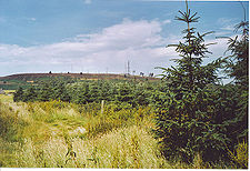
Mormond Hill (from the Gaelic --mor-- meaning big and --monadh--for hill) is a large hill in Aberdeenshire, Scotland not far from Fraserburgh. The villages of Strichen and New Leeds can be found at its foot hills.

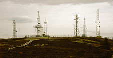
It also has a smattering of disused satellite dishes and masts on top, remnants from Cold War NATO communications and British Telecom having a presence on the site.

The hill is mentioned in the traditional Scottish ballad known as Mormond Braes.[1] The word 'Brae' is held to mean 'hill' in Scottish Gaelic, while the rest of the ballad is a mix of English and Scots, with references to 'Strichen toon'. The ballad is about a girl who's lost her lover and is preparing herself to face the world and get another.


The White Horse and the White Deer (Stag)

A white horse is depicted on the side of the hill made from white quartz that has been placed into position to make the shape. It is a war memorial to a Sergeant who gave up his horse for his Captain in battle.

The white deer (also known as 'The white stag') was created in a similar way, with quartz on the side of the hill but was made as a wedding present rather than as a memorial.

Unusually, these are the only two hill figures located in Scotland. There are three more in Wales and roughly 50 more in England. The White Horse is one of sixteen horses in the United Kingdom, whilst the stag is one of two stags in the United Kingdom, although the other is more of a natural figure which simply looks like one.

References

External links

General Information-

Satellite Dish Information-

Coordinates: 57°36′N 2°04′W / 57.6°N 2.067°W / 57.6; -2.067


Wikimedia Foundation. 2010.

Игры ⚽ Поможем написать реферат

Look at other dictionaries:

  • Hill figure — The Long Man of Wilmington situated on the South Downs, Sussex A hill figure is a large visual representation created by cutting into a steep hillside and revealing the underlying geology. It is a type of geoglyph usually designed to be seen from …   Wikipedia

  • Mormond —    MORMOND, a village, in the parish of Strichen, county of Aberdeen, 1¼ mile (N. N. E.) from Strichen; containing 681 inhabitants. This place takes its name from the adjacent hill of Mormond, an eminence rising to the height of 800 feet above… …   A Topographical dictionary of Scotland

  • New Leeds — Coordinates: 57°34′55″N 2°00′29″W / 57.582°N 2.008°W / 57.582; 2.008 …   Wikipedia

  • Cortes, Aberdeenshire — Coordinates: 57°37′23″N 1°59′28″W / 57.623°N 1.991°W / 57.623; 1.991 …   Wikipedia

  • ACE High — Station auf Lefkada im Sonnenaufgang ACE High war ein Kommunikationssystem der NATO im Kalten Krieg. Das System reichte von Norwegen bis in die Türkei. Dabei wurden mit Parabolantennen gerichtete UHF Aussendungen hoher Leistung an der Troposphäre …   Deutsch Wikipedia

  • Mintlaw Academy — Motto Putting learning first Established 1981 Type State comprehensive …   Wikipedia

  • New Pitsligo — Church of Scotland kirk in New Pitsligo New Pitsligo is a village in Aberdeenshire, Scotland, quite near Peterhead.[1]. Locals often refer to the village by the name Cyaak …   Wikipedia

  • Deer, New —    DEER, NEW, a parish, in the district of Deer, county of Aberdeen, 6 miles (E. S. E.) from Cuminestown; containing, with the village of Kirktown of New Deer, 3756 inhabitants. This parish originally formed a part of Old Deer, and was separated… …   A Topographical dictionary of Scotland

  • Tropospheric scatter — (or troposcatter) is the scattering of distant TV and FM radio stations by the troposphere so that they travel farther than the line of sight. This effect sometimes allows reception of stations up to a hundred miles away.The phenomenon has been… …   Wikipedia

  • Crimond — Coordinates: 57°36′04″N 1°54′50″W / 57.601°N 1.914°W / 57.601; 1.914 …   Wikipedia

Share the article and excerpts

Direct link
Do a right-click on the link above
and select “Copy Link”