- Communities in Norfolk County, Ontario
-
Norfolk County in the Canadian province of Ontario is founded on the very communities that form its core. The long list of communities that are found on a typical map of Norfolk County include: Atherton, Bill's Corners, Booth's Harbour, Bealton, Blayney, Bloomsburg, Boston, Carholme, Clear Creek, Courtland, Cultus, Delhi, Fairground, Fernlea, Fishers Glen, Forestville, Frogmore, Gilbertville, Glenshee, Glen Meyer, Green's Corners, Halfway House Corners, Hartford, Hemlock, Hillcrest, Houghton Centre, King Lake, Langton, La Salette, Long Point, Lynedoch, Lynnville, Nixon, Normandale, Pine Grove, Port Dover, Port Rowan, Port Royal, Port Ryerse, Powells Corners, Rattlesnake Harbour, Renton, Rhineland, Silver Hill, Simcoe, South Middleton, St. Williams, Teeterville, Turkey Point, Ungers Corners, Vanessa, Villa Nova, Vittoria, Walsh, Walsingham, Waterford, Wilsonville, Windham Centre and Wyecombe.
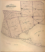 Map of Norfolk County from 1877, showing historical townships.
However, the most notable communities in Norfolk County, Ontario are Delhi (shown in map), St. Williams (slightly east of Port Rowan), Port Dover (shown in map), Simcoe (shown in map), Waterford (shown in map), Courtland (west of Delhi), Gilbertville (south of Delhi), Lynedoch (southwest of Delhi) and Hillcrest (west of Simcoe).
Contents
Communities
Port Dover
Main article: Port Dover, OntarioIn 1670, French missionaries François Dollier de Casson and René Bréhant de Galinée became the first Europeans to winter at what is now modern day Port Dover. Earthen remains and a plaque mark the spot near the fork of the Lynn River (Patterson's Creek to many older Port Doverites) and Black Creek where they and seven Frenchmen built a hut and chapel.
By 1794 the first settlers, a group of United Empire Loyalists, had established a hamlet known as Dover Mills (named for the English port of Dover) which was razed to the ground by the Americans in the War of 1812. Subsequent reconstruction took place closer to the mouth of the Lynn River, where a harbour had been in use since the early 19th century. In 1835, merchant Israel Wood Powell registered a village plan for Port Dover. Improvement to the harbour during the next fifteen years made Port Dover a principal Lake Erie port. Shipyards, tanneries, and Andrew Thompson's woollen-mill contributed substantially to local economic growth. In 1879, Port Dover became an incorporated village with a population of 1,100.
Port Dover in the 20th century became a fishing village and tourist destination. Port Dover's fishing industry at one time hosted the largest freshwater fishing fleet in the world that employed many of the town’s citizens and continues to be important to the community. From 1906 to 1993, the town was home to Thomas A. Ivey and Sons, one of Canada's largest wholesale florists and rose-growers, and Port Dover's largest employer. In 1974, Port Dover was incorporated as Ward 2 of the former city of Nanticoke.
 Willie's Restaurant in Port Dover on Friday, August 13, 2004.
In the summer, Port Dover is busy with thousands of tourists who come to swim in Lake Erie and enjoy the town and surrounding area. Port Dover’s business district is dominated by small shops that cater to the tourist trade with many bars and restaurants that depend largely on the increased traffic during the summer months. One of the most traditional businesses is The Arbor that sells cherry glows instead of soft drinks and hot dogs served on thick pieces of hot dogs buns in addition to French fries.
The Port Dover Yacht Club has occupied land purchased from W.F. Kolbe and Co. at the fork of the Lynn River and Black Creek since September 1938. The P.D.Y.C. welcomes visitors every summer from around the Great Lakes region and beyond.
Port Dover has celebrated Canada Day with a parade every year since July 1867. The day starts off with the annual Soap-box Derby, the Boat Parade at the harbour, a Calithumpian Parade down Main Street and a fireworks display after dark.
Since 1981, there has been a tradition of motorcycle enthusiasts gathering in the town for Friday the 13th. Chris Simons and approximately 25 friends, through word of mouth, got together at the old Commercial Hotel. It was in November and it was Friday the 13th. They decided they should do it every Friday the 13th. On June 13, 2008 an estimated 150,000 bikers and spectators converged on Port Dover for Friday the 13th.
Simcoe
Simcoe is the administrative centre of Norfolk County, with a population of 16,000 making it Norfolk's largest community. Simcoe is located at the junction of Highway 3, at Highway 24, due south of Brantford, Ontario, and accessible to Hamilton by nearby Highway 6. The town is northwest of Nanticoke in Haldimand County.
Simcoe was founded in 1795 by Lieutenant Governor John Graves Simcoe.[1] The town hosts a Friendship Festival, the Norfolk County Fair and Horse Show, and a Christmas Panorama of Lights.[1]
From the 19th century to early 2000, Simcoe had its own town council and mayor.
Waterford
Waterford sits on the old Canada Southern Railroad, preceding various other rail company takeovers, the latest of which was by CN/CP. The now idle line passes through Ontario between Buffalo, New York and Detroit, Michigan. Norfolk FS (formerly known as the Norfolk Co-Operative) also holds a major base of operations here, which provide chemicals, dangerous goods, and feed to local farmers.
The area surrounding the town is primarily agricultural land, with tomatoes, tobacco and corn among the chief crops. Other natural health and organic crops are being explored, such as ginseng, but area farmers are generally suffering from the decline of the tobacco industry. In 1979, a freak tornado swept through Waterford, devastating trees, homes, and public property.
St. Williams
St. Williams is a small hamlet and fishing community in Norfolk County, Ontario Canada. The lakeside community is located 30 minutes south of Pine Grove. St. Williams is about 30 minutes from both Simcoe and Tillsonburg. It is a village with a population of approximately 400 people. Backus Mill is located close by and it is popularized as being one of the only mills left standing after the War of 1812. Tourists can enjoy Backus, just outside of St. Williams on the way to Port Rowan, all year round with hiking, sledding, camping and discovering the history of the mill.
A railroad line once passed through St. Williams but was decommissioned in the 1990s. Their public school was closed in the early first decade of the 21st century and their grocery store became a mini-mart. There was also an old folks' home that was shut down and the old fire hall also an antiquated building in St. Thomas.
Hillcrest
Hillcrest is a hamlet in Norfolk County, Ontario, Canada that is in between Bill's Corners and the town of Simcoe. Agriculture is the main industry and commerce includes a furniture store and a video rental store. The nearest elementary school is Elgin Avenue Public School, the nearest secular high school is Simcoe Composite School, and the nearest faith-based high school is Holy Trinity Catholic High School.
The hamlet is located southeast of Nixon and northwest of Port Dover and is centered around Hillcrest Road which is the site of the former Norfolk Board of Education building. Hillcrest is also the home of a charity which helps people acquire wheelchairs called the Who Did It Club which was founded by war veterans and is currently maintained by civilian volunteers from the local area. The hamlet and all land that is within 2 miles to the south are also considered to be prime land for the possible further expansion of the town of Simcoe. Within 30–60 years, Hillcrest and Simcoe may overlap each other as pristine tobacco farms are foreclosed and sold to developers. Eventually, all land used for tobacco farms will become houses, stores, restauarants, factories, and other businesses.
There is also a soccer field. Youth leagues generally use the field for its state of the art bleachers and close proximity to residential neighborhoods. Adult amateur leagues typically do not use this field and the community is neither large nor wealthy enough to support a professional or a semi-professional soccer team. The field is generally used in the spring and summer. Use of the soccer field by individuals and families is possible in the fall. However, the local climate prevents its use from November to mid April due to snow.
Courtland
Courtland is a village located in Norfolk County, Ontario, Canada on Highway 3 between Delhi and Tillsonburg. To the west of the town is a motorcycle shop and a gas station that was once owned by the Norfolk Co-Operative and now belongs to a rival agriculture corporation.
North Street is the oldest street in the village which runs parallel with the railroad tracks. There are five churches in the village, the oldest being the Lutheran Church. Main Street is the street that has the most commerce and Highway Crescent offers a passageway from the highway for the local residents. In the eastern part of the village, a cul-de-sac community called Talbot Court is being constructed. The current mayor is Dennis Travale.
There are few stores in the village. Examples of commerce includes variety store with a golf course that closed on October 16, 2003 along with an antique store, a breakfast house, and the old Ozzie's Car Mart.
Gilbertvile
Gilbertville (population approx. 20 people) is a hamlet in Norfolk County, Ontario, Canada that is in between Pine Grove and Delhi. The local economy is founded on agriculture, which produces potatoes, onions, and asparagus, among other vegetables. Commerce in Gilbertville includes a grocery store, a tractor shop, and an auto repair shop. There is a conservation park to the west of the hamlet. For administrative purposes and municipal elections, Gilbertville is considered to be the southernmost community in the third ward of Norfolk County.
The founding fathers of Gilbertville all had the last name Gilbert. The hamlet was founded in the 19th century as a hitching stop between Simcoe and Delhi, along with nearby Atherton to the east. During the early 20th century, there is a defunct military base in Gilbertville that is being used for alternative purposes. Since the defunct military base is considered to be private property, it is assumed to be used for civilian purposes. Prior to the 21st century, sulphur water was present in Gilbertville, causing a swamp-like stench. The problem eventually disappeared c. 2002 due to advances in irrigation technology.
There are no plans for expansion of any kind in Gilbertville. The population has remained relatively the same for more than 50 years. Property taxes are low. Any children who reside in Gilbertville attend Delhi Public School for their elementary education. Secondary education is provided by Delhi District Secondary School for students in the secular system while Holy Trinity Catholic High School in Simcoe provides the secondary school education for students in the Roman Catholic education system.
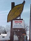
Delhi
Delhi (pronounced DEL-High), originally 'Fredericksburg', is located off of the junction of Hwy 59 and 3 and is known as the Heart of Tobacco Country.[2] Until 2001, Delhi was located within the Township of Delhi, a municipal government within the Regional Municipality of Haldimand-Norfolk. Prior to the amalgamation of Norfolk County, the population of the former Township of Delhi was 16,365 in the Canada 2001 Census[3]
Part of the agricultural heritage of Delhi included tobacco[2] cultivation. The town has a tobacco museum to commemorate this part of its history. Local farms rely in part upon Jamaican and Mexican workers, who usually arrive around mid-to late April and return to their homelands around early-to-mid November.
Delhi is a multicultural community, though the majority of those cultures are of European descent. Community halls exist for those of Belgian, German, Polish and Hungarian background. The population also includes those of Dutch, Portuguese, Greek, Ukrainian, Lithuanian, and British background.
The local high school, Delhi District Secondary School has faced the threat of closure in the past, but the local school board has committed to keeping the school open for the indefinite future.[4] The local elementary school, Delhi Public School, serves children from nearby hamlets like nearby La Salette. Saint Frances Cabrini Catholic School is also located in Delhi and is part of the Brant Haldimand Norfolk Catholic District School Board.
Delhi is home to the Delhi Travellers, a junior hockey team that plays in the Southern Ontario Junior Hockey League.
Climate data for Delhi Month Jan Feb Mar Apr May Jun Jul Aug Sep Oct Nov Dec Year Record high °C (°F) 18.3
(64.9)16
(61)25
(77)29.5
(85.1)33
(91)36.7
(98.1)40.6
(105.1)36.7
(98.1)36.1
(97.0)31.7
(89.1)25
(77)19.5
(67.1)40.6
(105.1)Average high °C (°F) −2.1
(28.2)−1.3
(29.7)4.4
(39.9)11.9
(53.4)19.3
(66.7)24.4
(75.9)27
(81)25.7
(78.3)20.9
(69.6)14.2
(57.6)7.2
(45.0)1
(34)12.7 Daily mean °C (°F) −5.7
(21.7)−5.3
(22.5)0
(32)6.6
(43.9)13.2
(55.8)18.4
(65.1)20.9
(69.6)20
(68)15.6
(60.1)9.4
(48.9)3.5
(38.3)−2.5
(27.5)7.8 Average low °C (°F) −9.4
(15.1)−9.4
(15.1)−4.3
(24.3)1.2
(34.2)7.1
(44.8)12.3
(54.1)14.8
(58.6)14.2
(57.6)10.2
(50.4)4.5
(40.1)−0.2
(31.6)−5.9
(21.4)2.9 Record low °C (°F) −33.9
(−29.0)−30
(−22)−25
(−13)−15
(5)−6.1
(21.0)−1.7
(28.9)3.3
(37.9)−0.6
(30.9)−3.9
(25.0)−9.4
(15.1)−18.9
(−2.0)−28
(−18)−33.9
(−29.0)Precipitation mm (inches) 70.1
(2.76)59.2
(2.331)83.1
(3.272)85.3
(3.358)83.6
(3.291)83.2
(3.276)86.1
(3.39)85.8
(3.378)98.1
(3.862)83.9
(3.303)100.1
(3.941)91.3
(3.594)1,009.8
(39.756)Source: Environment Canada[5] Lynedoch
Lynedoch is a hamlet in Norfolk County, Ontario, Canada which was named after Baron Lynedoch who served under Wellington during the War of 1812. Until the Mike Harris cutbacks closed it, Lynedoch had its own public elementary school called Lynedoch Public School. Agriculture is the sole industry in the community and there is virtually no commerce.
The hamlet of Lynedoch also has a community group which is non-profit and consists mostly of residents of Lynedoch. It is located northwest of Pine Grove, southwest of Delhi, and east of Simcoe.
Dog's Nest
Dog's Nest is a community northeast of Port Dover along Highway 6. The Port Dover band "Dog's Nest" and the Simcoe restaurant "Dog's Nest Smokehouse" were both named after the small community.
References
- ^ a b "Southern Ontario Tourism: Simcoe, Ontario". Southern Ontario Tourism Organization. http://www.soto.on.ca/southern_grand_river_country_and_ontario's_south_coast/simcoe.html. Retrieved 2007-12-04.
- ^ a b "Delhi Harvestfest". http://delhiharvestfest.tripod.com/. Retrieved 2007-04-16.
- ^ "Community Highlights for Delhi". 2001 Community Profiles. Statistics Canada. http://www12.statcan.ca/english/profil01/CP01/Details/Page.cfm?Lang=E&Geo1=CSD&Code1=3528049&Geo2=PR&Code2=35&Data=Count&SearchText=Delhi&SearchType=Begins&SearchPR=35&B1=All&Custom=. Retrieved 2007-04-16.
- ^ Hartlen, Vicki (2007-04-04). "Choosing DDSS was right decision, grad says". Delhi News-Record (Bowes Publishers). http://cgi.bowesonline.com/pedro.php?id=302&x=story&xid=298592. Retrieved 2007-04-16.
- ^ Environment Canada [1], accessed 30 April 2010
Categories:


Wikimedia Foundation. 2010.