- Clanfield, Oxfordshire
-
Coordinates: 51°42′58″N 1°35′53″W / 51.716°N 1.598°W
Clanfield 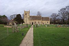
Parish church of Saint Stephen
 Clanfield
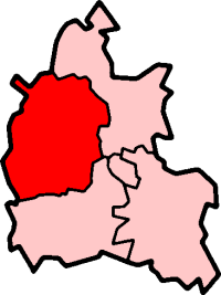
Clanfield shown within OxfordshirePopulation 855 (2001 census)[1] OS grid reference SP2801 Parish Clanfield District West Oxfordshire Shire county Oxfordshire Region South East Country England Sovereign state United Kingdom Post town Bampton Postcode district OX18 Dialling code 01993 Police Thames Valley Fire Oxfordshire Ambulance South Central EU Parliament South East England UK Parliament Witney Website Clanfield Village List of places: UK • England • Oxfordshire Clanfield is a village and civil parish about 3 miles (4.8 km) south of Carterton, Oxfordshire. The parish includes the hamlet of Little Clanfield 1 mile (1.6 km) west of the village, on Little Clanfield Brook which forms the parish's western boundary. The parish's eastern boundary is Black Bourton Brook and its southern boundary is Radcot Cut, an artificial watercourse on the River Thames floodplain. Much of the parish is low-lying and prone to flooding, for example in July 2007.[2]
Contents
History
Robert D'Oyly gave land at Clanfield to the Order of Knights Hospitaller, who built a moated preceptory on the site.[3] This gift must have predated D'Oyly's fall from power in 1142 during the Anarchy.[3] By 1279 the preceptory owned land and property not only at Clanfield but also at Brize Norton, Grafton, Westwell, Oxford and Woodstock.[3] The preceptory buildings have gone and their moated site is now occupied by Friars Court, a gabled house built in about 1650.[4] Friars Court is a private house but it is now hired out as an approved venue for weddings and civil partnerships.[5]
In the Church of England parish church of Saint Stephen the tympanum over the south door is Norman and both the arcade between the nave and the north aisle and the responds of the chancel arch are in the Transitional style between Norman and the Early English Gothic style.[6] These features date the church building to about AD 1200.[6] St. Stephen's has four lancet windows dating from late in the 12th century or early in the 13th century: two in the south wall of the chancel and two in the north wall of a chapel on the north side of the chancel.[6] In the chancel the east window and the easternmost window in the south wall are in the Decorated Gothic style, which dates them to between 1250 and 1350.[6] The style of the bell tower suggests it was built either about 1300 or early in the 14th century.[6] In the 15th century a large statue of St. Stephen was added to the outside of the tower,[7] a squint was inserted in the south side of the chancel and the present font was made.[6] The nave was rebuilt in 1869 and the chancel enlarged and partly rebuilt in 1870.[6] The tower has a peal of eight bells.[8]
The parish had two water mills at Little Clanfield on Little Clanfield Brook. One of them, Little Clanfield Mill, is now a private house but its machinery remains operational.[9]
The road between Witney and Clanfield was a turnpike from 1771 until 1874.[10]
Amenities
The Plough Hotel is a three-bay house[6] built of Cotswold stone in about 1660 that is now a public house.[11] From late in the 19th century until the 1950s it was controlled by Garnes Brewery of Burford.[11] In the 1950s Wadworth Brewery of Devizes bought Garnes and thus the Plough.[11] The Masons Arms public house is also a 17th century Cotswold stone building, recently renamed the Clanfield Tavern.[12]
Clanfield Church of England Primary School was founded in 1873 and enlarged in 1991.[13] The village has a post office and general store. The village's association football club, Clanfield F.C., has its ground in Radcot Road and plays in the Hellenic Football League.[14] Clanfield has a Women's Institute.[15]
References
- ^ "Area selected: West Oxfordshire (Non-Metropolitan District)". Neighbourhood Statistics: Full Dataset View. Office for National Statistics. http://neighbourhood.statistics.gov.uk/dissemination/viewFullDataset.do;jsessionid=ac1f930b30d73ec370d62b6f4444bc01a4cf1c94ffa8?instanceSelection=03070&productId=779&$ph=60_61&datasetInstanceId=3070&startColumn=1&numberOfColumns=8&containerAreaId=790500&nsjs=true&nsck=true&nssvg=true&nswid=1020. Retrieved 24 March 2010.
- ^ Oxford Mail website, 23 July 2007
- ^ a b c Page, 1907, pages 105-106
- ^ Sherwood & Pevsner, 1974, page 547
- ^ Silver Pear Weddings
- ^ a b c d e f g h Sherwood & Pevsner, 1974, page 546
- ^ Sherwood & Pevsner, 1974, pages 545-546
- ^ Oxford Diocesan Guild of Church Bell Ringers, Witney & Woodstock Branch
- ^ Geograph: Little Clanfield Mill, Little Clanfield, Oxfordshire
- ^ Turnpike Roads in England
- ^ a b c History of the Plough: A Potted History
- ^ Welcome to the Clanfield Tavern
- ^ Clanfield CE Primary School: Our School
- ^ Hellenic Football League: Division One (West) League Table
- ^ Oxfordshire Federation of Women's Institutes
Sources and further reading
- Page, William, ed (1907). Victoria County History: A History of the County of Oxford, Volume 2. Archibald Constable & Co. pp. 105–106.
- Sherwood, Jennifer; Pevsner, Nikolaus (1974). The Buildings of England: Oxfordshire. Harmondsworth: Penguin Books. pp. 545–547. ISBN 0 14 071045 0.
- Townley, Simon C. (ed.); Colvin, Christina; Cragoe, Carol; Ortenberg, Veronica; Peberdy, R.B.; Selwyn, Nesta; Williamson, Elizabeth (2006). Victoria County History: A History of the County of Oxford, Volume 15: Bampton Hundred (Part Three). pp. 112–147.
External links
 Media related to Clanfield, Oxfordshire at Wikimedia Commons
Oxfordshire • County Council elections • District Council elections • Witney County Constituency Towns Burford (Signet, Upton) • Carterton • Charlbury • Chipping Norton (Southcombe) • Witney (Cogges, Madley Park) • Woodstock (Hensington, Old Woodstock)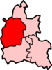
Large Villages Aston, Cote, Shifford and Chimney (Aston, Cote, Shifford, Chimney) • Bampton (Lower Haddon, Weald) • Brize Norton • Ducklington • Enstone (Church Enstone, Neat Enstone, Chalford, Cleveley, Fulwell, Gagingwell, Lidstone, Radford) • Eynsham (Barnard Gate) • Freeland • Hailey (New Yatt) • Hanborough (Church Hanborough, Long Hanborough) • Milton-under-Wychwood • Minster Lovell • North Leigh (East End, Wilcote) • Shipton-under-Wychwood • Standlake (Brighthampton) • Steeple Barton (Middle Barton) • StonesfieldOther Civil
Parishes
(Component
Villages
and Hamlets)Alvescot • Ascott-under-Wychwood (Ascott d'Oyley, Ascott Earl) • Asthall (Asthall Leigh, Worsham) • Black Bourton • Bladon • Blenheim • Broadwell • Bruern • Cassington (Worton) • Chadlington • Chastleton • Chilson (Shorthampton) • Churchill • Clanfield • Combe • Cornbury and Wychwood (Cornbury, Wychwood) • Cornwell • Crawley • Curbridge • Fawler • Fifield • Filkins and Broughton Poggs (Filkins, Broughton Poggs) • Finstock • Fulbrook • Glympton • Grafton and Radcot (Grafton, Radcot) • Great Tew • Hardwick-with-Yelford (Hardwick, Yelford) • Heythrop (Dunthrop) • Holwell • Idbury (Bould, Foscot) • Kelmscott • Kencot • Kiddington with Asterleigh (Asterleigh, Kiddington, Over Kiddington) • Kingham • Langford • Leafield • Lew • Little Faringdon • Little Tew • Lyneham • Northmoor • Over Norton • Ramsden (Mount Skippett) • Rollright (Great Rollright, Little Rollright) • Rousham • Salford • Sandford St. Martin (Ledwell) • Sarsden • Shilton • South Leigh • Spelsbury (Dean, Taston) • Stanton Harcourt • Swerford • Swinbrook and Widford (Swinbrook, Widford) • Tackley • Taynton • Westcott Barton • Westwell • Wootton (Dornford, Hordley) • Worton (Nether Worton, Over Worton)Former Districts
and BoroughsChipping Norton Rural District • Municipal Borough of Chipping Norton • Witney Urban District • Witney Rural District • Municipal Borough of Woodstock • Woodstock Rural DistrictFormer
ConstituenciesList of Parliamentary constituencies in Oxfordshire • List of places in Oxfordshire • List of civil parishes in Oxfordshire Categories:- Villages in Oxfordshire
- Civil parishes in Oxfordshire
- West Oxfordshire


Wikimedia Foundation. 2010.