- Chastleton
-
Coordinates: 51°57′47″N 1°38′31″W / 51.963°N 1.642°W
Chastleton
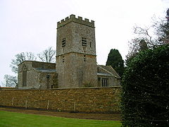
The parish church of St Mary the Virgin
 Chastleton shown within Oxfordshire
Population 121 (2001 census)[1] OS grid reference SP2429 Parish Chastleton District West Oxfordshire Shire county Oxfordshire Region South East Country England Sovereign state United Kingdom Postcode district GL56 Dialling code 01491 Police Thames Valley Fire Oxfordshire Ambulance South Central EU Parliament South East England UK Parliament Witney List of places: UK • England • Oxfordshire Chastleton is a village and civil parish in the Cotswold Hills in Oxfordshire, England, about 4 miles (6.4 km) northeast of Stow-on-the-Wold. Chastleton is in the extreme northwest of Oxfordshire, on the boundaries with both Gloucestershire and Warwickshire.
Contents
History
Chastleton Barrow is an Iron Age hill fort southeast of the village, marked by a ring of mature trees.
The Church of England parish church of Saint Mary the Virgin was built late in the 12th century, was enlarged and refenestrated in the 14th century, and has a south bell tower that was added in 1689.[2] The church is one of five in the parish of Little Compton, which is itself part of the Team Benefice of Chipping Norton, along with the parishes of Chipping Norton with Over Norton, Churchill and Kingham.
Next to the parish church is Chastleton House, one of England's finest and most complete Jacobean houses. Completed in 1612, it has been occupied by members of the Jones family since 1602.[2] It is now owned by the National Trust who opened the property to the public in 1997 after six years of conservation work. The house is full of objects accumulated by the family over the years - rare tapestries, portraits, furniture, as well as personal belongings, some just lying around, such as walking sticks and wellington boots.[3] The gardens are typically Elizabethan and Jacobean, with a ring of topiary at their centre.
Gallery
References
- ^ "Area selected: West Oxfordshire (Non-Metropolitan District)". Neighbourhood Statistics: Full Dataset View. Office for National Statistics. http://neighbourhood.statistics.gov.uk/dissemination/viewFullDataset.do;jsessionid=ac1f930b30d73ec370d62b6f4444bc01a4cf1c94ffa8?instanceSelection=03070&productId=779&$ph=60_61&datasetInstanceId=3070&startColumn=1&numberOfColumns=8&containerAreaId=790500&nsjs=true&nsck=true&nssvg=true&nswid=1020. Retrieved 24 March 2010.
- ^ a b Sherwood & Pevsner, 1974, page 531
- ^ National Trust: Chastleton House
Sources
- Sherwood, Jennifer; Pevsner, Nikolaus (1974). Oxfordshire. The Buildings of England. Harmondsworth: Penguin Books. pp. 531–533. ISBN 0 14 071045 0.
External links
 Media related to Chastleton at Wikimedia Commons
Oxfordshire • County Council elections • District Council elections • Witney County Constituency Towns Burford (Signet, Upton) • Carterton • Charlbury • Chipping Norton (Southcombe) • Witney (Cogges, Madley Park) • Woodstock (Hensington, Old Woodstock)
Large Villages Aston, Cote, Shifford and Chimney (Aston, Cote, Shifford, Chimney) • Bampton (Lower Haddon, Weald) • Brize Norton • Ducklington • Enstone (Church Enstone, Neat Enstone, Chalford, Cleveley, Fulwell, Gagingwell, Lidstone, Radford) • Eynsham (Barnard Gate) • Freeland • Hailey (New Yatt) • Hanborough (Church Hanborough, Long Hanborough) • Milton-under-Wychwood • Minster Lovell • North Leigh (East End, Wilcote) • Shipton-under-Wychwood • Standlake (Brighthampton) • Steeple Barton (Middle Barton) • StonesfieldOther Civil
Parishes
(Component
Villages
and Hamlets)Alvescot • Ascott-under-Wychwood (Ascott d'Oyley, Ascott Earl) • Asthall (Asthall Leigh, Worsham) • Black Bourton • Bladon • Blenheim • Broadwell • Bruern • Cassington (Worton) • Chadlington • Chastleton • Chilson (Shorthampton) • Churchill • Clanfield • Combe • Cornbury and Wychwood (Cornbury, Wychwood) • Cornwell • Crawley • Curbridge • Fawler • Fifield • Filkins and Broughton Poggs (Filkins, Broughton Poggs) • Finstock • Fulbrook • Glympton • Grafton and Radcot (Grafton, Radcot) • Great Tew • Hardwick-with-Yelford (Hardwick, Yelford) • Heythrop (Dunthrop) • Holwell • Idbury (Bould, Foscot) • Kelmscott • Kencot • Kiddington with Asterleigh (Asterleigh, Kiddington, Over Kiddington) • Kingham • Langford • Leafield • Lew • Little Faringdon • Little Tew • Lyneham • Northmoor • Over Norton • Ramsden (Mount Skippett) • Rollright (Great Rollright, Little Rollright) • Rousham • Salford • Sandford St. Martin (Ledwell) • Sarsden • Shilton • South Leigh • Spelsbury (Dean, Taston) • Stanton Harcourt • Swerford • Swinbrook and Widford (Swinbrook, Widford) • Tackley • Taynton • Westcott Barton • Westwell • Wootton (Dornford, Hordley) • Worton (Nether Worton, Over Worton)Former Districts
and BoroughsChipping Norton Rural District • Municipal Borough of Chipping Norton • Witney Urban District • Witney Rural District • Municipal Borough of Woodstock • Woodstock Rural DistrictFormer
ConstituenciesList of Parliamentary constituencies in Oxfordshire • List of places in Oxfordshire • List of civil parishes in Oxfordshire Categories:- Villages in Oxfordshire
- Hill forts in Oxfordshire
- Civil parishes in Oxfordshire
- West Oxfordshire
- Oxfordshire geography stubs
Wikimedia Foundation. 2010.


