- Cornbury and Wychwood
-
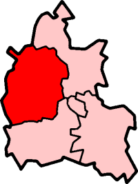
Coordinates: 51°51′32″N 1°27′29″W / 51.859°N 1.458°W Cornbury and Wychwood is a civil parish in West Oxfordshire. It includes the country estate of Cornbury Park (Ordnance Survey grid reference SP350181) and the ancient former Royal Forest of Wychwood, which covers several square miles between Cornbury Park, the village of Leafield (grid reference SP3215) and the hamlet of Mount Skippett (SP352159).
Further reading
- Watney, Vernon J (1910). Cornbury And The Forest Of Wychwood. London: Hatchards.
Oxfordshire • County Council elections • District Council elections • Witney County Constituency Towns Burford (Signet, Upton) • Carterton • Charlbury • Chipping Norton (Southcombe) • Witney (Cogges, Madley Park) • Woodstock (Hensington, Old Woodstock)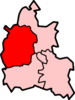
Large Villages Aston, Cote, Shifford and Chimney (Aston, Cote, Shifford, Chimney) • Bampton (Lower Haddon, Weald) • Brize Norton • Ducklington • Enstone (Church Enstone, Neat Enstone, Chalford, Cleveley, Fulwell, Gagingwell, Lidstone, Radford) • Eynsham (Barnard Gate) • Freeland • Hailey (New Yatt) • Hanborough (Church Hanborough, Long Hanborough) • Milton-under-Wychwood • Minster Lovell • North Leigh (East End, Wilcote) • Shipton-under-Wychwood • Standlake (Brighthampton) • Steeple Barton (Middle Barton) • StonesfieldOther Civil
Parishes
(Component
Villages
and Hamlets)Alvescot • Ascott-under-Wychwood (Ascott d'Oyley, Ascott Earl) • Asthall (Asthall Leigh, Worsham) • Black Bourton • Bladon • Blenheim • Broadwell • Bruern • Cassington (Worton) • Chadlington • Chastleton • Chilson (Shorthampton) • Churchill • Clanfield • Combe • Cornbury and Wychwood (Cornbury, Wychwood) • Cornwell • Crawley • Curbridge • Fawler • Fifield • Filkins and Broughton Poggs (Filkins, Broughton Poggs) • Finstock • Fulbrook • Glympton • Grafton and Radcot (Grafton, Radcot) • Great Tew • Hardwick-with-Yelford (Hardwick, Yelford) • Heythrop (Dunthrop) • Holwell • Idbury (Bould, Foscot) • Kelmscott • Kencot • Kiddington with Asterleigh (Asterleigh, Kiddington, Over Kiddington) • Kingham • Langford • Leafield • Lew • Little Faringdon • Little Tew • Lyneham • Northmoor • Over Norton • Ramsden (Mount Skippett) • Rollright (Great Rollright, Little Rollright) • Rousham • Salford • Sandford St. Martin (Ledwell) • Sarsden • Shilton • South Leigh • Spelsbury (Dean, Taston) • Stanton Harcourt • Swerford • Swinbrook and Widford (Swinbrook, Widford) • Tackley • Taynton • Westcott Barton • Westwell • Wootton (Dornford, Hordley) • Worton (Nether Worton, Over Worton)Former Districts
and BoroughsChipping Norton Rural District • Municipal Borough of Chipping Norton • Witney Urban District • Witney Rural District • Municipal Borough of Woodstock • Woodstock Rural DistrictFormer
ConstituenciesList of Parliamentary constituencies in Oxfordshire • List of places in Oxfordshire • List of civil parishes in Oxfordshire Categories:- Civil parishes in Oxfordshire
- West Oxfordshire
- Oxfordshire geography stubs
Wikimedia Foundation. 2010.