- Ducklington
-
Coordinates: 51°46′01″N 1°29′06″W / 51.767°N 1.485°W
Ducklington 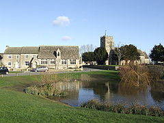
Ducklington parish church, village pond and former schoolhouse
 Ducklington
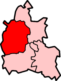
Ducklington shown within OxfordshirePopulation 1,573 (2001 census)[1] OS grid reference SP3507 Parish Ducklington District West Oxfordshire Shire county Oxfordshire Region South East Country England Sovereign state United Kingdom Post town Witney Postcode district OX29 Dialling code 01993 Police Thames Valley Fire Oxfordshire Ambulance South Central EU Parliament South East England UK Parliament Witney Website Ducklington Parish Council List of places: UK • England • Oxfordshire Ducklington is a village and civil parish on the River Windrush 1 mile (1.6 km) south of Witney in West Oxfordshire.
Contents
History
Ducklington is one of the first Saxon parishes to be recorded in Oxfordshire. In a charter of AD 958 King Edgar the Peaceable granted at Ducklington to his Minister, Eanulf. The toponym "Ducklington" may originate from "Ducel's Farm" or "the farm of the sons of Docca", but it is locally thought to have originated from the central duck pond, where many ducks and ducklings have lived for centuries. After the Norman Conquest Ducklington became a possession of Robert D'Oyly, a Norman nobleman who took part in William I's conquest of England. The Dyve family then held the Lordship of Ducklington throughout the 13th and 14th centuries, living there until early in the reign of Edward III.
The Church of England parish church of Saint Bartholomew[2] is 12th century.[3] The Gothic Revival architect E.G. Bruton restored the building in 1871.[3] The bell tower has a ring of six bells[4] including one cast by Henry Bagley of Chacombe in 1732.[5]
The village also has a Baptist Chapel.[6]
The former village schoolhouse was built in 1858.[3] The modern Ducklington Church of England Primary School is across the village green from the original site.[7][8]
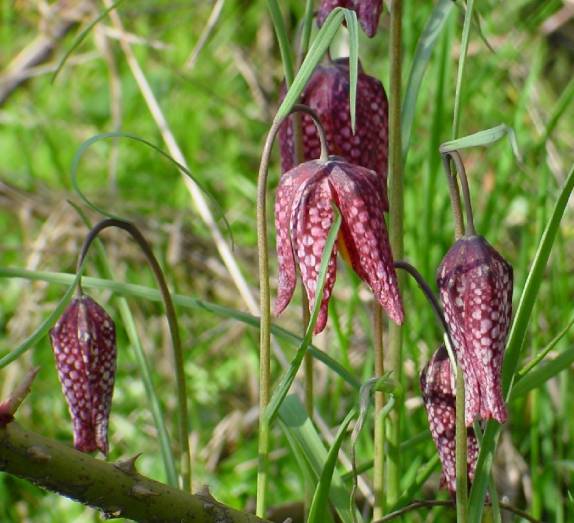
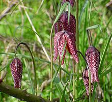 The Snake's Head Fritillaria
Today, Ducklington is famous for the rare Fritillary flower (of mainly the Snake's Head variety), many of which grow in a specially designated meadow just outside the village. Before the Second World War, many fritillaries had grown on fields all over the Windrush Valley. However, the national drive for food production during the war meant that most meadows were intensively ploughed, the rivers dredged, and consequently the fritillaries were lost. Only the current fritillary field was left coincidentally unploughed. The flowers have survived with help from both locals and farmers. Once a year, the local community celebrates Fritillary Sunday when the field, church and hall are opened so that the public may walk amongst and enjoy the flowers. The celebration has been featured in Country Life magazine.[citation needed]
Amenities
Ducklington has a Morris dancing group[9] and Mummers performances. It also has its own Morris Dance tradition; its own style of dance that was collected around the turn of the 19th Century. The Ducklington tradition is danced by many sides throughout Britain and the United States.[citation needed]
Recently[when?] Ducklington has hosted several flower and garden shows. Ducklington has two public houses: The Bell and The Strickland Arms as well as a sports and social club.
The former tithe barn is now the village hall, which has been renovated in the last few years[10]. It is used by village groups including the Parish Council and is the parish polling station in local and national elections. Ducklington has a Women's Institute.[11]
Sport
The village football team won the Oxfordshire Junior Shield in 2008.[12] It beat Freeland 1-0 in the final to win the trophy for the first time in its history. Ducklington Sports Club has numerous youth and adult cricket and football teams. The football section has four men's teams, a veterans' team and 9 boys' teams. The cricket section has two adult teams and three youth teams[13]. The sports club is currently trying to build a new pavilion as it has outgrown its current building.
References
- ^ "Area selected: West Oxfordshire (Non-Metropolitan District)". Neighbourhood Statistics: Full Dataset View. Office for National Statistics. http://www.neighbourhood.statistics.gov.uk/dissemination/LeadTableView.do?a=7&b=798813&c=Great+Tew&d=16&g=481687&i=1001x1003x1006&k=headcounts&o=1&m=0&r=1&s=1269378817046&enc=1&domainId=15&dsFamilyId=779. Retrieved 23 March 2010.
- ^ Parish Church of Saint Bartholomew
- ^ a b c Sherwood & Pevsner, 1974, page 589
- ^ Oxford Diocesan Guild of Church Bell Ringers, Witney & Woodstock Branch: Witney & Woodstock Bell Towers
- ^ Crossley & Currie, 1996, pages 140-148
- ^ Oxfordshire Churches & Chapels: Ducklington
- ^ Ducklington CE Primary School
- ^ Ducklington Pre-School
- ^ Ducklington Morris
- ^ District Council Grant Scheme
- ^ Oxfordshire Federation of Women's Institutes
- ^ Oxfordshire FA Results
- ^ Ducklington Sports Club website
Sources
- Crossley, Alan & Currie, C.R.J. (eds.); A.P. Baggs, Eleanor Chance, Christina Colvin, C.J. Day, Nesta Selwyn, S.C. Townley (1996). Victoria County History: A History of the County of Oxford, Volume 13. pp. 110–150.
- Sherwood, Jennifer; Pevsner, Nikolaus (1974). The Buildings of England: Oxfordshire. Harmondsworth: Penguin Books. pp. 588–590. ISBN 0 14 071045 0.
External links
 Media related to Ducklington at Wikimedia Commons
Oxfordshire • County Council elections • District Council elections • Witney County Constituency Towns Burford (Signet, Upton) • Carterton • Charlbury • Chipping Norton (Southcombe) • Witney (Cogges, Madley Park) • Woodstock (Hensington, Old Woodstock)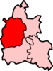
Large Villages Aston, Cote, Shifford and Chimney (Aston, Cote, Shifford, Chimney) • Bampton (Lower Haddon, Weald) • Brize Norton • Ducklington • Enstone (Church Enstone, Neat Enstone, Chalford, Cleveley, Fulwell, Gagingwell, Lidstone, Radford) • Eynsham (Barnard Gate) • Freeland • Hailey (New Yatt) • Hanborough (Church Hanborough, Long Hanborough) • Milton-under-Wychwood • Minster Lovell • North Leigh (East End, Wilcote) • Shipton-under-Wychwood • Standlake (Brighthampton) • Steeple Barton (Middle Barton) • StonesfieldOther Civil
Parishes
(Component
Villages
and Hamlets)Alvescot • Ascott-under-Wychwood (Ascott d'Oyley, Ascott Earl) • Asthall (Asthall Leigh, Worsham) • Black Bourton • Bladon • Blenheim • Broadwell • Bruern • Cassington (Worton) • Chadlington • Chastleton • Chilson (Shorthampton) • Churchill • Clanfield • Combe • Cornbury and Wychwood (Cornbury, Wychwood) • Cornwell • Crawley • Curbridge • Fawler • Fifield • Filkins and Broughton Poggs (Filkins, Broughton Poggs) • Finstock • Fulbrook • Glympton • Grafton and Radcot (Grafton, Radcot) • Great Tew • Hardwick-with-Yelford (Hardwick, Yelford) • Heythrop (Dunthrop) • Holwell • Idbury (Bould, Foscot) • Kelmscott • Kencot • Kiddington with Asterleigh (Asterleigh, Kiddington, Over Kiddington) • Kingham • Langford • Leafield • Lew • Little Faringdon • Little Tew • Lyneham • Northmoor • Over Norton • Ramsden (Mount Skippett) • Rollright (Great Rollright, Little Rollright) • Rousham • Salford • Sandford St. Martin (Ledwell) • Sarsden • Shilton • South Leigh • Spelsbury (Dean, Taston) • Stanton Harcourt • Swerford • Swinbrook and Widford (Swinbrook, Widford) • Tackley • Taynton • Westcott Barton • Westwell • Wootton (Dornford, Hordley) • Worton (Nether Worton, Over Worton)Former Districts
and BoroughsChipping Norton Rural District • Municipal Borough of Chipping Norton • Witney Urban District • Witney Rural District • Municipal Borough of Woodstock • Woodstock Rural DistrictFormer
ConstituenciesList of Parliamentary constituencies in Oxfordshire • List of places in Oxfordshire • List of civil parishes in Oxfordshire Categories:- Villages in Oxfordshire
- Sites of Special Scientific Interest in Oxfordshire
- Civil parishes in Oxfordshire
- West Oxfordshire


Wikimedia Foundation. 2010.