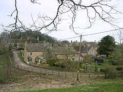
- Cornwell, Oxfordshire
-
Coordinates: 51°56′28″N 1°36′29″W / 51.941°N 1.608°W
Cornwell
Cornwell village
 Cornwell shown within Oxfordshire
Population 66 (2001 census)[1] OS grid reference SP2727 Parish Cornwell District West Oxfordshire Shire county Oxfordshire Region South East Country England Sovereign state United Kingdom Post town Chipping Norton Postcode district OX7 Dialling code 01608 Police Thames Valley Fire Oxfordshire Ambulance South Central EU Parliament South East England UK Parliament Witney List of places: UK • England • Oxfordshire Cornwell is a village and civil parish about 2.5 miles (4.0 km) west of Chipping Norton in West Oxfordshire.
History
The Church of England parish church of Saint Peter was originally Norman, and the chancel arch survives form this time.[2] Most of the windows are Decorated Gothic and Perpendicular Gothic additions.[3] The church was rebuilt in 1830 and 1882, when the present west window was added.[2] The south door has a porch with a sundial.[4]
The manor house dates from the 16th or 17th century, with a dining room and library panelled in about 1640[3] and 17th century stables and dovecote.[5] It was the home of Sir Thomas Penyston, 1st Baronet and his family occupied the house until the 19th century. A new front was built onto the house in about 1750, and the drawing room has a fireplace in the style of Robert Adam.[3] In 1939 the architect Clough Williams-Ellis restored the house, added a ballroom and laid out the gardens.[6]
Some of the cottages in the village are 17th century.[5] In 1939 Williams-Ellis, who had designed Portmeirion in north Wales, remodelled all the cottages in Cornwell and remodelled the former village school in neo-Georgian style as the Village Hall.[5]
References
- ^ "Area selected: West Oxfordshire (Non-Metropolitan District)". Neighbourhood Statistics: Full Dataset View. Office for National Statistics. http://neighbourhood.statistics.gov.uk/dissemination/viewFullDataset.do;jsessionid=ac1f930b30d73ec370d62b6f4444bc01a4cf1c94ffa8?instanceSelection=03070&productId=779&$ph=60_61&datasetInstanceId=3070&startColumn=1&numberOfColumns=8&containerAreaId=790500&nsjs=true&nsck=true&nssvg=true&nswid=1020. Retrieved 24 March 2010.
- ^ a b Sherwood & Pevsner, 1974, pages 555-556
- ^ a b c Sherwood & Pevsner, 1974, page 556
- ^ Oxfordshire Churches & Chapels: Cornwell
- ^ a b c Sherwood & Pevsner, 1974, page 557
- ^ Sherwood & Pevsner, 1974, pages 556-557
Sources
- Sherwood, Jennifer; Pevsner, Nikolaus (1974). Oxfordshire. The Buildings of England. Harmondsworth: Penguin Books. pp. 555–557. ISBN 0 14 071045 0.
Oxfordshire • County Council elections • District Council elections • Witney County Constituency Towns Burford (Signet, Upton) • Carterton • Charlbury • Chipping Norton (Southcombe) • Witney (Cogges, Madley Park) • Woodstock (Hensington, Old Woodstock)
Large Villages Aston, Cote, Shifford and Chimney (Aston, Cote, Shifford, Chimney) • Bampton (Lower Haddon, Weald) • Brize Norton • Ducklington • Enstone (Church Enstone, Neat Enstone, Chalford, Cleveley, Fulwell, Gagingwell, Lidstone, Radford) • Eynsham (Barnard Gate) • Freeland • Hailey (New Yatt) • Hanborough (Church Hanborough, Long Hanborough) • Milton-under-Wychwood • Minster Lovell • North Leigh (East End, Wilcote) • Shipton-under-Wychwood • Standlake (Brighthampton) • Steeple Barton (Middle Barton) • StonesfieldOther Civil
Parishes
(Component
Villages
and Hamlets)Alvescot • Ascott-under-Wychwood (Ascott d'Oyley, Ascott Earl) • Asthall (Asthall Leigh, Worsham) • Black Bourton • Bladon • Blenheim • Broadwell • Bruern • Cassington (Worton) • Chadlington • Chastleton • Chilson (Shorthampton) • Churchill • Clanfield • Combe • Cornbury and Wychwood (Cornbury, Wychwood) • Cornwell • Crawley • Curbridge • Fawler • Fifield • Filkins and Broughton Poggs (Filkins, Broughton Poggs) • Finstock • Fulbrook • Glympton • Grafton and Radcot (Grafton, Radcot) • Great Tew • Hardwick-with-Yelford (Hardwick, Yelford) • Heythrop (Dunthrop) • Holwell • Idbury (Bould, Foscot) • Kelmscott • Kencot • Kiddington with Asterleigh (Asterleigh, Kiddington, Over Kiddington) • Kingham • Langford • Leafield • Lew • Little Faringdon • Little Tew • Lyneham • Northmoor • Over Norton • Ramsden (Mount Skippett) • Rollright (Great Rollright, Little Rollright) • Rousham • Salford • Sandford St. Martin (Ledwell) • Sarsden • Shilton • South Leigh • Spelsbury (Dean, Taston) • Stanton Harcourt • Swerford • Swinbrook and Widford (Swinbrook, Widford) • Tackley • Taynton • Westcott Barton • Westwell • Wootton (Dornford, Hordley) • Worton (Nether Worton, Over Worton)Former Districts
and BoroughsChipping Norton Rural District • Municipal Borough of Chipping Norton • Witney Urban District • Witney Rural District • Municipal Borough of Woodstock • Woodstock Rural DistrictFormer
ConstituenciesList of Parliamentary constituencies in Oxfordshire • List of places in Oxfordshire • List of civil parishes in Oxfordshire Categories:- Oxfordshire geography stubs
- Villages in Oxfordshire
- Civil parishes in Oxfordshire
- West Oxfordshire
Wikimedia Foundation. 2010.


